A wide range of spatial data has been analysed to present this overview of the LN5 0 Postcode sector. If you would like anything added, please contact us.
The LN5 0 postcode sector stands on the Lincolnshire and Nottinghamshire border.
Did you know? According to the 2021 Census, the LN5 0 postcode sector is home to a bustling 6,110 residents!
Given that each sector allows for 400 unique postcode combinations. Letters C, I, K, M, O and V are not allowed in the last two letters of a postcode. With 221 postcodes already in use, this leaves 179 units available.
The largest settlement in the LN5 0 postal code is Navenby followed by Wellingore, and Brant Broughton.
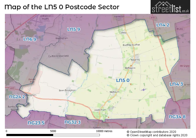
The LN5 0 Postcode shares a border with NG34 8 (SLEAFORD, Leasingham, Cranwell), LN4 2 (Bracebridge Heath, Potterhanworth, Nocton), LN4 3 (Metheringham, Ashby De La Launde, Digby), LN5 9 (Waddington, LINCOLN, Bassingham), LN6 9 (North Hykeham, Witham St. Hughs, South Hykeham), NG23 5 (Long Bennington, Claypole, Elston), NG24 2 (NEWARK, Coddington, Winthorpe) and NG32 3 (Ancaster, Caythorpe, Fulbeck).
Map of the LN5 0 Postcode Sector
Explore the LN5 0 postcode sector by using our interactive map.
The sector is within the post town of LINCOLN.
LN5 0 is a postcode sector within the LN5 postcode district which is within the LN Lincoln postcode area.
The Royal Mail delivery office for the LN5 0 postal sector is the Lincoln Delivery Office and Navenby Scale Payment Delivery Office and Welbourn Scale Payment Delivery Office.
The area of the LN5 0 postcode sector is 46.08 square miles which is 119.35 square kilometres or 29,492.80 square acres.
Waterways within the LN5 0 postcode sector include the River Witham, River Brant, Sand Beck.
Your support helps keep this site running!
If you enjoy using this website, consider buying me a coffee to help cover hosting costs.

| L | N | 5 | - | 0 | X | X |
| L | N | 5 | Space | 0 | Letter | Letter |
Official List of Streets
Navenby (57 Streets)
Wellingore (29 Streets)
Leadenham (17 Streets)
Welbourn (20 Streets)
Boothby Graffoe (8 Streets)
Coleby (14 Streets)
(31 Streets)
Brant Broughton (21 Streets)
Beckingham (10 Streets)
Temple Bruer (1 Streets)
Unofficial Streets or Alternative Spellings
Navenby
WORKSHOP MEWSBracebridge Heath
GRANTHAM ROAD SLEAFORD ROADAshby De La Launde
CUCKOO LANEHarmston
BROUGHTON LANECarlton-le-Moorland
BRIGG LANE BROUGHTON ROAD CLAY LANEBassingham
NAVENBY LANEWeather Forecast for LN5 0
Weather Forecast for Welbourn
| Time Period | Icon | Description | Temperature | Rain Probability | Wind |
|---|---|---|---|---|---|
| 03:00 to 06:00 | Overcast | 4.0°C (feels like 2.0°C) | 11.00% | S 4 mph | |
| 06:00 to 09:00 | Overcast | 4.0°C (feels like 2.0°C) | 10.00% | SSE 4 mph | |
| 09:00 to 12:00 | Overcast | 4.0°C (feels like 2.0°C) | 10.00% | SSE 7 mph | |
| 12:00 to 15:00 | Overcast | 6.0°C (feels like 3.0°C) | 9.00% | S 9 mph | |
| 15:00 to 18:00 | Overcast | 6.0°C (feels like 3.0°C) | 9.00% | S 9 mph | |
| 18:00 to 21:00 | Overcast | 5.0°C (feels like 2.0°C) | 9.00% | SSE 9 mph | |
| 21:00 to 00:00 | Cloudy | 4.0°C (feels like 1.0°C) | 5.00% | SSE 9 mph |
| Time Period | Icon | Description | Temperature | Rain Probability | Wind |
|---|---|---|---|---|---|
| 00:00 to 03:00 | Clear night | 2.0°C (feels like -2.0°C) | 2.00% | S 9 mph | |
| 03:00 to 06:00 | Clear night | 1.0°C (feels like -3.0°C) | 2.00% | SSE 9 mph | |
| 06:00 to 09:00 | Partly cloudy (night) | 1.0°C (feels like -3.0°C) | 2.00% | SSE 9 mph | |
| 09:00 to 12:00 | Partly cloudy (day) | 1.0°C (feels like -2.0°C) | 3.00% | S 9 mph | |
| 12:00 to 15:00 | Sunny day | 5.0°C (feels like 2.0°C) | 3.00% | S 9 mph | |
| 15:00 to 18:00 | Sunny day | 6.0°C (feels like 4.0°C) | 2.00% | SSW 9 mph | |
| 18:00 to 21:00 | Clear night | 3.0°C (feels like 1.0°C) | 1.00% | SSW 7 mph | |
| 21:00 to 00:00 | Clear night | 3.0°C (feels like 0.0°C) | 1.00% | SSW 7 mph |
| Time Period | Icon | Description | Temperature | Rain Probability | Wind |
|---|---|---|---|---|---|
| 00:00 to 03:00 | Clear night | 2.0°C (feels like -1.0°C) | 1.00% | SSW 7 mph | |
| 03:00 to 06:00 | Clear night | 2.0°C (feels like -1.0°C) | 2.00% | SSW 7 mph | |
| 06:00 to 09:00 | Cloudy | 2.0°C (feels like -1.0°C) | 5.00% | SSW 7 mph | |
| 09:00 to 12:00 | Cloudy | 3.0°C (feels like 0.0°C) | 5.00% | SSW 9 mph | |
| 12:00 to 15:00 | Cloudy | 7.0°C (feels like 4.0°C) | 5.00% | SSW 11 mph | |
| 15:00 to 18:00 | Cloudy | 8.0°C (feels like 5.0°C) | 5.00% | SSW 11 mph | |
| 18:00 to 21:00 | Partly cloudy (night) | 6.0°C (feels like 3.0°C) | 2.00% | S 11 mph | |
| 21:00 to 00:00 | Cloudy | 6.0°C (feels like 2.0°C) | 5.00% | SSW 11 mph |
| Time Period | Icon | Description | Temperature | Rain Probability | Wind |
|---|---|---|---|---|---|
| 00:00 to 03:00 | Cloudy | 6.0°C (feels like 2.0°C) | 7.00% | SSW 13 mph | |
| 03:00 to 06:00 | Partly cloudy (night) | 6.0°C (feels like 2.0°C) | 8.00% | SSW 13 mph | |
| 06:00 to 09:00 | Cloudy | 6.0°C (feels like 2.0°C) | 12.00% | SSW 13 mph | |
| 09:00 to 12:00 | Partly cloudy (day) | 7.0°C (feels like 3.0°C) | 12.00% | SSW 13 mph | |
| 12:00 to 15:00 | Partly cloudy (day) | 9.0°C (feels like 6.0°C) | 14.00% | SSW 13 mph | |
| 15:00 to 18:00 | Cloudy | 10.0°C (feels like 7.0°C) | 19.00% | SW 13 mph | |
| 18:00 to 21:00 | Cloudy | 8.0°C (feels like 5.0°C) | 13.00% | SW 11 mph | |
| 21:00 to 00:00 | Cloudy | 7.0°C (feels like 4.0°C) | 9.00% | WSW 9 mph |
Schools and Places of Education Within the LN5 0 Postcode Sector
Brant Broughton Church of England and Methodist Primary School
Voluntary controlled school
Brant Broughton Primary School, Lincoln, Lincolnshire, LN5 0RP
Head: Mrs Liz Moore
Ofsted Rating: Good
Inspection: 2019-06-06 (2067 days ago)
Website: Visit Brant Broughton Church of England and Methodist Primary School Website
Phone: 01400272035
Number of Pupils: 98
Coleby Church of England (Controlled) Primary School
Voluntary controlled school
Rectory Road, Lincoln, Lincolnshire, LN5 0AJ
Head: Mrs Tracy Boulter
Ofsted Rating: Good
Inspection: 2023-02-28 (704 days ago)
Website: Visit Coleby Church of England (Controlled) Primary School Website
Phone: 01522810627
Number of Pupils: 46
Navenby Church of England Primary School
Voluntary controlled school
East Road, Lincoln, Lincolnshire, LN5 0EP
Head: Mr Craig Elliott
Ofsted Rating: Good
Inspection: 2021-12-08 (1151 days ago)
Website: Visit Navenby Church of England Primary School Website
Phone: 01522810628
Number of Pupils: 193
Sir William Robertson Academy, Welbourn
Academy converter
Main Road, Lincoln, Lincolnshire, LN5 0PA
Head: Mr Mark Guest
Ofsted Rating: Good
Inspection: 2019-03-19 (2146 days ago)
Website: Visit Sir William Robertson Academy, Welbourn Website
Phone: 01400272422
Number of Pupils: 1047
The Welbourn Church of England Primary School
Voluntary controlled school
High Street, Lincoln, Lincolnshire, LN5 0NH
Head: Mrs Tracy Boulter
Ofsted Rating: Good
Inspection: 2023-06-21 (591 days ago)
Website: Visit The Welbourn Church of England Primary School Website
Phone: 01400272798
Number of Pupils: 58
House Prices in the LN5 0 Postcode Sector
| Type of Property | 2018 Average | 2018 Sales | 2017 Average | 2017 Sales | 2016 Average | 2016 Sales | 2015 Average | 2015 Sales |
|---|---|---|---|---|---|---|---|---|
| Detached | £341,429 | 78 | £317,317 | 78 | £293,558 | 61 | £264,305 | 58 |
| Semi-Detached | £214,440 | 25 | £239,936 | 18 | £203,036 | 25 | £161,070 | 20 |
| Terraced | £147,304 | 14 | £253,300 | 14 | £206,880 | 15 | £153,030 | 15 |
| Flats | £0 | 0 | £0 | 0 | £90,000 | 1 | £0 | 0 |
Important Postcodes LN5 0 in the Postcode Sector
LN5 0AJ is the postcode for Coleby C of E (Controlled) Primary School, Rectory Road, and Coleby C Of E (Controlled) Primary School, Rectory Road, Coleby
LN5 0EP is the postcode for Navenby C of E School, East Road, and NAVENBY C OF E SCHOOL, EAST ROAD, NAVENBY
LN5 0PA is the postcode for AVELING BLOCK, Sir William Robertson Academy, Main Road, FANE BLOCK, Sir William Robertson Academy, Main Road, DIXON BLOCK, Sir William Robertson Academy, Main Road, MAIN BUILDING, Sir William Robertson Academy, Main Road, and OAKRIDGE BLOCK, Sir William Robertson Academy, Main Road
LN5 0QB is the postcode for Leadenham C of E (Aided) Primary School, Main Road, Leadenham, and Leadenham C of E (Aided) Primary School, Main Road
LN5 0RP is the postcode for Brant Broughton C of E Methodist Primary School, Mill Lane
| The LN5 0 Sector is within these Local Authorities |
|
|---|---|
| The LN5 0 Sector is within these Counties |
|
| The LN5 0 Sector is within these Water Company Areas |
|