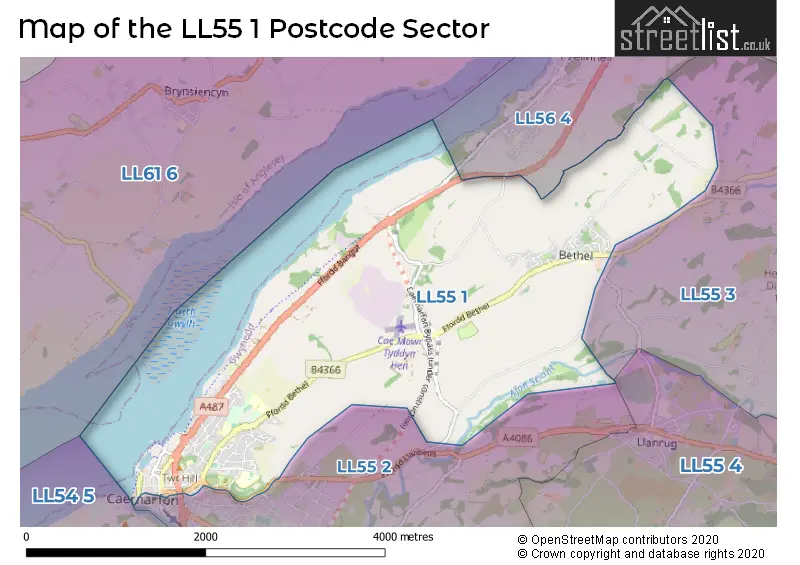
A wide range of spatial data has been analysed to present this overview of the LL55 1 Postcode sector. If you would like anything added, please contact us.
The LL55 1 postcode sector is within the county of Gwynedd.
Did you know? According to the 2021 Census, the LL55 1 postcode sector is home to a bustling 5,346 residents!
Given that each sector allows for 400 unique postcode combinations. Letters C, I, K, M, O and V are not allowed in the last two letters of a postcode. With 173 postcodes already in use, this leaves 227 units available.
The largest settlement in the LL55 1 postal code is CAERNARFON followed by BETHEL, and LLANFAIR IS GAER.
The LL55 1 Postcode shares a border with LL55 3 (DEINIOLEN, PENISARWAUN, DINORWIG), LL55 4 (LLANBERIS, LLANRUG, WAUNFAWR), LL55 2 (CAERNARFON, Caeathro, BONTNEWYDD) and LL56 4 (Y FELINHELI).
Map of the LL55 1 Postcode Sector
Explore the LL55 1 postcode sector by using our interactive map.
The sector is within the post town of CAERNARFON.
LL55 1 is a postcode sector within the LL55 postcode district which is within the LL Llandudno postcode area.
The Royal Mail delivery office for the LL55 1 postal sector is the Caernarfon Delivery Office.
The area of the LL55 1 postcode sector is 4.88 square miles which is 12.64 square kilometres or 3,122.95 square acres.
Your support helps keep this site running!
If you enjoy using this website, consider buying me a coffee to help cover hosting costs.


| L | L | 5 | 5 | - | 1 | X | X |
| L | L | 5 | 5 | Space | 1 | Letter | Letter |
Official List of Streets
CAERNARFON (89 Streets)
Bethel (13 Streets)
Rhosbodrual (1 Streets)
Unofficial Streets or Alternative Spellings
Bethel
Y DD�LY FELINHELI
CAERNARFON ROADCAERNARFON
CASTLE DITCH CASTLE HILLRhosbodrual
LLANBERIS ROADWeather Forecast for LL55 1
Weather Forecast for Menai Strait

House Prices in the LL55 1 Postcode Sector
| Type of Property | 2018 Average | 2018 Sales | 2017 Average | 2017 Sales | 2016 Average | 2016 Sales | 2015 Average | 2015 Sales |
|---|---|---|---|---|---|---|---|---|
| Detached | £233,063 | 16 | £257,048 | 21 | £226,000 | 15 | £215,909 | 21 |
| Semi-Detached | £170,158 | 24 | £172,384 | 13 | £167,068 | 22 | £152,779 | 14 |
| Terraced | £144,875 | 36 | £145,806 | 27 | £122,330 | 22 | £132,850 | 24 |
| Flats | £210,500 | 5 | £154,500 | 4 | £148,250 | 4 | £95,333 | 3 |
Important Postcodes LL55 1 in the Postcode Sector
LL55 1AS is the postcode for Gwynedd Council, Caernarfon Library, Pavilion Hill
LL55 1BN is the postcode for Swyddfa Ardal Arfon, Penrallt
LL55 1BU is the postcode for CAERNARFON D.H.Q., North Wales Police, Maesincla Lane
LL55 1DB is the postcode for Plas Maesincla
LL55 1DF is the postcode for Ysgol Gynradd Maesincla
LL55 1DU is the postcode for Arfon Leisure Centre, Bethel Road, Arfon Tennis Centre, Bethel Road, and Ysgol Pendalar, Bethel Road
LL55 1EP is the postcode for Welsh Government, Government Buildings
LL55 1HU is the postcode for B C U Health Board, Eryldon, Campbell Road
LL55 1HW is the postcode for OLD BLOCK, Ysgol Syr Hugh Owen, Bethel Road, NEUADD BLOCK, Ysgol Syr Hugh Owen, Bethel Road, CANTEEN BLOCK D, Ysgol Syr Hugh Owen, Bethel Road, ADMIN BLOCK, Ysgol Syr Hugh Owen, Bethel Road, MATHS BLOCK, Ysgol Syr Hugh Owen, Bethel Road, Ysgol Syr Hugh Owen, Bethel Road, and DY BLOCK, Ysgol Syr Hugh Owen, Bethel Road
LL55 1PS is the postcode for Y Frondeg Hostel, Maes Heulog
LL55 1SE is the postcode for Tourist Information Centre, Oriel Pendeitsh, Castle Street
LL55 1SH is the postcode for BLOCK B, Gwynedd Council, Shirehall Street, Gwynedd Council, Shirehall Street, BLOCK J, Gwynedd Council, Shirehall Street, and BLOCK A, Gwynedd Council, Shirehall Street
LL55 1SQ is the postcode for Main Building, Hafan Iechyd Surgery, Plot Surg Victoria Park
LL55 1SR is the postcode for Archifdy Caernarfon, Doc Fictoria
LL55 1UE is the postcode for Plas Menai National Watersports Centre
LL55 1ZH is the postcode for Canolfan Ddysgu, Shirehall Street
| The LL55 1 Sector is within these Local Authorities |
|
|---|---|
| The LL55 1 Sector is within these Counties |
|
| The LL55 1 Sector is within these Water Company Areas |
|