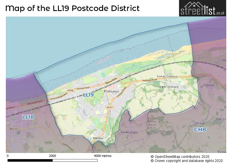
Map of the LL19 Postcode District
Explore the postcode district by using our interactive map.
Circles represent recorded crime; the larger the circle, the higher the crime rates.
Your support helps keep this site running!
If you enjoy using this website, consider buying me a coffee to help cover hosting costs.
Where is the LL19 District?
To give you an idea where the district is located we have created the following table showing nearby towns.
Nearest Towns to LL19
| Town | Distance (miles) | Direction |
|---|---|---|
| Rhyl | 4.17 | WSW |
| Rhuddlan | 4.20 | SW |
| St Asaph | 5.65 | SSW |
| Caerwys | 7.02 | SSE |
| Holywell | 8.25 | ESE |
| Abergele | 8.53 | WSW |
| West Kirby | 9.10 | ENE |
| Hoylake | 10.00 | ENE |
| Denbigh | 10.44 | S |
| Flint | 12.18 | ESE |
| Heswall | 12.32 | E |
| Colwyn Bay | 13.29 | WSW |
| Neston | 13.98 | ESE |
| Wallasey | 14.96 | ENE |
| Mold | 15.50 | SE |
| Ruthin | 15.54 | SSE |
| Connah's Quay | 16.15 | ESE |
| Birkenhead | 16.24 | ENE |
| Bebington | 17.23 | E |
The post town for this district is PRESTATYN.
Postcode Information for District LL19 (Total Geographical Postcodes: 656)
| Location | Post Town | Sector | Number of Postcodes |
|---|---|---|---|
| PRESTATYN | PRESTATYN | LL19 8 | 254 |
| PRESTATYN | PRESTATYN | LL19 7 | 219 |
| PRESTATYN | PRESTATYN | LL19 9 | 146 |
| Gronant | PRESTATYN | LL19 9 | 36 |
| Bryn Newydd | PRESTATYN | LL19 9 | 1 |
Retail and Shopping in LL19
Street
Town
Locality
Number of Shops
Central Postcode
View on Google Maps
HIGH STREET
PRESTATYN
115
LL19 9BH
View on Google Maps
NANT HALL ROAD
PRESTATYN
20
LL19 9BJ
View on Google Maps
MELIDEN ROAD
PRESTATYN
17
LL19 9RT
View on Google Maps
BASTION ROAD
PRESTATYN
16
LL19 7ES
View on Google Maps
VICTORIA ROAD
PRESTATYN
12
LL19 7SR
View on Google Maps
KINGS AVENUE
PRESTATYN
8
LL19 9AA
View on Google Maps
| Street | Town | Locality | Number of Shops | Central Postcode | View on Google Maps |
|---|---|---|---|---|---|
| HIGH STREET | PRESTATYN | 115 | LL19 9BH | View on Google Maps | |
| NANT HALL ROAD | PRESTATYN | 20 | LL19 9BJ | View on Google Maps | |
| MELIDEN ROAD | PRESTATYN | 17 | LL19 9RT | View on Google Maps | |
| BASTION ROAD | PRESTATYN | 16 | LL19 7ES | View on Google Maps | |
| VICTORIA ROAD | PRESTATYN | 12 | LL19 7SR | View on Google Maps | |
| KINGS AVENUE | PRESTATYN | 8 | LL19 9AA | View on Google Maps |
The primary settlement in the LL19 postcode district is Prestatyn, which is located in the county of Clwyd. Other significant settlements in this district include Bryn Newydd and Gronant. The most significant post town in this district is also Prestatyn, which is located in Clwyd, Wales.
When it comes to local government, postal geography often disregards political borders. However, this district intersects the following councils: the district mostly encompasses the Sir Ddinbych - Denbighshire (563 postal codes), and finally, the Sir y Fflint - Flintshire area (36 postal codes).
The largest settlement in the LL19 postal code is PRESTATYN followed by Gronant, and MELIDEN.
The postcode area has a boundary with The Irish Sea.
The LL19 Postcode shares a border with CH8 (HOLYWELL, GREENFIELD, MOSTYN) and LL18 (RHYL, KINMEL BAY, Rhuddlan).


Dentists in the LL19 District
| # | Name | Address | Type | Contact |
|---|---|---|---|---|
| 1 | Prestatyn Dental Practice | MIDLAND BANK CHAMBERS , 37 HIGH STREET , PRESTATYN , CLWYD , LL19 9AH | GENERAL DENTAL PRACTICE | |
| 2 | Kings Avenue (dental Surgery) | KINGS AVENUE , PRESTATYN , LL19 9AA | GENERAL DENTAL PRACTICE |
Doctors in the LL19 District
| # | Name | Address | Type | Contact |
|---|---|---|---|---|
| 1 | Healthy Prestatyn | , NANT HALL ROAD PRESTATYN , PRESTATYN , CLWYD , LL19 9LN | GP PRACTICE | |
| 2 | Park House Surgery | , PRESTATYN , CLWYD , LL19 9LN | GP PRACTICE | |
| 3 | Seabank Surgery | , TOWER GAR , PRESTATYN , CLWYD , LL19 7UN | GP PRACTICE | |
| 4 | Upcc At Healthy Prestatyn | , NANT HALL ROAD , PRESTATYN , LL19 9LG | GP PRACTICE |
Chemists in the LL19 District
| # | Name | Address | Type | Contact |
|---|---|---|---|---|
| 1 | Rowlands Pharmacy | 82-84 HIGH STREET , PRESTATYN , LL19 9BE | PHARMACY | |
| 2 | Pritchards Pharmacy | 165 MELIDEN ROAD , PRESTATYN , LL19 8NA | PHARMACY | |
| 3 | Pritchards Pharmacy | 99 VICTORIA ROAD , PRESTATYN , LL19 7SR | PHARMACY | |
| 4 | Boots | UNIT 6 , PRESTATYN SHOPPING PARK , NANT HALL ROAD , PRESTATYN , LL19 9BJ | PHARMACY | |
| 5 | Allied Pharmacy Prestatyn | 101-103 HIGH STREET , PRESTATYN , LL19 9AP | PHARMACY |
Opticians in the LL19 District
| # | Name | Address | Type | Contact |
|---|---|---|---|---|
| 1 | SPECSAVERS (PRESTATYN) | 124 HIGH STREET , PRESTATYN , CLWYD , LL19 9BH | OPTICAL SITE | |
| 2 | MORRICE-EVANS OPTOMETRISTS | 171 HIGH STREET , PRESTATYN , CLWYD , LL19 9AY | OPTICAL SITE | |
| 3 | HOME VISION CARE LTD - MELIDEN | SWISS COTTAGE , FFORDD BRYNIAU , MELIDEN , PRESTATYN , CLWYD , LL19 8RD | OPTICAL SITE |
Stations in the Sector
Prestatyn
CRS Code: PRT
Operator: AW
Line: North Wales Coast Line
Company: Transport for Wales
Accessable Motorway Junctions
M53 J5
Average Driving Time from within the district: 36.98
Average Driving Distance: 27.38
Number of Postcodes that can access the Motorway Junction: 596
M53 J4
Average Driving Time from within the district: 40.86
Average Driving Distance: 31.40
Number of Postcodes that can access the Motorway Junction: 596
M53 J3
Average Driving Time from within the district: 43.79
Average Driving Distance: 34.42
Number of Postcodes that can access the Motorway Junction: 596
M53 J2
Average Driving Time from within the district: 46.30
Average Driving Distance: 37.03
Number of Postcodes that can access the Motorway Junction: 596
M53 J1
Average Driving Time from within the district: 47.08
Average Driving Distance: 37.78
Number of Postcodes that can access the Motorway Junction: 596
Weather Forecast for Prestatyn
| Time Period | Icon | Description | Temperature | Rain Probability | Wind |
|---|---|---|---|---|---|
| 09:00 to 12:00 | Cloudy | 5.0°C (feels like 2.0°C) | 8.00% | S 7 mph | |
| 12:00 to 15:00 | Cloudy | 7.0°C (feels like 4.0°C) | 6.00% | S 7 mph | |
| 15:00 to 18:00 | Cloudy | 7.0°C (feels like 5.0°C) | 6.00% | S 7 mph | |
| 18:00 to 21:00 | Cloudy | 5.0°C (feels like 2.0°C) | 7.00% | SSE 7 mph | |
| 21:00 to 00:00 | Cloudy | 4.0°C (feels like 1.0°C) | 6.00% | SSE 7 mph |
| Time Period | Icon | Description | Temperature | Rain Probability | Wind |
|---|---|---|---|---|---|
| 00:00 to 03:00 | Cloudy | 3.0°C (feels like 0.0°C) | 6.00% | SSE 7 mph | |
| 03:00 to 06:00 | Cloudy | 2.0°C (feels like -1.0°C) | 6.00% | SSE 7 mph | |
| 06:00 to 09:00 | Cloudy | 2.0°C (feels like -1.0°C) | 8.00% | SSE 7 mph | |
| 09:00 to 12:00 | Cloudy | 2.0°C (feels like 0.0°C) | 8.00% | SSE 7 mph | |
| 12:00 to 15:00 | Cloudy | 4.0°C (feels like 2.0°C) | 7.00% | SSE 4 mph | |
| 15:00 to 18:00 | Cloudy | 5.0°C (feels like 3.0°C) | 8.00% | E 4 mph | |
| 18:00 to 21:00 | Cloudy | 3.0°C (feels like 1.0°C) | 10.00% | SE 4 mph | |
| 21:00 to 00:00 | Overcast | 3.0°C (feels like 0.0°C) | 15.00% | S 4 mph |
| Time Period | Icon | Description | Temperature | Rain Probability | Wind |
|---|---|---|---|---|---|
| 00:00 to 03:00 | Overcast | 3.0°C (feels like 1.0°C) | 16.00% | S 4 mph | |
| 03:00 to 06:00 | Overcast | 3.0°C (feels like 1.0°C) | 15.00% | S 7 mph | |
| 06:00 to 09:00 | Overcast | 3.0°C (feels like 1.0°C) | 15.00% | SSW 7 mph | |
| 09:00 to 12:00 | Cloudy | 4.0°C (feels like 1.0°C) | 11.00% | SSW 7 mph | |
| 12:00 to 15:00 | Cloudy | 6.0°C (feels like 3.0°C) | 10.00% | SSW 9 mph | |
| 15:00 to 18:00 | Cloudy | 7.0°C (feels like 4.0°C) | 12.00% | SW 9 mph | |
| 18:00 to 21:00 | Cloudy | 5.0°C (feels like 3.0°C) | 10.00% | SSW 9 mph | |
| 21:00 to 00:00 | Cloudy | 5.0°C (feels like 2.0°C) | 10.00% | SSW 9 mph |
| Postal Sector | Delivery Office |
|---|---|
| LL19 7 | Prestatyn Delivery Office |
| LL19 8 | Prestatyn Delivery Office |
| LL19 9 | Prestatyn Delivery Office |
| L | L | 1 | 9 | - | X | X | X |
| L | L | 1 | 9 | Space | Numeric | Letter | Letter |
Street List for the LL19 District
Current Monthly Rental Prices
| # Bedrooms | Min Price | Max Price | Avg Price |
|---|---|---|---|
| 2 | £650 | £775 | £713 |
| 3 | £895 | £895 | £895 |
Current House Prices
| # Bedrooms | Min Price | Max Price | Avg Price |
|---|---|---|---|
| £125,000 | £400,000 | £270,800 | |
| 1 | £82,500 | £150,000 | £109,490 |
| 2 | £85,000 | £365,000 | £189,526 |
| 3 | £95,000 | £530,000 | £254,198 |
| 4 | £184,900 | £685,000 | £410,468 |
| 5 | £300,000 | £975,000 | £547,333 |
Estate Agents
| Logo | Name | Brand Name | Address | Contact Number |
|---|---|---|---|---|
 | Prestatyn | Williams Estates | 11 Meliden Road, Prestatyn, LL19 9SB | 01745 770963 |
 | Prestatyn | Peter Large Estate Agents | 19 Meliden Road, Prestatyn, LL19 9SD | 01745 770605 |
 | Rhuddlan | LL Estates | High Street Rhuddlan LL18 2UA | 01745 770879 |
 | Prestatyn | Beresford Adams | 95-97 High Street, Prestatyn, Denbighshire, LL19 9AP | 01745 777908 |
 | covering Llandudno | Purplebricks | Suite 7 First Floor Cranmore Drive Shirley Solihull B90 4RZ | 020 3907 3310 |
Yearly House Price Averages for the District
| Type of Property | 2018 Average | 2018 Sales | 2017 Average | 2017 Sales | 2016 Average | 2016 Sales | 2015 Average | 2015 Sales |
|---|---|---|---|---|---|---|---|---|
| Detached | £187,057 | 191 | £185,950 | 198 | £173,350 | 178 | £162,257 | 181 |
| Semi-Detached | £134,266 | 128 | £133,337 | 163 | £128,159 | 123 | £124,077 | 119 |
| Terraced | £114,323 | 31 | £97,950 | 30 | £97,606 | 36 | £102,561 | 30 |
| Flats | £131,151 | 48 | £119,291 | 31 | £69,017 | 15 | £73,497 | 16 |
