A wide range of spatial data has been analysed to present this overview of the LL12 9 Postcode sector. If you would like anything added, please contact us.
The LL12 9 postcode sector is within the county of Clwyd.
Did you know? According to the 2021 Census, the LL12 9 postcode sector is home to a bustling 5,255 residents!
Given that each sector allows for 400 unique postcode combinations. Letters C, I, K, M, O and V are not allowed in the last two letters of a postcode. With 202 postcodes already in use, this leaves 198 units available.
The largest settlement in the LL12 9 postal code is Caergwrle followed by Hope, and CEFN-Y-BEDD.
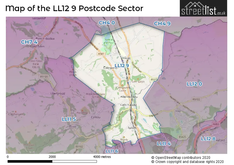
The LL12 9 Postcode shares a border with CH4 0 (BROUGHTON, PENYFFORDD, PENYMYNYDD), CH7 4 (LEESWOOD, TREUDDYN, LLANARMON YN IAL), CH4 9 (Higher Kinnerton, Pulford, Dodleston), LL11 5 (BRYMBO, BWLCHGWYN, TANYFRON), LL11 6 (NEW BROUGHTON, BRYNTEG, PENTRE BROUGHTON), LL12 0 (LLAY, ROSSETT, BURTON) and LL11 4 (GWERSYLLT, SUMMERHILL, BRADLEY).
Map of the LL12 9 Postcode Sector
Explore the LL12 9 postcode sector by using our interactive map.
The sector is within the post town of WREXHAM.
LL12 9 is a postcode sector within the LL12 postcode district which is within the LL Llandudno postcode area.
The Royal Mail delivery office for the LL12 9 postal sector is the Wrexham Delivery Office.
The area of the LL12 9 postcode sector is 5.60 square miles which is 14.51 square kilometres or 3,584.57 square acres.
Your support helps keep this site running!
If you enjoy using this website, consider buying me a coffee to help cover hosting costs.


| L | L | 1 | 2 | - | 9 | X | X |
| L | L | 1 | 2 | Space | 9 | Letter | Letter |
Official List of Streets
Hope (34 Streets)
Cefn-y-Bedd (22 Streets)
Caergwrle (35 Streets)
Unofficial Streets or Alternative Spellings
Higher Kinnerton
KINNERTON ROAD MIDDLE LANE SANDY LANERossett
DARK LANECaergwrle
PLAS-Y-BWL ALUNDALE ROAD ALYN FIELDS ALYN INDUSTRIAL ESTATE BARROCKS LANE BELLAN LANE BITHELLS LANE BLAST ROAD BRIDGE BRYN-YORKIN ROAD CYMAU ROAD GWERN LANE HOPE HALL DRIVE HUXLEYS LANE LLYS CELYN MAES ALYN MOUNTAIN ROAD OAK ALYN ROAD OLD SCHOOL COURT PEN-Y-BRYN PENTRE LANE PUGHS YARD ROBERTS CROFT STONE ROW TAN- YR- ALLT TIR Y FRON LANE TOP WINDY HILL TUDOR COURT TY CERRIG DRIVECefn-y-Bedd
CAE-PEN-TY ROADFfrith
MINERA ROADBrymbo
GLYON LANEWeather Forecast for LL12 9
Weather Forecast for Treuddyn
| Time Period | Icon | Description | Temperature | Rain Probability | Wind |
|---|---|---|---|---|---|
| 12:00 to 15:00 | Partly cloudy (day) | 5.0°C (feels like 1.0°C) | 0.00% | S 11 mph | |
| 15:00 to 18:00 | Cloudy | 6.0°C (feels like 2.0°C) | 4.00% | S 9 mph | |
| 18:00 to 21:00 | Cloudy | 4.0°C (feels like 1.0°C) | 5.00% | S 9 mph | |
| 21:00 to 00:00 | Cloudy | 4.0°C (feels like 0.0°C) | 5.00% | S 11 mph |
| Time Period | Icon | Description | Temperature | Rain Probability | Wind |
|---|---|---|---|---|---|
| 00:00 to 03:00 | Cloudy | 4.0°C (feels like 0.0°C) | 5.00% | S 11 mph | |
| 03:00 to 06:00 | Cloudy | 3.0°C (feels like 0.0°C) | 7.00% | S 11 mph | |
| 06:00 to 09:00 | Overcast | 4.0°C (feels like 0.0°C) | 11.00% | S 9 mph | |
| 09:00 to 12:00 | Overcast | 4.0°C (feels like 1.0°C) | 11.00% | S 7 mph | |
| 12:00 to 15:00 | Cloudy | 6.0°C (feels like 3.0°C) | 8.00% | SSW 7 mph | |
| 15:00 to 18:00 | Overcast | 6.0°C (feels like 5.0°C) | 11.00% | SW 7 mph | |
| 18:00 to 21:00 | Cloudy | 4.0°C (feels like 2.0°C) | 5.00% | SSW 4 mph | |
| 21:00 to 00:00 | Cloudy | 4.0°C (feels like 1.0°C) | 5.00% | SSW 7 mph |
| Time Period | Icon | Description | Temperature | Rain Probability | Wind |
|---|---|---|---|---|---|
| 00:00 to 03:00 | Overcast | 3.0°C (feels like 1.0°C) | 8.00% | SSW 7 mph | |
| 03:00 to 06:00 | Overcast | 3.0°C (feels like 0.0°C) | 8.00% | SSW 7 mph | |
| 06:00 to 09:00 | Overcast | 3.0°C (feels like 0.0°C) | 8.00% | SSW 9 mph | |
| 09:00 to 12:00 | Cloudy | 5.0°C (feels like 1.0°C) | 5.00% | SSW 11 mph | |
| 12:00 to 15:00 | Cloudy | 7.0°C (feels like 4.0°C) | 6.00% | SSW 16 mph | |
| 15:00 to 18:00 | Cloudy | 8.0°C (feels like 4.0°C) | 6.00% | SSW 16 mph | |
| 18:00 to 21:00 | Cloudy | 7.0°C (feels like 3.0°C) | 9.00% | SSW 16 mph | |
| 21:00 to 00:00 | Cloudy | 7.0°C (feels like 3.0°C) | 12.00% | SSW 16 mph |
| Time Period | Icon | Description | Temperature | Rain Probability | Wind |
|---|---|---|---|---|---|
| 00:00 to 03:00 | Cloudy | 7.0°C (feels like 3.0°C) | 17.00% | SSW 18 mph | |
| 03:00 to 06:00 | Overcast | 7.0°C (feels like 3.0°C) | 24.00% | SSW 16 mph | |
| 06:00 to 09:00 | Overcast | 7.0°C (feels like 3.0°C) | 27.00% | SSW 16 mph | |
| 09:00 to 12:00 | Light rain | 7.0°C (feels like 4.0°C) | 52.00% | SW 16 mph | |
| 12:00 to 15:00 | Light rain | 8.0°C (feels like 5.0°C) | 49.00% | SW 16 mph | |
| 15:00 to 18:00 | Light rain | 8.0°C (feels like 5.0°C) | 43.00% | WSW 13 mph | |
| 18:00 to 21:00 | Partly cloudy (night) | 6.0°C (feels like 2.0°C) | 6.00% | WSW 11 mph | |
| 21:00 to 00:00 | Cloudy | 5.0°C (feels like 1.0°C) | 6.00% | WSW 11 mph |
House Prices in the LL12 9 Postcode Sector
| Type of Property | 2018 Average | 2018 Sales | 2017 Average | 2017 Sales | 2016 Average | 2016 Sales | 2015 Average | 2015 Sales |
|---|---|---|---|---|---|---|---|---|
| Detached | £253,981 | 32 | £247,171 | 47 | £241,019 | 27 | £242,754 | 35 |
| Semi-Detached | £146,708 | 26 | £147,057 | 37 | £141,005 | 27 | £133,201 | 32 |
| Terraced | £112,084 | 21 | £114,293 | 14 | £164,373 | 13 | £113,971 | 27 |
| Flats | £0 | 0 | £110,750 | 2 | £45,000 | 1 | £105,333 | 3 |
Important Postcodes LL12 9 in the Postcode Sector
LL12 9DH is the postcode for Abermorddu Cp School, Cymau Lane
LL12 9NL is the postcode for Ysgol Estyn, Hawarden Road
LL12 9NP is the postcode for HOPE FAMILY MEDICAL CENTRE, Hope Health Centre, Hawarden Road
LL12 9PY is the postcode for Castell Alun High School, Fagl Lane
| The LL12 9 Sector is within these Local Authorities |
|
|---|---|
| The LL12 9 Sector is within these Counties |
|
| The LL12 9 Sector is within these Water Company Areas |
|