A wide range of spatial data has been analysed to present this overview of the LL11 3 Postcode sector. If you would like anything added, please contact us.
The LL11 3 postcode sector is within the county of Clwyd.
Did you know? According to the 2021 Census, the LL11 3 postcode sector is home to a bustling 6,881 residents!
Given that each sector allows for 400 unique postcode combinations. Letters C, I, K, M, O and V are not allowed in the last two letters of a postcode. With 234 postcodes already in use, this leaves 166 units available.
The largest settlement in the LL11 3 postal code is COEDPOETH followed by LLANDEGLA, and MINERA.
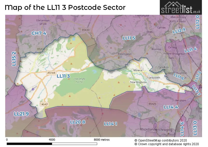
The LL11 3 Postcode shares a border with CH7 4 (LEESWOOD, TREUDDYN, LLANARMON YN IAL), LL11 5 (BRYMBO, BWLCHGWYN, TANYFRON), LL11 6 (NEW BROUGHTON, BRYNTEG, PENTRE BROUGHTON), LL13 7 (WREXHAM, WREXHAM TECHNOLOGY PARK), LL14 4 (Rhostyllen, WREXHAM, Bersham), LL15 2 (LLANFAIR DYFFRYN CLWYD, LLANFWROG, CYFFYLLIOG), LL20 8 (LLANGOLLEN, LLANTYSILIO, EGLWYSEG), LL21 9 (CORWEN, GWYDDELWERN, GLYNDYFRDWY) and LL14 1 (RHOSLLANERCHRUGOG, PONCIAU, JOHNSTOWN).
Map of the LL11 3 Postcode Sector
Explore the LL11 3 postcode sector by using our interactive map.
The sector is within the post town of WREXHAM.
LL11 3 is a postcode sector within the LL11 postcode district which is within the LL Llandudno postcode area.
The Royal Mail delivery office for the LL11 3 postal sector is the Wrexham Delivery Office.
The area of the LL11 3 postcode sector is 20.85 square miles which is 54.00 square kilometres or 13,344.22 square acres.
Your support helps keep this site running!
If you enjoy using this website, consider buying me a coffee to help cover hosting costs.


| L | L | 1 | 1 | - | 3 | X | X |
| L | L | 1 | 1 | Space | 3 | Letter | Letter |
Official List of Streets
Coedpoeth (89 Streets)
WREXHAM (11 Streets)
Llandegla (8 Streets)
Minera (21 Streets)
(1 Streets)
Unofficial Streets or Alternative Spellings
Ffrith
MINERA ROADWREXHAM
HOMESTEAD LANEWrexham Technology Park
CROESNEWYDD ROAD B LINE BERSE LANE BIG JIMS (BLACK GRADE) BLACK CLIMB BLACK ROUTE BLUE ROUTE CLOS LLEWELLYN DAVE THE FOX (BLACK ROUTE) DROPSHORE (RED) FREERIDE TRAIL FROM DUSK TILL DAWN \ THE MICHELIN (RED) GEGIN HILL GEGIN ROAD GREENGATE FARM GWERNYGASEG ROAD HEOL MONA HEOL OFFA LOOP HEOL PENYFELIN HEOL-Y-GELLI HEOL-Y-VRO HERITAGE WAY HILLSBROOK JJS JUMPS JULIAS TRAIL (RED GRADE) LLEWELYN ROAD MIN Y GRAIG MIN-Y-GRUG MINERA MINERAL BRANCH (FORMER ROUTE) NANT LAIS NANT Y GARTH PASS NATRUAL SELECTION (BLACK) NORTHSHORE ISLAND (BLUE GRADE) OLD ROAD BWLCHGWYN OLD ROAD MINERA PARALLEL UNIVERSE (BLACK) PENYGELLI SCHOOL ROAD PENYPALMANT ROAD PIPELINE (RED) PLAS MOSTYN MAWR PLEASANT MOUNT QUEENS PLACE RED CLIMB RED ROUTE RHODFAR BRYN SCHOOL ROAD STRYT Y SCWEIAR STRYTYBYDDEN TALLWRN COURT TOP ROAD TREM-Y-MYNYDD TRUE BLUE (BLUE GRADE) TY BRITH LANE WESTERN GATEWAY WESTERN GATEWAY ROUNDABOUT WOOD COTTAGE LANE WREXHAM AND MINERA LINE (FORMER ROUTE)LLANGOLLEN
HORSESHOE PASSBwlchgwyn
CAE ADAR LANE RUTHIN ROADGwynfryn
FFORDD YR YSGOLWeather Forecast for LL11 3
Weather Forecast for Ruthin
| Time Period | Icon | Description | Temperature | Rain Probability | Wind |
|---|---|---|---|---|---|
| 12:00 to 15:00 | Cloudy | 8.0°C (feels like 6.0°C) | 4.00% | SSE 7 mph | |
| 15:00 to 18:00 | Overcast | 9.0°C (feels like 7.0°C) | 8.00% | SSE 7 mph | |
| 18:00 to 21:00 | Cloudy | 7.0°C (feels like 6.0°C) | 8.00% | SSE 4 mph | |
| 21:00 to 00:00 | Cloudy | 6.0°C (feels like 5.0°C) | 4.00% | S 4 mph |
| Time Period | Icon | Description | Temperature | Rain Probability | Wind |
|---|---|---|---|---|---|
| 00:00 to 03:00 | Cloudy | 6.0°C (feels like 5.0°C) | 4.00% | S 4 mph | |
| 03:00 to 06:00 | Cloudy | 4.0°C (feels like 2.0°C) | 3.00% | SSE 4 mph | |
| 06:00 to 09:00 | Clear night | 3.0°C (feels like 1.0°C) | 1.00% | SSE 7 mph | |
| 09:00 to 12:00 | Cloudy | 4.0°C (feels like 2.0°C) | 4.00% | SSE 7 mph | |
| 12:00 to 15:00 | Cloudy | 9.0°C (feels like 7.0°C) | 5.00% | S 9 mph | |
| 15:00 to 18:00 | Cloudy | 10.0°C (feels like 7.0°C) | 5.00% | S 9 mph | |
| 18:00 to 21:00 | Cloudy | 8.0°C (feels like 5.0°C) | 5.00% | SSE 9 mph | |
| 21:00 to 00:00 | Cloudy | 8.0°C (feels like 5.0°C) | 5.00% | S 11 mph |
| Time Period | Icon | Description | Temperature | Rain Probability | Wind |
|---|---|---|---|---|---|
| 00:00 to 03:00 | Cloudy | 8.0°C (feels like 5.0°C) | 5.00% | S 13 mph | |
| 03:00 to 06:00 | Cloudy | 8.0°C (feels like 5.0°C) | 5.00% | S 13 mph | |
| 06:00 to 09:00 | Cloudy | 9.0°C (feels like 6.0°C) | 6.00% | S 13 mph | |
| 09:00 to 12:00 | Cloudy | 9.0°C (feels like 6.0°C) | 12.00% | S 16 mph | |
| 12:00 to 15:00 | Light rain | 10.0°C (feels like 8.0°C) | 52.00% | SSW 13 mph | |
| 15:00 to 18:00 | Light rain shower (day) | 10.0°C (feels like 7.0°C) | 41.00% | SW 11 mph | |
| 18:00 to 21:00 | Clear night | 8.0°C (feels like 5.0°C) | 5.00% | SW 11 mph | |
| 21:00 to 00:00 | Clear night | 7.0°C (feels like 3.0°C) | 3.00% | WSW 11 mph |
| Time Period | Icon | Description | Temperature | Rain Probability | Wind |
|---|---|---|---|---|---|
| 00:00 to 03:00 | Clear night | 5.0°C (feels like 2.0°C) | 2.00% | WSW 9 mph | |
| 03:00 to 06:00 | Clear night | 5.0°C (feels like 1.0°C) | 1.00% | WSW 9 mph | |
| 06:00 to 09:00 | Clear night | 4.0°C (feels like 1.0°C) | 1.00% | WSW 9 mph | |
| 09:00 to 12:00 | Partly cloudy (day) | 4.0°C (feels like 2.0°C) | 1.00% | WSW 7 mph | |
| 12:00 to 15:00 | Cloudy | 7.0°C (feels like 5.0°C) | 3.00% | W 9 mph | |
| 15:00 to 18:00 | Partly cloudy (day) | 8.0°C (feels like 6.0°C) | 1.00% | WNW 7 mph | |
| 18:00 to 21:00 | Clear night | 4.0°C (feels like 2.0°C) | 1.00% | W 4 mph | |
| 21:00 to 00:00 | Clear night | 2.0°C (feels like 0.0°C) | 1.00% | SW 4 mph |
| Time Period | Icon | Description | Temperature | Rain Probability | Wind |
|---|---|---|---|---|---|
| 00:00 to 03:00 | Clear night | 0.0°C (feels like -1.0°C) | 2.00% | SSW 4 mph | |
| 03:00 to 06:00 | Clear night | 0.0°C (feels like -2.0°C) | 2.00% | S 2 mph | |
| 06:00 to 09:00 | Clear night | -1.0°C (feels like -3.0°C) | 2.00% | S 2 mph | |
| 09:00 to 12:00 | Sunny day | 1.0°C (feels like -1.0°C) | 2.00% | SSE 4 mph | |
| 12:00 to 15:00 | Sunny day | 6.0°C (feels like 4.0°C) | 1.00% | SE 7 mph | |
| 15:00 to 18:00 | Sunny day | 7.0°C (feels like 5.0°C) | 1.00% | ESE 7 mph | |
| 18:00 to 21:00 | Clear night | 3.0°C (feels like 1.0°C) | 1.00% | ESE 7 mph | |
| 21:00 to 00:00 | Clear night | 2.0°C (feels like -1.0°C) | 1.00% | SE 7 mph |
House Prices in the LL11 3 Postcode Sector
| Type of Property | 2018 Average | 2018 Sales | 2017 Average | 2017 Sales | 2016 Average | 2016 Sales | 2015 Average | 2015 Sales |
|---|---|---|---|---|---|---|---|---|
| Detached | £214,577 | 25 | £208,771 | 21 | £192,292 | 37 | £210,727 | 33 |
| Semi-Detached | £140,895 | 44 | £125,574 | 43 | £134,339 | 42 | £124,795 | 22 |
| Terraced | £111,463 | 27 | £97,850 | 15 | £111,094 | 18 | £100,514 | 14 |
| Flats | £98,583 | 6 | £102,731 | 13 | £84,500 | 12 | £79,083 | 9 |
Important Postcodes LL11 3 in the Postcode Sector
LL11 3AW is the postcode for Ysgol Dyffryn Ial, Llandegla
LL11 3HA is the postcode for Penygelli Primary School, Heol Glyndwr, and Penygelli C P School, Heol Glyndwr
LL11 3NB is the postcode for Ysgol Bryn Tabor, Heol Maelor
LL11 3NS is the postcode for Clwydian Community Care NHS Trust, Coedpoeth Clinic, Smithy Road
LL11 3NU is the postcode for Community Development Team Wrexham Borough Council, Castle Road, and Coedpoeth Plas Pentwyn Enterprise Centre, Castle Road
| The LL11 3 Sector is within these Local Authorities |
|
|---|---|
| The LL11 3 Sector is within these Counties |
|
| The LL11 3 Sector is within these Water Company Areas |
|