A wide range of spatial data has been analysed to present this overview of the LE9 3 Postcode sector. If you would like anything added, please contact us.
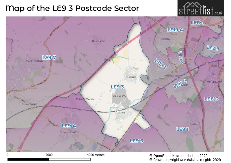
The LE9 3 Croft Postcode Sector
The LE9 3 postcode sector is within the county of Leicestershire.
Did you know? According to the 2021 Census, the LE9 3 postcode sector is home to a bustling 3,928 residents!
Given that each sector allows for 400 unique postcode combinations. Letters C, I, K, M, O and V are not allowed in the last two letters of a postcode. With 78 postcodes already in use, this leaves 322 units available.
The largest settlement in the LE9 3 postal code is Huncote followed by Croft, and Potters Marston.
The LE9 3 Postcode shares a border with LE19 2 (Narborough, Enderby, Littlethorpe), LE19 3 (Narborough), LE9 1 (Cosby), LE9 4 (Stoney Stanton, Sapcote), LE9 6 (Broughton Astley), LE9 7 (Earl Shilton, Thurlaston, Elmesthorpe) and LE19 4 (Enderby, Lubbesthorpe).
Map of the LE9 3 Postcode Sector
Explore the LE9 3 postcode sector by using our interactive map.
The sector is within the post town of LEICESTER.
LE9 3 is a postcode sector within the LE9 postcode district which is within the LE Leicester postcode area.
The Royal Mail delivery office for the LE9 3 postal sector is the Huncote Scale Payment Delivery Office and Croft Scale Payment Delivery Office.
The area of the LE9 3 postcode sector is 3.98 square miles which is 10.31 square kilometres or 2,546.74 square acres.
The LE9 3 postcode sector is crossed by the M69 motorway.
Waterways within the LE9 3 postcode sector include the River Soar.
Your support helps keep this site running!
If you enjoy using this website, consider buying me a coffee to help cover hosting costs.


| L | E | 9 | - | 3 | X | X |
| L | E | 9 | Space | 3 | Letter | Letter |
Official List of Streets
Croft (30 Streets)
Huncote (34 Streets)
(5 Streets)
Potters Marston (1 Streets)
Unofficial Streets or Alternative Spellings
Narborough
HUNCOTE ROADThurlaston
ENDERBY ROAD POTTERS MARSTON LANEBroughton Astley
COVENTRY ROADWeather Forecast for LE9 3
Weather Forecast for Earl Shilton
| Time Period | Icon | Description | Temperature | Rain Probability | Wind |
|---|---|---|---|---|---|
| 00:00 to 03:00 | Light rain | 7.0°C (feels like 4.0°C) | 59.00% | S 13 mph | |
| 03:00 to 06:00 | Heavy rain | 8.0°C (feels like 5.0°C) | 75.00% | S 16 mph | |
| 06:00 to 09:00 | Light rain | 9.0°C (feels like 6.0°C) | 56.00% | S 16 mph | |
| 09:00 to 12:00 | Light rain | 11.0°C (feels like 8.0°C) | 58.00% | S 16 mph | |
| 12:00 to 15:00 | Overcast | 12.0°C (feels like 9.0°C) | 49.00% | SSW 18 mph | |
| 15:00 to 18:00 | Cloudy | 13.0°C (feels like 10.0°C) | 54.00% | SSW 18 mph | |
| 18:00 to 21:00 | Partly cloudy (night) | 11.0°C (feels like 9.0°C) | 8.00% | SSW 11 mph | |
| 21:00 to 00:00 | Cloudy | 11.0°C (feels like 8.0°C) | 6.00% | SSW 11 mph |
| Time Period | Icon | Description | Temperature | Rain Probability | Wind |
|---|---|---|---|---|---|
| 00:00 to 03:00 | Cloudy | 10.0°C (feels like 8.0°C) | 8.00% | S 11 mph | |
| 03:00 to 06:00 | Light rain | 11.0°C (feels like 8.0°C) | 49.00% | S 13 mph | |
| 06:00 to 09:00 | Overcast | 11.0°C (feels like 8.0°C) | 55.00% | S 16 mph | |
| 09:00 to 12:00 | Cloudy | 12.0°C (feels like 8.0°C) | 16.00% | S 18 mph | |
| 12:00 to 15:00 | Cloudy | 13.0°C (feels like 10.0°C) | 8.00% | S 20 mph | |
| 15:00 to 18:00 | Cloudy | 13.0°C (feels like 10.0°C) | 15.00% | S 20 mph | |
| 18:00 to 21:00 | Light rain | 12.0°C (feels like 9.0°C) | 51.00% | SSW 16 mph | |
| 21:00 to 00:00 | Cloudy | 11.0°C (feels like 8.0°C) | 18.00% | SSW 11 mph |
| Time Period | Icon | Description | Temperature | Rain Probability | Wind |
|---|---|---|---|---|---|
| 00:00 to 03:00 | Cloudy | 10.0°C (feels like 7.0°C) | 10.00% | SSW 9 mph | |
| 03:00 to 06:00 | Cloudy | 9.0°C (feels like 7.0°C) | 10.00% | SSW 9 mph | |
| 06:00 to 09:00 | Cloudy | 8.0°C (feels like 6.0°C) | 9.00% | SSW 7 mph | |
| 09:00 to 12:00 | Cloudy | 9.0°C (feels like 7.0°C) | 8.00% | SW 7 mph | |
| 12:00 to 15:00 | Cloudy | 11.0°C (feels like 9.0°C) | 8.00% | SW 9 mph | |
| 15:00 to 18:00 | Partly cloudy (day) | 12.0°C (feels like 10.0°C) | 5.00% | SW 9 mph | |
| 18:00 to 21:00 | Clear night | 9.0°C (feels like 7.0°C) | 2.00% | SSW 7 mph | |
| 21:00 to 00:00 | Clear night | 8.0°C (feels like 5.0°C) | 2.00% | SSW 9 mph |
| Time Period | Icon | Description | Temperature | Rain Probability | Wind |
|---|---|---|---|---|---|
| 00:00 to 03:00 | Clear night | 7.0°C (feels like 4.0°C) | 2.00% | SSW 11 mph | |
| 03:00 to 06:00 | Cloudy | 7.0°C (feels like 3.0°C) | 7.00% | SSW 13 mph | |
| 06:00 to 09:00 | Cloudy | 7.0°C (feels like 4.0°C) | 9.00% | S 16 mph | |
| 09:00 to 12:00 | Cloudy | 9.0°C (feels like 5.0°C) | 18.00% | S 20 mph | |
| 12:00 to 15:00 | Light rain | 11.0°C (feels like 7.0°C) | 52.00% | SSW 22 mph | |
| 15:00 to 18:00 | Light rain | 11.0°C (feels like 8.0°C) | 53.00% | SSW 22 mph | |
| 18:00 to 21:00 | Cloudy | 11.0°C (feels like 8.0°C) | 23.00% | SSW 20 mph | |
| 21:00 to 00:00 | Light rain | 11.0°C (feels like 7.0°C) | 49.00% | SW 20 mph |
Schools and Places of Education Within the LE9 3 Postcode Sector
Croft Church of England Primary School
Academy converter
Brookes Avenue, Leicester, Leicestershire, LE9 3GJ
Head: Miss Felicity Clarke
Ofsted Rating: Requires improvement
Inspection: 2023-09-27 (511 days ago)
Website: Visit Croft Church of England Primary School Website
Phone: 01455282643
Number of Pupils: 133
Huncote Primary School
Academy converter
Denman Lane, Leicester, Leicestershire, LE9 3BS
Head: Mrs Rachel Cumberlidge
Ofsted Rating: Good
Inspection: 2022-03-16 (1071 days ago)
Website: Visit Huncote Primary School Website
Phone: 01162864105
Number of Pupils: 184
House Prices in the LE9 3 Postcode Sector
| Type of Property | 2018 Average | 2018 Sales | 2017 Average | 2017 Sales | 2016 Average | 2016 Sales | 2015 Average | 2015 Sales |
|---|---|---|---|---|---|---|---|---|
| Detached | £307,753 | 19 | £253,079 | 26 | £243,933 | 29 | £224,907 | 30 |
| Semi-Detached | £195,672 | 30 | £186,345 | 20 | £178,797 | 31 | £173,642 | 30 |
| Terraced | £155,317 | 3 | £167,497 | 17 | £135,090 | 5 | £144,557 | 22 |
| Flats | £0 | 0 | £0 | 0 | £189,950 | 1 | £0 | 0 |
Important Postcodes LE9 3 in the Postcode Sector
LE9 3BN is the postcode for Huncote Leisure Centre, Sports Field Lane, Huncote, and The Pavilion, Sportsfield Lane
LE9 3BS is the postcode for BLOCKS A,C, Huncote Primary School, Denman Lane, Huncote Primary School, Denman Lane, and BLOCKS A,C, Huncote Cp School, Denman Lane
LE9 3GE is the postcode for BLOCK A, Leicestershire Highways, Arbor Road
| The LE9 3 Sector is within these Local Authorities |
|
|---|---|
| The LE9 3 Sector is within these Counties |
|
| The LE9 3 Sector is within these Water Company Areas |
|