A wide range of spatial data has been analysed to present this overview of the LE67 1 Postcode sector. If you would like anything added, please contact us.
The LE67 1 postcode sector is within the county of Leicestershire.
Did you know? According to the 2021 Census, the LE67 1 postcode sector is home to a bustling 5,964 residents!
Given that each sector allows for 400 unique postcode combinations. Letters C, I, K, M, O and V are not allowed in the last two letters of a postcode. With 155 postcodes already in use, this leaves 245 units available.
The largest settlement in the LE67 1 postal code is Ellistown followed by Bagworth, and Thornton.
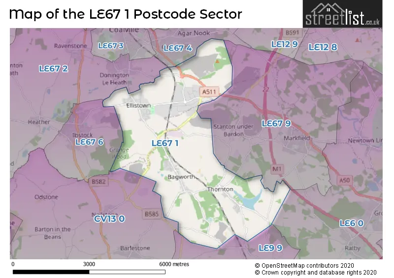
The LE67 1 Postcode shares a border with CV13 0 (Market Bosworth, Barlestone, Nailstone), LE6 0 (Groby, Ratby, Newtown Linford), LE9 9 (Desford, Newbold Verdon, Botcheston), LE67 2 (Hugglescote, Ravenstone, Heather), LE67 4 (COALVILLE), LE67 6 (IBSTOCK) and LE67 9 (MARKFIELD, Stanton Under Bardon, Ulverscroft).
Map of the LE67 1 Postcode Sector
Explore the LE67 1 postcode sector by using our interactive map.
The sector is within the post town of COALVILLE.
LE67 1 is a postcode sector within the LE67 postcode district which is within the LE Leicester postcode area.
The Royal Mail delivery office for the LE67 1 postal sector is the Markfield Scale Payment Delivery Office and Bagworth Scale Payment Delivery Office and Coalville Delivery Office.
The area of the LE67 1 postcode sector is 10.85 square miles which is 28.10 square kilometres or 6,943.39 square acres.
The LE67 1 postcode sector is crossed by the M1 motorway.
Your support helps keep this site running!
If you enjoy using this website, consider buying me a coffee to help cover hosting costs.


| L | E | 6 | 7 | - | 1 | X | X |
| L | E | 6 | 7 | Space | 1 | Letter | Letter |
Official List of Streets
(25 Streets)
Bagworth (32 Streets)
Thornton (19 Streets)
Bardon Hill (17 Streets)
Ellistown (45 Streets)
Unofficial Streets or Alternative Spellings
Botcheston
MARKFIELD LANEDesford
MERRYLEES ROADMARKFIELD
THORNTON LANE ARTHUR TOVELL CRESCENT DROMINTEE ROAD HAROLD MOSELEY WAY HAROLD MOSELY WAY HAWTHORN ROAD HEATHROAD MAIN ROAD MIDLANDS ROAD SAINT CHRISTOPHERS ROADHugglescote
USHERWOOD WAYDonington Le Heath
RICHMOND ROADIBSTOCK
BLACKBERRY LANE LEICESTER ROADWeather Forecast for LE67 1
Weather Forecast for Coalville
| Time Period | Icon | Description | Temperature | Rain Probability | Wind |
|---|---|---|---|---|---|
| 15:00 to 18:00 | Cloudy | 6.0°C (feels like 4.0°C) | 4.00% | WNW 7 mph | |
| 18:00 to 21:00 | Clear night | 4.0°C (feels like 2.0°C) | 0.00% | WNW 4 mph | |
| 21:00 to 00:00 | Clear night | 2.0°C (feels like 0.0°C) | 0.00% | NNW 4 mph |
| Time Period | Icon | Description | Temperature | Rain Probability | Wind |
|---|---|---|---|---|---|
| 00:00 to 03:00 | Clear night | 1.0°C (feels like -1.0°C) | 0.00% | N 4 mph | |
| 03:00 to 06:00 | Clear night | 0.0°C (feels like -2.0°C) | 1.00% | NNE 4 mph | |
| 06:00 to 09:00 | Clear night | 0.0°C (feels like -3.0°C) | 0.00% | NE 4 mph | |
| 09:00 to 12:00 | Fog | 0.0°C (feels like -3.0°C) | 16.00% | NE 4 mph | |
| 12:00 to 15:00 | Mist | 4.0°C (feels like 1.0°C) | 15.00% | ENE 7 mph | |
| 15:00 to 18:00 | Sunny day | 6.0°C (feels like 3.0°C) | 0.00% | ENE 9 mph | |
| 18:00 to 21:00 | Clear night | 3.0°C (feels like 0.0°C) | 0.00% | ENE 9 mph | |
| 21:00 to 00:00 | Partly cloudy (night) | 2.0°C (feels like -2.0°C) | 1.00% | ENE 7 mph |
| Time Period | Icon | Description | Temperature | Rain Probability | Wind |
|---|---|---|---|---|---|
| 00:00 to 03:00 | Cloudy | 1.0°C (feels like -2.0°C) | 7.00% | NE 7 mph | |
| 03:00 to 06:00 | Cloudy | 1.0°C (feels like -3.0°C) | 14.00% | NE 9 mph | |
| 06:00 to 09:00 | Cloudy | 1.0°C (feels like -3.0°C) | 7.00% | NE 11 mph | |
| 09:00 to 12:00 | Cloudy | 2.0°C (feels like -2.0°C) | 7.00% | NE 11 mph | |
| 12:00 to 15:00 | Overcast | 4.0°C (feels like -1.0°C) | 8.00% | ENE 13 mph | |
| 15:00 to 18:00 | Cloudy | 4.0°C (feels like -1.0°C) | 4.00% | ENE 16 mph | |
| 18:00 to 21:00 | Overcast | 2.0°C (feels like -2.0°C) | 8.00% | ENE 13 mph | |
| 21:00 to 00:00 | Overcast | 2.0°C (feels like -3.0°C) | 9.00% | NE 11 mph |
| Time Period | Icon | Description | Temperature | Rain Probability | Wind |
|---|---|---|---|---|---|
| 00:00 to 03:00 | Overcast | 1.0°C (feels like -3.0°C) | 12.00% | NE 11 mph | |
| 03:00 to 06:00 | Overcast | 1.0°C (feels like -3.0°C) | 13.00% | NE 9 mph | |
| 06:00 to 09:00 | Overcast | 1.0°C (feels like -3.0°C) | 15.00% | NE 9 mph | |
| 09:00 to 12:00 | Overcast | 1.0°C (feels like -2.0°C) | 15.00% | NNE 9 mph | |
| 12:00 to 15:00 | Overcast | 3.0°C (feels like -1.0°C) | 14.00% | NE 9 mph | |
| 15:00 to 18:00 | Overcast | 3.0°C (feels like 0.0°C) | 18.00% | NE 9 mph | |
| 18:00 to 21:00 | Overcast | 3.0°C (feels like 0.0°C) | 21.00% | NNE 7 mph | |
| 21:00 to 00:00 | Overcast | 2.0°C (feels like -1.0°C) | 18.00% | NNE 7 mph |
| Time Period | Icon | Description | Temperature | Rain Probability | Wind |
|---|---|---|---|---|---|
| 00:00 to 03:00 | Overcast | 2.0°C (feels like -1.0°C) | 20.00% | NNE 7 mph | |
| 03:00 to 06:00 | Overcast | 2.0°C (feels like -1.0°C) | 13.00% | NNE 7 mph | |
| 06:00 to 09:00 | Overcast | 2.0°C (feels like -1.0°C) | 13.00% | NNE 7 mph | |
| 09:00 to 12:00 | Overcast | 3.0°C (feels like -1.0°C) | 15.00% | NNE 7 mph | |
| 12:00 to 15:00 | Overcast | 4.0°C (feels like 1.0°C) | 11.00% | NE 9 mph | |
| 15:00 to 18:00 | Overcast | 4.0°C (feels like 1.0°C) | 18.00% | NE 11 mph | |
| 18:00 to 21:00 | Overcast | 4.0°C (feels like 0.0°C) | 14.00% | NE 9 mph | |
| 21:00 to 00:00 | Overcast | 3.0°C (feels like -1.0°C) | 12.00% | NE 11 mph |
Schools and Places of Education Within the LE67 1 Postcode Sector
Clovelly House School
Other independent special school
Clovelly, , Leicestershire, LE67 1AP
Head: Mrs Jennifer Collighan
Ofsted Rating: Requires improvement
Inspection: 2023-03-30 (678 days ago)
Website: Visit Clovelly House School Website
Phone: 07853852519
Number of Pupils: 13
Ellistown Community Primary School
Community school
Whitehill Road, Coalville, Leicestershire, LE67 1EN
Head: Mrs Simone Fellows
Ofsted Rating: Good
Inspection: 2023-07-04 (582 days ago)
Website: Visit Ellistown Community Primary School Website
Phone: 01530260301
Number of Pupils: 199
Thornton Primary School
Academy converter
Main Street, Coalville, Leicestershire, LE67 1AH
Head: Mrs Sarah Acton
Ofsted Rating: Good
Inspection: 2023-01-25 (742 days ago)
Website: Visit Thornton Primary School Website
Phone: 01530230250
Number of Pupils: 126
House Prices in the LE67 1 Postcode Sector
| Type of Property | 2018 Average | 2018 Sales | 2017 Average | 2017 Sales | 2016 Average | 2016 Sales | 2015 Average | 2015 Sales |
|---|---|---|---|---|---|---|---|---|
| Detached | £241,374 | 60 | £256,195 | 51 | £224,495 | 50 | £217,874 | 48 |
| Semi-Detached | £180,241 | 33 | £153,360 | 34 | £162,910 | 34 | £149,086 | 36 |
| Terraced | £133,832 | 39 | £131,868 | 31 | £121,837 | 35 | £119,582 | 44 |
| Flats | £0 | 0 | £0 | 0 | £118,164 | 6 | £63,350 | 1 |
Important Postcodes LE67 1 in the Postcode Sector
LE67 1AH is the postcode for Thornton Community Primary School, Main Street
LE67 1EN is the postcode for Ellistown Cp School, Whitehill Road, Ellistown, Ellistown County Primary School, Whitehill Road, BLOCK ABC, Ellistown Cp School, Whitehill Road, and Ellistown Cp School, Whitehill Road
| The LE67 1 Sector is within these Local Authorities |
|
|---|---|
| The LE67 1 Sector is within these Counties |
|
| The LE67 1 Sector is within these Water Company Areas |
|