A wide range of spatial data has been analysed to present this overview of the LE2 2 Postcode sector. If you would like anything added, please contact us.
The LE2 2 Leicester (Knighton) Postcode Sector
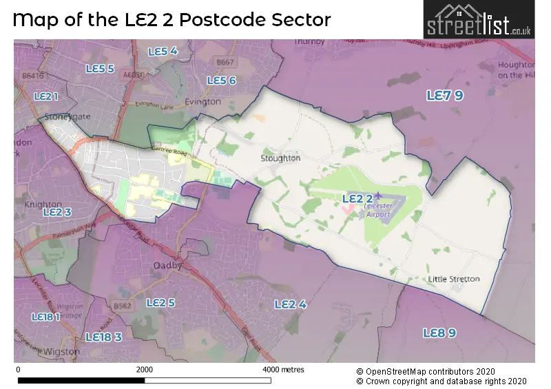
The LE2 2 postcode sector is within the county of Leicestershire.
Did you know? According to the 2021 Census, the LE2 2 postcode sector is home to a bustling 7,269 residents!
Given that each sector allows for 400 unique postcode combinations. Letters C, I, K, M, O and V are not allowed in the last two letters of a postcode. With 130 postcodes already in use, this leaves 270 units available.
The largest settlement in the LE2 2 postal code is LEICESTER followed by Oadby, and Stoughton.
The LE2 2 Postcode shares a border with LE5 5 (LEICESTER), LE5 6 (LEICESTER, Evington), LE7 9 (Scraptoft, Thurnby, Houghton-on-the-Hill), LE2 4 (Oadby), LE2 1 (LEICESTER), LE2 3 (LEICESTER) and LE8 9 (Great Glen, Burton Overy, Newton Harcourt).
Map of the LE2 2 Postcode Sector
Explore the LE2 2 postcode sector by using our interactive map.
The sector is within the post town of LEICESTER.
LE2 2 is a postcode sector within the LE2 postcode district which is within the LE Leicester postcode area.
The Royal Mail delivery office for the LE2 2 postal sector is the Leicester South East Delivery Office.
The area of the LE2 2 postcode sector is 4.71 square miles which is 12.19 square kilometres or 3,011.65 square acres.
Your support helps keep this site running!
If you enjoy using this website, consider buying me a coffee to help cover hosting costs.


| L | E | 2 | - | 2 | X | X |
| L | E | 2 | Space | 2 | Letter | Letter |
Official List of Streets
Oadby (12 Streets)
LEICESTER (47 Streets)
(12 Streets)
Stoughton (5 Streets)
Little Stretton (4 Streets)
Great Stretton (1 Streets)
Unofficial Streets or Alternative Spellings
Houghton-on-the-Hill
HOUGHTON LANE STRETTON LANE BLACKTHHORN LANE CRANBOURNE GARDENS FRANCIS WALK HOME FARM LYNDWOOD COURTGreat Glen
STRETTON ROADLEICESTER
CLARENDON PARK ROAD HIGHWAY ROAD HOLBROOK ROAD KILVERSTONE AVENUE KINGSWAY ROAD KNIGHTON DRIVE KNIGHTON ROAD NEWHAVEN ROAD RATCLIFFE ROAD SHANKLIN DRIVE TOLLER ROAD TURNBURY WAYEvington
CHURCH ROADOadby
LEICESTER ROAD MANOR CLOSE QUICKTHORNS REGENT STREET STOUGHTON ROADWeather Forecast for LE2 2
Weather Forecast for Oadby
| Time Period | Icon | Description | Temperature | Rain Probability | Wind |
|---|---|---|---|---|---|
| 21:00 to 00:00 | Cloudy | 11.0°C (feels like 8.0°C) | 6.00% | SSW 11 mph |
| Time Period | Icon | Description | Temperature | Rain Probability | Wind |
|---|---|---|---|---|---|
| 00:00 to 03:00 | Cloudy | 10.0°C (feels like 8.0°C) | 5.00% | SSW 9 mph | |
| 03:00 to 06:00 | Cloudy | 9.0°C (feels like 8.0°C) | 5.00% | SSW 7 mph | |
| 06:00 to 09:00 | Cloudy | 9.0°C (feels like 7.0°C) | 6.00% | SW 7 mph | |
| 09:00 to 12:00 | Cloudy | 9.0°C (feels like 7.0°C) | 5.00% | SW 7 mph | |
| 12:00 to 15:00 | Cloudy | 11.0°C (feels like 8.0°C) | 6.00% | WSW 11 mph | |
| 15:00 to 18:00 | Partly cloudy (day) | 11.0°C (feels like 9.0°C) | 10.00% | SW 11 mph | |
| 18:00 to 21:00 | Partly cloudy (night) | 9.0°C (feels like 7.0°C) | 3.00% | SSW 9 mph | |
| 21:00 to 00:00 | Clear night | 8.0°C (feels like 5.0°C) | 1.00% | SSW 9 mph |
| Time Period | Icon | Description | Temperature | Rain Probability | Wind |
|---|---|---|---|---|---|
| 00:00 to 03:00 | Clear night | 6.0°C (feels like 3.0°C) | 0.00% | SSW 9 mph | |
| 03:00 to 06:00 | Partly cloudy (night) | 6.0°C (feels like 3.0°C) | 5.00% | S 11 mph | |
| 06:00 to 09:00 | Cloudy | 7.0°C (feels like 3.0°C) | 5.00% | S 16 mph | |
| 09:00 to 12:00 | Cloudy | 8.0°C (feels like 4.0°C) | 5.00% | S 20 mph | |
| 12:00 to 15:00 | Cloudy | 10.0°C (feels like 6.0°C) | 11.00% | S 22 mph | |
| 15:00 to 18:00 | Light rain | 10.0°C (feels like 6.0°C) | 54.00% | SSW 25 mph | |
| 18:00 to 21:00 | Heavy rain | 10.0°C (feels like 6.0°C) | 83.00% | SSW 22 mph | |
| 21:00 to 00:00 | Heavy rain | 10.0°C (feels like 7.0°C) | 83.00% | SSW 20 mph |
| Time Period | Icon | Description | Temperature | Rain Probability | Wind |
|---|---|---|---|---|---|
| 00:00 to 03:00 | Heavy rain | 10.0°C (feels like 7.0°C) | 76.00% | SSW 18 mph | |
| 03:00 to 06:00 | Cloudy | 9.0°C (feels like 6.0°C) | 20.00% | SW 16 mph | |
| 06:00 to 09:00 | Cloudy | 9.0°C (feels like 6.0°C) | 15.00% | SW 13 mph | |
| 09:00 to 12:00 | Cloudy | 9.0°C (feels like 6.0°C) | 14.00% | SW 13 mph | |
| 12:00 to 15:00 | Light rain shower (day) | 11.0°C (feels like 8.0°C) | 35.00% | WSW 16 mph | |
| 15:00 to 18:00 | Partly cloudy (day) | 11.0°C (feels like 8.0°C) | 11.00% | WSW 13 mph | |
| 18:00 to 21:00 | Clear night | 9.0°C (feels like 6.0°C) | 6.00% | SW 9 mph | |
| 21:00 to 00:00 | Clear night | 7.0°C (feels like 4.0°C) | 4.00% | SW 9 mph |
| Time Period | Icon | Description | Temperature | Rain Probability | Wind |
|---|---|---|---|---|---|
| 00:00 to 03:00 | Clear night | 6.0°C (feels like 3.0°C) | 5.00% | SW 9 mph | |
| 03:00 to 06:00 | Clear night | 5.0°C (feels like 2.0°C) | 5.00% | WSW 9 mph | |
| 06:00 to 09:00 | Partly cloudy (night) | 4.0°C (feels like 1.0°C) | 6.00% | WSW 9 mph | |
| 09:00 to 12:00 | Cloudy | 6.0°C (feels like 3.0°C) | 9.00% | WSW 9 mph | |
| 12:00 to 15:00 | Cloudy | 8.0°C (feels like 5.0°C) | 14.00% | W 11 mph | |
| 15:00 to 18:00 | Cloudy | 8.0°C (feels like 6.0°C) | 14.00% | W 11 mph | |
| 18:00 to 21:00 | Partly cloudy (night) | 6.0°C (feels like 4.0°C) | 7.00% | W 9 mph | |
| 21:00 to 00:00 | Clear night | 5.0°C (feels like 2.0°C) | 4.00% | W 9 mph |
Schools and Places of Education Within the LE2 2 Postcode Sector
Leicester Islamic Academy
Other independent school
320 London Road, Leicester, Leicestershire, LE2 2PJ
Head: Mrs Tabassum Jakhura
Ofsted Rating: Good
Inspection: 2022-02-24 (1093 days ago)
Website: Visit Leicester Islamic Academy Website
Phone: 01162705343
Number of Pupils: 326
House Prices in the LE2 2 Postcode Sector
| Type of Property | 2018 Average | 2018 Sales | 2017 Average | 2017 Sales | 2016 Average | 2016 Sales | 2015 Average | 2015 Sales |
|---|---|---|---|---|---|---|---|---|
| Detached | £462,502 | 28 | £582,456 | 24 | £468,885 | 24 | £576,843 | 35 |
| Semi-Detached | £305,299 | 22 | £299,650 | 10 | £344,923 | 13 | £325,377 | 13 |
| Terraced | £220,192 | 13 | £212,944 | 9 | £228,309 | 16 | £193,267 | 18 |
| Flats | £117,345 | 42 | £102,469 | 42 | £105,951 | 43 | £101,699 | 41 |
Important Postcodes LE2 2 in the Postcode Sector
LE2 2LG is the postcode for PRESTWOLD BLOCK, John Foster Hall, 15, Manor Road, JOHN O'GAUNT BLOCK, John Foster Hall, 15, Manor Road, GUMLEY BLOCK, John Foster Hall, 15, Manor Road, Lasdun A Block, Stamford Hall, Manor Road, ALLEXTON BLOCK, John Foster Hall, 15, Manor Road, WISTOW & WITHCOTE BLOCK, Gilbert Murray Hall - Study Bedrooms, Gilbert Murray and Stamford, KILBY BLOCK, John Foster Hall, 15, Manor Road, Gilbert Murray Hall - Clivedon, Gilbert Murray and Stamford, Manor Road, Launde Block, Southmeade Court, Gilbert Murray Hall, ASHCROFT HOUSE, John Foster Hall, 15, Manor Road, Lasdun F Block, Stamford Hall, Manor Road, Skeffington Block, Southmeade Court, Gilbert Murray Hall, Stamford Hall - Bowder Court EE/FF, Gilbert Murray and Stamford, Manor Road, Lasdun B Block, Stamford Hall, Manor Road, LAUNDE & LOWESBY BLOCK, Gilbert Murray Hall - Study Bedrooms, Gilbert Murray and Stamford, Somerby Block, Southmeade Court, Gilbert Murray Hall, RAGDALE BLOCK, John Foster Hall, 15, Manor Road, Wistow block, Southmeade Court, Gilbert Murray Hall, FOXTON BLOCK, John Foster Hall, 15, Manor Road, LEIRE BLOCK, John Foster Hall, 15, Manor Road, HUNCOTE BLOCK, John Foster Hall, 15, Manor Road, Lasdun H-J Block, Stamford Hall, Manor Road, DESFORD BLOCK, John Foster Hall, 15, Manor Road, Lasdun G Block, Stamford Hall, Manor Road, EATON BLOCK, John Foster Hall, 15, Manor Road, Stamford Court & Gilbert Murray House, Manor Road, Stamford Court and Gilbert Murray House, Manor Road, NOSELEY BLOCK, John Foster Hall, 15, Manor Road, Lasdun LA Block, Stamford Hall, Manor Road, Lowesby Block, Southmeade Court, Gilbert Murray Hall, CROFT BLOCK, John Foster Hall, 15, Manor Road, Stamford Hall - Bowder Court AA/BB, Gilbert Murray and Stamford, Manor Road, SKEFFINGTON, SOMERBY AND STAPLEFORD BLOCK, Gilbert Murray Hall - Study Bedrooms, Gilbert Murray and Stamford, Lasdun E Block, Stamford Hall, Manor Road, FACILITIES BUILDING AND LAUNDRY BLOCK, John Foster Hall, 15, Manor Road, Gilbert Murray Hall - Shirley Lodge, Gilbert Murray and Stamford, Manor Road, Withcote block, Southmeade Court, Gilbert Murray Hall, Olive Banks House, Gilbert Murray Hall, Manor Road, Lasdun C Block, Stamford Hall, Manor Road, Lasdun D Block, Stamford Hall, Manor Road, Fields House, Gilbert Murray Hall, Manor Road, THE COPPICE, John Foster Hall, 15, Manor Road, Stapleford block, Southmeade Court, Gilbert Murray Hall, Stamford Hall - Bowder Court GG/HH, Gilbert Murray and Stamford, Manor Road, BARKBY BLOCK, John Foster Hall, 15, Manor Road, QUORNDON BLOCK, John Foster Hall, 15, Manor Road, and MEDBOURNE BLOCK, John Foster Hall, 15, Manor Road
LE2 2LL is the postcode for University of Leicester, Sports Centre, University of Leicester, Field House, 40 Manor Road, University of Leicester, Sports Centre, 40 Manor Road, Oadby, and MANOR ROAD SPORTS HALL, University of Leicester, Field House, 40 Manor Road
LE2 2NA is the postcode for BEAUMONT HOUSE, Beaumont Hall, Stoughton Drive South, Knighton Court Block 4, Beaumont Hall, Stoughton Drive South, Knighton Court Block 3, Beaumont Hall, Stoughton Drive South, Glebe Court A, Beaumont Hall, Stoughton Drive South, Knighton Court Block 5, Beaumont Hall, Stoughton Drive South, Glebe Court D, Beaumont Hall, Stoughton Drive South, Knighton Court Block 2, Beaumont Hall, Stoughton Drive South, BLOCK 8, Beaumont Hall, Stoughton Drive South, Glebe Court B/C, Beaumont Hall, Stoughton Drive South, and Knighton Court Block 1, Beaumont Hall, Stoughton Drive South
LE2 2NB is the postcode for THE KNOLL, Digby Hall, Stoughton Drive South, Southmeade, Digby Hall, Stoughton Drive South, Highgrove, Digby Hall, Stoughton Drive South, Inglewood, Digby Hall, Stoughton Drive South, MODERN BLOCKS - ALL, Digby Hall, Stoughton Drive South, and DIGBY HOUSE UNIVERSITY OF LEICESTER, Digby Hall, Stoughton Drive South
LE2 2ND is the postcode for Lasdun Block, University of Leicester, ROSENFELS UNIVERSITY OF LEICESTER, Stamford Hall, Stoughton Drive South, BLOCK H-J, Lasdun Block, University of Leicester, Stamford House Village Hub, Stamford Hall, Stoughton Drive South, and SHIRLEY HOUSE, Stamford Hall, Stoughton Drive South
LE2 2NE is the postcode for STABLE BLOCK, Hastings House, University of Leicester
| The LE2 2 Sector is within these Local Authorities |
|
|---|---|
| The LE2 2 Sector is within these Counties |
|
| The LE2 2 Sector is within these Water Company Areas |
|