A wide range of spatial data has been analysed to present this overview of the LE16 7 Postcode sector. If you would like anything added, please contact us.
The LE16 7 postcode sector stands on the Leicestershire and Northamptonshire border.
Did you know? According to the 2021 Census, the LE16 7 postcode sector is home to a bustling 12,931 residents!
Given that each sector allows for 400 unique postcode combinations. Letters C, I, K, M, O and V are not allowed in the last two letters of a postcode. With 323 postcodes already in use, this leaves 77 units available.
The largest settlement in the LE16 7 postal code is MARKET HARBOROUGH followed by Great Bowden, and Foxton.
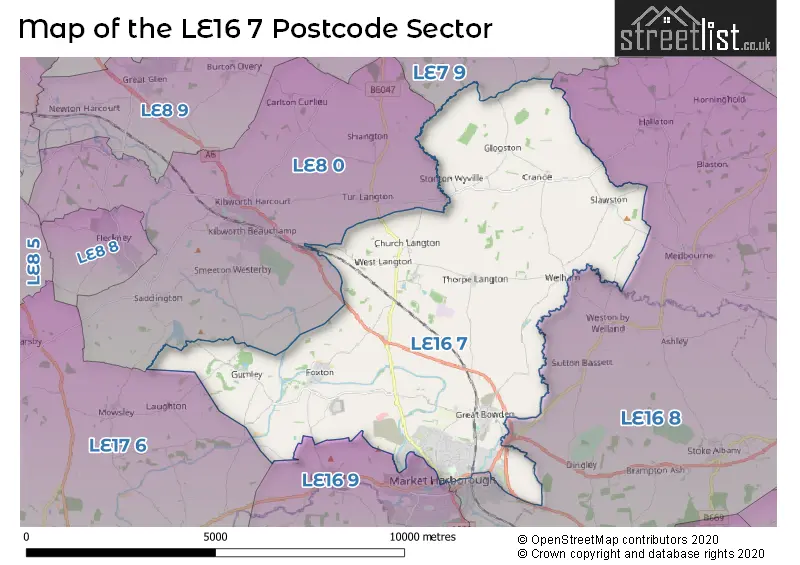
The LE16 7 Postcode shares a border with LE7 9 (Scraptoft, Thurnby, Houghton-on-the-Hill), LE8 0 (Kibworth Beauchamp, Kibworth Harcourt, Smeeton Westerby), LE16 8 (MARKET HARBOROUGH, Cottingham, Great Easton), LE16 9 (MARKET HARBOROUGH, Lubenham, Clipston) and LE17 6 (Husbands Bosworth, North Kilworth, Swinford).
Map of the LE16 7 Postcode Sector
Explore the LE16 7 postcode sector by using our interactive map.
The sector is within the post town of MARKET HARBOROUGH.
LE16 7 is a postcode sector within the LE16 postcode district which is within the LE Leicester postcode area.
The Royal Mail delivery office for the LE16 7 postal sector is the Market Harborough Delivery Office.
The area of the LE16 7 postcode sector is 24.96 square miles which is 64.64 square kilometres or 15,972.36 square acres.
Waterways within the LE16 7 postcode sector include the River Welland, Grand Union Canal Leicester Line, Grand Union Canal Market Harborough Branch, Foxton Inclined Plane upper arm, Foxton Inclined Plane lower arm.
Your support helps keep this site running!
If you enjoy using this website, consider buying me a coffee to help cover hosting costs.


| L | E | 1 | 6 | - | 7 | X | X |
| L | E | 1 | 6 | Space | 7 | Letter | Letter |
Official List of Streets
MARKET HARBOROUGH (155 Streets)
Great Bowden (28 Streets)
(56 Streets)
East Langton (7 Streets)
Slawston (6 Streets)
Glooston (4 Streets)
Welham (4 Streets)
Thorpe Langton (10 Streets)
Stonton Wyville (3 Streets)
Church Langton (7 Streets)
Cranoe (3 Streets)
Foxton (13 Streets)
Lubenham (1 Streets)
Gumley (4 Streets)
West Langton (2 Streets)
Gartree (2 Streets)
Unofficial Streets or Alternative Spellings
Medbourne
SLAWSTON ROADHallaton
GOADBY ROAD HALLATON ROAD ADAM AND EVE STREET BIRCH TREE GARDENS BUNKERS HILL CLARKES BRIDGE GREAT BOWDEN LANE HARRISON ROAD HILLCREST ROUNDABOUT MIDSHIRES WAY PATS BRIDGE POPLARS COURT PUBLIC BRIDLEWAY (A32) PUBLIC BRIDLEWAY (A71) RAINBOW BRIDGE RIDGE VIEW RUSSETT CLOSE RUTLAND WALK (A52) RYLANDS CLOSE SAINT MARYS ROAD THE MILL TOP YARD FARM VICTORIA MEWS WELLAND COURT WELLINGTON WAYMARKET HARBOROUGH
ABBEY STREET COVENTRY ROAD DESBOROUGH ROAD FAIRFIELD ROAD FAIRWAY GORES LANE KETTERING ROAD NORTHAMPTON ROAD SPRINGFIELD STREETTur Langton
CRANOE ROADKibworth Harcourt
HARBOROUGH ROADLubenham
LAUGHTON ROADGreat Stretton
GARTREE ROADSmeeton Westerby
DEBDALE LANE GUMLEY ROADLaughton
GUMLEY ROADWeather Forecast for LE16 7
Weather Forecast for Langton Hall
| Time Period | Icon | Description | Temperature | Rain Probability | Wind |
|---|---|---|---|---|---|
| 18:00 to 21:00 | Overcast | 5.0°C (feels like 2.0°C) | 10.00% | SSE 9 mph | |
| 21:00 to 00:00 | Overcast | 4.0°C (feels like 1.0°C) | 9.00% | SSE 9 mph |
| Time Period | Icon | Description | Temperature | Rain Probability | Wind |
|---|---|---|---|---|---|
| 00:00 to 03:00 | Overcast | 3.0°C (feels like 0.0°C) | 9.00% | S 9 mph | |
| 03:00 to 06:00 | Overcast | 3.0°C (feels like -1.0°C) | 8.00% | SSE 9 mph | |
| 06:00 to 09:00 | Cloudy | 2.0°C (feels like -1.0°C) | 5.00% | SSE 7 mph | |
| 09:00 to 12:00 | Partly cloudy (day) | 2.0°C (feels like -1.0°C) | 1.00% | SSE 7 mph | |
| 12:00 to 15:00 | Sunny day | 5.0°C (feels like 2.0°C) | 1.00% | S 9 mph | |
| 15:00 to 18:00 | Sunny day | 6.0°C (feels like 3.0°C) | 1.00% | SSW 9 mph | |
| 18:00 to 21:00 | Cloudy | 3.0°C (feels like 0.0°C) | 4.00% | SSW 4 mph | |
| 21:00 to 00:00 | Clear night | 2.0°C (feels like -1.0°C) | 1.00% | S 7 mph |
| Time Period | Icon | Description | Temperature | Rain Probability | Wind |
|---|---|---|---|---|---|
| 00:00 to 03:00 | Partly cloudy (night) | 2.0°C (feels like -1.0°C) | 2.00% | SW 7 mph | |
| 03:00 to 06:00 | Overcast | 3.0°C (feels like 0.0°C) | 8.00% | SSW 7 mph | |
| 06:00 to 09:00 | Overcast | 3.0°C (feels like 0.0°C) | 9.00% | SSW 7 mph | |
| 09:00 to 12:00 | Overcast | 4.0°C (feels like 1.0°C) | 9.00% | SSW 9 mph | |
| 12:00 to 15:00 | Cloudy | 6.0°C (feels like 3.0°C) | 5.00% | SSW 11 mph | |
| 15:00 to 18:00 | Cloudy | 8.0°C (feels like 5.0°C) | 5.00% | SSW 11 mph | |
| 18:00 to 21:00 | Cloudy | 6.0°C (feels like 3.0°C) | 5.00% | S 11 mph | |
| 21:00 to 00:00 | Cloudy | 5.0°C (feels like 2.0°C) | 5.00% | SSW 11 mph |
| Time Period | Icon | Description | Temperature | Rain Probability | Wind |
|---|---|---|---|---|---|
| 00:00 to 03:00 | Cloudy | 5.0°C (feels like 2.0°C) | 6.00% | SSW 13 mph | |
| 03:00 to 06:00 | Overcast | 6.0°C (feels like 2.0°C) | 9.00% | SSW 13 mph | |
| 06:00 to 09:00 | Partly cloudy (night) | 5.0°C (feels like 2.0°C) | 3.00% | SSW 13 mph | |
| 09:00 to 12:00 | Cloudy | 6.0°C (feels like 2.0°C) | 6.00% | SSW 13 mph | |
| 12:00 to 15:00 | Overcast | 9.0°C (feels like 6.0°C) | 13.00% | SSW 16 mph | |
| 15:00 to 18:00 | Light rain | 10.0°C (feels like 6.0°C) | 49.00% | SSW 13 mph | |
| 18:00 to 21:00 | Light rain | 8.0°C (feels like 5.0°C) | 51.00% | SW 11 mph | |
| 21:00 to 00:00 | Clear night | 7.0°C (feels like 4.0°C) | 9.00% | WSW 11 mph |
| Time Period | Icon | Description | Temperature | Rain Probability | Wind |
|---|---|---|---|---|---|
| 00:00 to 03:00 | Clear night | 5.0°C (feels like 2.0°C) | 4.00% | WSW 9 mph | |
| 03:00 to 06:00 | Clear night | 4.0°C (feels like 1.0°C) | 1.00% | W 7 mph | |
| 06:00 to 09:00 | Clear night | 2.0°C (feels like -1.0°C) | 2.00% | W 7 mph | |
| 09:00 to 12:00 | Cloudy | 3.0°C (feels like 0.0°C) | 4.00% | W 7 mph | |
| 12:00 to 15:00 | Cloudy | 6.0°C (feels like 4.0°C) | 4.00% | WNW 7 mph | |
| 15:00 to 18:00 | Cloudy | 7.0°C (feels like 5.0°C) | 4.00% | WNW 7 mph | |
| 18:00 to 21:00 | Partly cloudy (night) | 3.0°C (feels like 1.0°C) | 1.00% | WNW 4 mph | |
| 21:00 to 00:00 | Clear night | 2.0°C (feels like 0.0°C) | 1.00% | NNE 4 mph |
Schools and Places of Education Within the LE16 7 Postcode Sector
Church Langton Church of England Primary School
Academy converter
Stonton Road, Market Harborough, Leicestershire, LE16 7SZ
Head: Mrs Lucy Anderson
Ofsted Rating: Good
Inspection: 2022-04-06 (1032 days ago)
Website: Visit Church Langton Church of England Primary School Website
Phone: 01858545237
Number of Pupils: 207
Foxton Primary School
Community school
Gallow Field Road, Market Harborough, Leicestershire, LE16 7QZ
Head: Mr George Norman
Ofsted Rating: Good
Inspection: 2023-02-28 (704 days ago)
Website: Visit Foxton Primary School Website
Phone: 01858545328
Number of Pupils: 84
Great Bowden Academy, A Church of England Primary School
Academy converter
Gunnsbrook Close, Market Harborough, Leicestershire, LE16 7HZ
Head: Mrs Sarah Bishop
Ofsted Rating: Outstanding
Inspection: 2014-09-11 (3796 days ago)
Website: Visit Great Bowden Academy, A Church of England Primary School Website
Phone: 01858463216
Number of Pupils: 123
Meadowdale Primary School
Academy converter
Meadowdale Road, Market Harborough, Leicestershire, LE16 7XQ
Head: Ms Elizabeth Martin
Ofsted Rating: Good
Inspection: 2018-07-03 (2405 days ago)
Website: Visit Meadowdale Primary School Website
Phone: 01858465479
Number of Pupils: 361
Ridgeway Primary Academy
Academy converter
The Ridgeway, Market Harborough, Leicestershire, LE16 7HQ
Head: Mrs Sarah Bishop
Ofsted Rating: Good
Inspection: 2021-09-29 (1221 days ago)
Website: Visit Ridgeway Primary Academy Website
Phone: 01858465800
Number of Pupils: 276
The Robert Smyth Academy
Academy converter
Burnmill Road, Market Harborough, Leicestershire, LE16 7JG
Head: Mr Daniel Cleary
Ofsted Rating: Good
Inspection: 2022-11-30 (794 days ago)
Website: Visit The Robert Smyth Academy Website
Phone: 01858440770
Number of Pupils: 1169
House Prices in the LE16 7 Postcode Sector
| Type of Property | 2018 Average | 2018 Sales | 2017 Average | 2017 Sales | 2016 Average | 2016 Sales | 2015 Average | 2015 Sales |
|---|---|---|---|---|---|---|---|---|
| Detached | £489,908 | 76 | £453,161 | 70 | £418,258 | 77 | £388,150 | 94 |
| Semi-Detached | £281,446 | 56 | £253,001 | 57 | £225,715 | 40 | £218,553 | 56 |
| Terraced | £237,221 | 41 | £250,874 | 46 | £211,593 | 48 | £204,709 | 57 |
| Flats | £215,609 | 35 | £187,711 | 40 | £165,113 | 23 | £209,049 | 42 |
Important Postcodes LE16 7 in the Postcode Sector
LE16 7AA is the postcode for Nags Head, 24 Church Street
LE16 7AG is the postcode for HARBOROUGH DISTRICT COUNCIL, THE SYMINGTON BUILDING, ADAM AND EVE STREET, and Harborough District Council, Council Offices, Adam & Eve Street
LE16 7AU is the postcode for Leicestershire Constabulary, Leicester Road
LE16 7AX is the postcode for Ambulance Station, Leicester Road
LE16 7BN is the postcode for ENDOSCOPY UNIT, St LukeG��s Hospital, 33 Leicester Road, ST LUKE'S TREATMENT CENTRE, St LukeG��s Hospital, 33 Leicester Road, Leicestershire County and Rutland PCT, St Luke's Hospital, 33 Leicester Road, St LukeG��s Hospital, and St LukeG��s Hospital, 33 Leicester Road
LE16 7DR is the postcode for Market Hall, St. Marys Place
LE16 7HQ is the postcode for BLOCKS ACD, Ridgeway Primary School, The Ridgeway
LE16 7HZ is the postcode for Great Bowden Academy, Gunnsbrooke Close
LE16 7JG is the postcode for ART & DESIGN, Robert Smyth Academy, Burnmill Road, L.C.C, SPORTS HALL, Robert Smyth Academy, L.C.C, Robert Smyth Academy, Burnmill Road, ENGLISH BLOCK, Robert Smyth Academy, Burnmill Road, DINING KITCHEN BLOCK, Robert Smyth Academy, Burnmill Road, LANGUAGES, Robert Smyth Academy, Burnmill Road, L.C.C, ART & DESIGN, Robert Smyth Academy, Robert Smyth Academy, Burnmill Road, Robert Symth Academy, Burnmill Road, and SPORTS HALL, Robert Smyth Academy, Burnmill Road
LE16 7PP is the postcode for Royal Mail, Market Harborough Delivery Office, Rockingham Road
LE16 7PQ is the postcode for BLOCK A, Roman Way Day Centre, 36 Roman Way
LE16 7PS is the postcode for More Fitness, Unit M3 Welland Business Park, Valley Way
LE16 7QZ is the postcode for Foxton Primary School, Foxton Road
LE16 7RP is the postcode for H M Prison, Gartree, and GATEHOUSE, H M Prison, Gartree
LE16 7SZ is the postcode for Church Langton C of E Primary School, Stonton Road, Church Langton, and Church Langton C of E Primary School, Stonton Road
LE16 7WB is the postcode for Harborough Innovation Centre, Wellington Way, Airfield Business Park, and Harborough Innovation Centre, Wellington Way
LE16 7XQ is the postcode for Meadowdale Primary School, Meadowdale Road
| The LE16 7 Sector is within these Local Authorities |
|
|---|---|
| The LE16 7 Sector is within these Counties |
|
| The LE16 7 Sector is within these Water Company Areas |
|