A wide range of spatial data has been analysed to present this overview of the LE1 2 Postcode sector. If you would like anything added, please contact us.
The LE1 2 postcode sector is within the county of Leicestershire.
Did you know? According to the 2021 Census, the LE1 2 postcode sector is home to a bustling 5,066 residents!
Given that each sector allows for 400 unique postcode combinations. Letters C, I, K, M, O and V are not allowed in the last two letters of a postcode. With 86 postcodes already in use, this leaves 314 units available.
The LE1 2 postal code covers the settlement of LEICESTER.
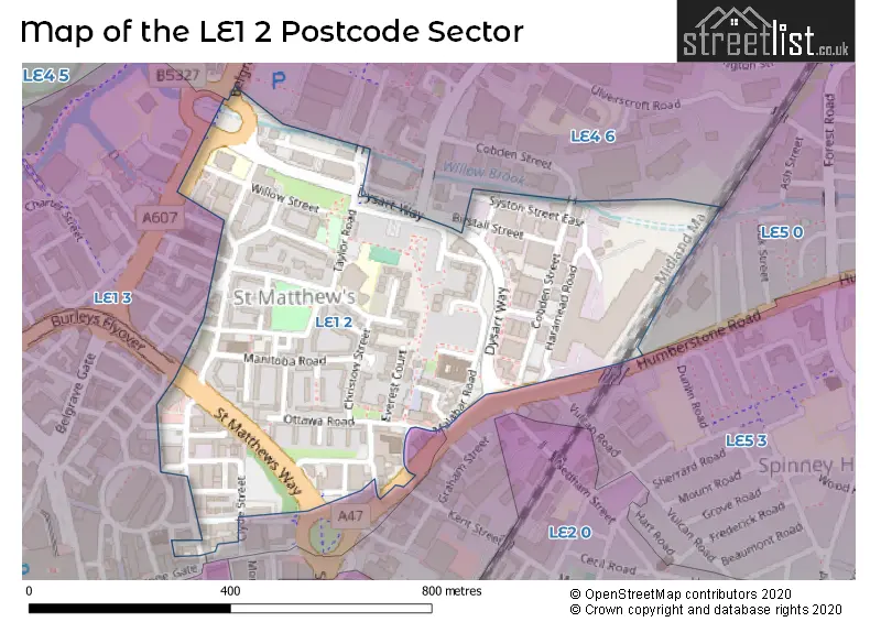
The LE1 2 Postcode shares a border with LE1 3 (LEICESTER), LE4 5 (LEICESTER), LE4 6 (LEICESTER), LE5 0 (LEICESTER) and LE5 3 (LEICESTER).
Map of the LE1 2 Postcode Sector
Explore the LE1 2 postcode sector by using our interactive map.
The sector is within the post town of LEICESTER.
LE1 2 is a postcode sector within the LE1 postcode district which is within the LE Leicester postcode area.
The Royal Mail delivery office for the LE1 2 postal sector is the Leicester Central Delivery Office.
The area of the LE1 2 postcode sector is 0.20 square miles which is 0.52 square kilometres or 127.50 square acres.
Your support helps keep this site running!
If you enjoy using this website, consider buying me a coffee to help cover hosting costs.


| L | E | 1 | - | 2 | X | X |
| L | E | 1 | Space | 2 | Letter | Letter |
Official List of Streets
LEICESTER (49 Streets)
Unofficial Streets or Alternative Spellings
Weather Forecast for LE1 2
Weather Forecast for Leicester
| Time Period | Icon | Description | Temperature | Rain Probability | Wind |
|---|---|---|---|---|---|
| 06:00 to 09:00 | Clear night | 2.0°C (feels like -2.0°C) | 1.00% | NW 7 mph | |
| 09:00 to 12:00 | Sunny day | 2.0°C (feels like -1.0°C) | 0.00% | WNW 9 mph | |
| 12:00 to 15:00 | Sunny day | 6.0°C (feels like 2.0°C) | 0.00% | NW 11 mph | |
| 15:00 to 18:00 | Sunny day | 6.0°C (feels like 4.0°C) | 1.00% | WNW 9 mph | |
| 18:00 to 21:00 | Clear night | 4.0°C (feels like 2.0°C) | 0.00% | WSW 4 mph | |
| 21:00 to 00:00 | Cloudy | 3.0°C (feels like 0.0°C) | 3.00% | WSW 7 mph |
| Time Period | Icon | Description | Temperature | Rain Probability | Wind |
|---|---|---|---|---|---|
| 00:00 to 03:00 | Cloudy | 2.0°C (feels like 0.0°C) | 9.00% | SW 7 mph | |
| 03:00 to 06:00 | Cloudy | 2.0°C (feels like -1.0°C) | 20.00% | SSW 9 mph | |
| 06:00 to 09:00 | Light rain | 3.0°C (feels like 0.0°C) | 58.00% | SSW 9 mph | |
| 09:00 to 12:00 | Light rain | 4.0°C (feels like 1.0°C) | 49.00% | SSW 9 mph | |
| 12:00 to 15:00 | Overcast | 6.0°C (feels like 4.0°C) | 13.00% | NNW 9 mph | |
| 15:00 to 18:00 | Overcast | 7.0°C (feels like 5.0°C) | 10.00% | N 7 mph | |
| 18:00 to 21:00 | Overcast | 5.0°C (feels like 3.0°C) | 10.00% | E 4 mph | |
| 21:00 to 00:00 | Overcast | 4.0°C (feels like 3.0°C) | 9.00% | ESE 4 mph |
| Time Period | Icon | Description | Temperature | Rain Probability | Wind |
|---|---|---|---|---|---|
| 00:00 to 03:00 | Overcast | 4.0°C (feels like 2.0°C) | 9.00% | SSW 4 mph | |
| 03:00 to 06:00 | Overcast | 3.0°C (feels like 1.0°C) | 10.00% | SE 4 mph | |
| 06:00 to 09:00 | Overcast | 3.0°C (feels like 1.0°C) | 10.00% | SE 4 mph | |
| 09:00 to 12:00 | Overcast | 3.0°C (feels like 1.0°C) | 10.00% | SSE 7 mph | |
| 12:00 to 15:00 | Overcast | 6.0°C (feels like 3.0°C) | 9.00% | S 9 mph | |
| 15:00 to 18:00 | Overcast | 7.0°C (feels like 3.0°C) | 9.00% | S 11 mph | |
| 18:00 to 21:00 | Overcast | 5.0°C (feels like 2.0°C) | 8.00% | SSE 9 mph | |
| 21:00 to 00:00 | Cloudy | 4.0°C (feels like 1.0°C) | 6.00% | S 11 mph |
| Time Period | Icon | Description | Temperature | Rain Probability | Wind |
|---|---|---|---|---|---|
| 00:00 to 03:00 | Cloudy | 4.0°C (feels like 0.0°C) | 7.00% | S 11 mph | |
| 03:00 to 06:00 | Cloudy | 4.0°C (feels like 0.0°C) | 10.00% | S 11 mph | |
| 06:00 to 09:00 | Cloudy | 3.0°C (feels like -1.0°C) | 12.00% | S 9 mph | |
| 09:00 to 12:00 | Cloudy | 3.0°C (feels like 0.0°C) | 16.00% | S 9 mph | |
| 12:00 to 15:00 | Cloudy | 6.0°C (feels like 3.0°C) | 17.00% | SSW 9 mph | |
| 15:00 to 18:00 | Partly cloudy (day) | 7.0°C (feels like 4.0°C) | 8.00% | SW 7 mph | |
| 18:00 to 21:00 | Cloudy | 4.0°C (feels like 2.0°C) | 9.00% | SSW 7 mph | |
| 21:00 to 00:00 | Clear night | 3.0°C (feels like 1.0°C) | 4.00% | SW 7 mph |
Schools and Places of Education Within the LE1 2 Postcode Sector
Taylor Road Primary School
Community school
Taylor Road, Leicester, Leicestershire, LE1 2JP
Head: Mrs Anna Grant-Thomas
Ofsted Rating: Good
Inspection: 2019-03-13 (2150 days ago)
Website: Visit Taylor Road Primary School Website
Phone: 01162624597
Number of Pupils: 664
House Prices in the LE1 2 Postcode Sector
| Type of Property | 2018 Average | 2018 Sales | 2017 Average | 2017 Sales | 2016 Average | 2016 Sales | 2015 Average | 2015 Sales |
|---|---|---|---|---|---|---|---|---|
| Detached | £0 | 0 | £0 | 0 | £0 | 0 | £0 | 0 |
| Semi-Detached | £0 | 0 | £0 | 0 | £105,000 | 1 | £0 | 0 |
| Terraced | £0 | 0 | £135,000 | 2 | £0 | 0 | £95,000 | 1 |
| Flats | £0 | 0 | £88,000 | 2 | £71,333 | 3 | £65,500 | 2 |
Important Postcodes LE1 2 in the Postcode Sector
LE1 2GA is the postcode for Surestart, St. Matthews Community Centre
LE1 2HP is the postcode for ABBEY PARK CAMPUS - BLOCK B, The Foundry, Abbey Park Campus
LE1 2JN is the postcode for 6, Taylor Road
LE1 2JP is the postcode for Taylor Road Primary School, 31 Taylor Road
LE1 2LB is the postcode for 2 Cobden Street
LE1 2LG is the postcode for Leicester City Council, Douglas Bader House, Malabar Road
LE1 2NZ is the postcode for Prince Philip House, St. Matthews Health & Community Centre, and Prince Philip House, St. Matthews Health & Community Centre, Malabar Road
LE1 2PD is the postcode for St Matthews Community Centre, 10 Malabar Road, and St. Matthews Centre, 10 Malabar Road
| The LE1 2 Sector is within these Local Authorities |
|
|---|---|
| The LE1 2 Sector is within these Counties |
|
| The LE1 2 Sector is within these Water Company Areas |
|