A wide range of spatial data has been analysed to present this overview of the LA9 5 Postcode sector. If you would like anything added, please contact us.
The LA9 5 postcode sector is within the county of Cumbria.
Did you know? According to the 2021 Census, the LA9 5 postcode sector is home to a bustling 9,604 residents!
Given that each sector allows for 400 unique postcode combinations. Letters C, I, K, M, O and V are not allowed in the last two letters of a postcode. With 211 postcodes already in use, this leaves 189 units available.
The LA9 5 postal code covers the settlement of KENDAL.
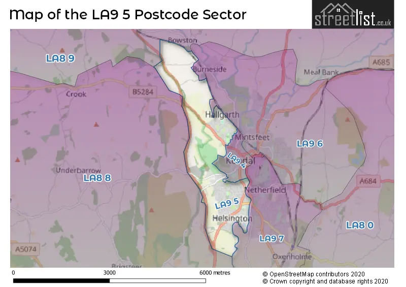
The LA9 5 Postcode shares a border with LA9 7 (KENDAL, Oxenholme, Natland), LA8 8 (Levens, Crosthwaite, Underbarrow), LA8 9 (Staveley, Selside, Burneside), LA9 4 (KENDAL) and LA9 6 (KENDAL, Burneside).
Map of the LA9 5 Postcode Sector
Explore the LA9 5 postcode sector by using our interactive map.
The sector is within the post town of KENDAL.
LA9 5 is a postcode sector within the LA9 postcode district which is within the LA Lancaster postcode area.
The Royal Mail delivery office for the LA9 5 postal sector is the Kendal Delivery Office.
The area of the LA9 5 postcode sector is 2.96 square miles which is 7.66 square kilometres or 1,893.45 square acres.
Waterways within the LA9 5 postcode sector include the River Kent.
Your support helps keep this site running!
If you enjoy using this website, consider buying me a coffee to help cover hosting costs.


| L | A | 9 | - | 5 | X | X |
| L | A | 9 | Space | 5 | Letter | Letter |
Official List of Streets
KENDAL (128 Streets)
(12 Streets)
Helsington (2 Streets)
Unofficial Streets or Alternative Spellings
KENDAL
BANKFIELD ROAD BURNESIDE ROAD CAPTAIN FRENCH LANE COCK & DOLPHIN YARD CROOK ROAD GILLINGGATE GREEN HILL GREEN ROAD HIGH TENTERFELL HORNCOP LANE KENT COURT KENT PLACE LOUND ROAD BLIND BECK BRIDGE BORDERSIDE COLLINFIELD LANE COLONELS WALK DOWKERS LANE FIR TREE RISE GHYLLSIDE GILLING REANE MOSS GHYLL NEW BIGGIN POOR HOUSE LANE RATHERHEATH LANE TCRACK TENTERFIELD THE TRAM YARD 17 YARD 183 YARD 28Burneside
HOLLINS LANEPlantation Bridge
ASHES LANEUnderbarrow
UNDERBARROW ROADWeather Forecast for LA9 5
Weather Forecast for Kendal
| Time Period | Icon | Description | Temperature | Rain Probability | Wind |
|---|---|---|---|---|---|
| 06:00 to 09:00 | Light rain | 8.0°C (feels like 5.0°C) | 65.00% | S 16 mph | |
| 09:00 to 12:00 | Heavy rain | 8.0°C (feels like 4.0°C) | 89.00% | S 16 mph | |
| 12:00 to 15:00 | Heavy rain | 8.0°C (feels like 5.0°C) | 94.00% | SSW 13 mph | |
| 15:00 to 18:00 | Heavy rain | 8.0°C (feels like 5.0°C) | 89.00% | SW 11 mph | |
| 18:00 to 21:00 | Cloudy | 7.0°C (feels like 4.0°C) | 41.00% | SW 13 mph | |
| 21:00 to 00:00 | Partly cloudy (night) | 6.0°C (feels like 2.0°C) | 6.00% | WSW 11 mph |
| Time Period | Icon | Description | Temperature | Rain Probability | Wind |
|---|---|---|---|---|---|
| 00:00 to 03:00 | Partly cloudy (night) | 6.0°C (feels like 2.0°C) | 7.00% | WSW 11 mph | |
| 03:00 to 06:00 | Clear night | 5.0°C (feels like 1.0°C) | 4.00% | WSW 11 mph | |
| 06:00 to 09:00 | Clear night | 5.0°C (feels like 1.0°C) | 4.00% | WSW 9 mph | |
| 09:00 to 12:00 | Partly cloudy (day) | 5.0°C (feels like 2.0°C) | 4.00% | W 9 mph | |
| 12:00 to 15:00 | Sunny day | 7.0°C (feels like 4.0°C) | 6.00% | W 9 mph | |
| 15:00 to 18:00 | Sunny day | 7.0°C (feels like 4.0°C) | 1.00% | W 9 mph | |
| 18:00 to 21:00 | Clear night | 3.0°C (feels like 1.0°C) | 1.00% | WSW 4 mph | |
| 21:00 to 00:00 | Clear night | 2.0°C (feels like 0.0°C) | 1.00% | SSW 2 mph |
| Time Period | Icon | Description | Temperature | Rain Probability | Wind |
|---|---|---|---|---|---|
| 00:00 to 03:00 | Clear night | 1.0°C (feels like 0.0°C) | 3.00% | SE 2 mph | |
| 03:00 to 06:00 | Clear night | 1.0°C (feels like -1.0°C) | 4.00% | E 2 mph | |
| 06:00 to 09:00 | Clear night | 0.0°C (feels like -2.0°C) | 3.00% | E 2 mph | |
| 09:00 to 12:00 | Mist | 1.0°C (feels like -1.0°C) | 11.00% | E 4 mph | |
| 12:00 to 15:00 | Sunny day | 7.0°C (feels like 5.0°C) | 0.00% | ESE 4 mph | |
| 15:00 to 18:00 | Sunny day | 7.0°C (feels like 6.0°C) | 0.00% | ESE 4 mph | |
| 18:00 to 21:00 | Clear night | 2.0°C (feels like 0.0°C) | 0.00% | E 4 mph | |
| 21:00 to 00:00 | Clear night | 1.0°C (feels like -1.0°C) | 0.00% | E 7 mph |
| Time Period | Icon | Description | Temperature | Rain Probability | Wind |
|---|---|---|---|---|---|
| 00:00 to 03:00 | Clear night | 1.0°C (feels like -2.0°C) | 1.00% | E 7 mph | |
| 03:00 to 06:00 | Clear night | 0.0°C (feels like -3.0°C) | 2.00% | E 7 mph | |
| 06:00 to 09:00 | Clear night | 0.0°C (feels like -3.0°C) | 3.00% | E 4 mph | |
| 09:00 to 12:00 | Sunny day | 1.0°C (feels like -1.0°C) | 2.00% | E 4 mph | |
| 12:00 to 15:00 | Sunny day | 5.0°C (feels like 3.0°C) | 1.00% | E 7 mph | |
| 15:00 to 18:00 | Sunny day | 6.0°C (feels like 4.0°C) | 0.00% | E 7 mph | |
| 18:00 to 21:00 | Clear night | 2.0°C (feels like -1.0°C) | 1.00% | E 7 mph | |
| 21:00 to 00:00 | Clear night | 1.0°C (feels like -2.0°C) | 1.00% | E 7 mph |
Schools and Places of Education Within the LA9 5 Postcode Sector
Cambian Whinfell School
Other independent special school
110 Windermere Road, Kendal, Cumbria, LA9 5EZ
Head: Mrs Patricia Sandham
Ofsted Rating: Outstanding
Inspection: 2021-11-04 (1188 days ago)
Website: Visit Cambian Whinfell School Website
Phone: 01539723322
Number of Pupils: 12
Kendal College
Further education
Milnthorpe Road, Kendal, Cumbria, LA9 5AY
Head: Mr Kelvin Nash
Ofsted Rating: Requires improvement
Inspection: 2023-10-13 (480 days ago)
Website: Visit Kendal College Website
Phone: 01539814700
Number of Pupils: 0
St Thomas's CofE Primary School
Voluntary aided school
Kendal Green, Kendal, Cumbria, LA9 5PP
Head: Mrs Maggie Cole
Ofsted Rating: Good
Inspection: 2019-04-25 (2112 days ago)
Website: Visit St Thomas's CofE Primary School Website
Phone: 01539737373
Number of Pupils: 227
Vicarage Park CofE Primary School
Voluntary controlled school
Vicarage Drive, Kendal, Cumbria, LA9 5BP
Head: Mrs Katie Green
Ofsted Rating: Good
Inspection: 2023-02-02 (733 days ago)
Website: Visit Vicarage Park CofE Primary School Website
Phone: 01539735442
Number of Pupils: 101
House Prices in the LA9 5 Postcode Sector
| Type of Property | 2018 Average | 2018 Sales | 2017 Average | 2017 Sales | 2016 Average | 2016 Sales | 2015 Average | 2015 Sales |
|---|---|---|---|---|---|---|---|---|
| Detached | £304,772 | 33 | £325,596 | 28 | £291,322 | 27 | £299,405 | 21 |
| Semi-Detached | £207,195 | 59 | £212,113 | 65 | £207,242 | 61 | £204,955 | 55 |
| Terraced | £194,365 | 55 | £179,809 | 50 | £175,551 | 57 | £161,602 | 61 |
| Flats | £114,539 | 18 | £141,200 | 9 | £91,177 | 21 | £95,542 | 13 |
Important Postcodes LA9 5 in the Postcode Sector
LA9 5AY is the postcode for MAIN BUILDING, Kendal College, Milnthorpe Road, BUILDING SERVICES ENGINEERING, Kendal College, Milnthorpe Road, MAIN BUILDING, Kendal College, Minthorpe Road, CONSTRUCTION CENTRE, Kendal College, Minthorpe Road, and CONSTRUCTION CENTRE, Kendal College, Milnthorpe Road
LA9 5BP is the postcode for Vicarage Park C of E Primary School, Vicarage Drive
LA9 5HB is the postcode for Dean Gibson Catholic Primary School, Hawesmead Avenue
LA9 5JL is the postcode for Riverside House, Wattsfield Road
LA9 5PP is the postcode for St. Thomas C of E School, Kendal Green, and ST THOMAS C OF E SCHOOL, KENDAL GREEN, KENDAL
| The LA9 5 Sector is within these Local Authorities |
|
|---|---|
| The LA9 5 Sector is within these Counties |
|
| The LA9 5 Sector is within these Water Company Areas |
|
Tourist Attractions within the LA9 5 Postcode Area
We found 2 visitor attractions within the LA9 postcode area
| Museum of Lakeland Life |
|---|
| Museums & Art Galleries |
| Museum and / or Art Gallery |
| View Museum of Lakeland Life on Google Maps |
| Abbot Hall Art Gallery |
| Museums & Art Galleries |
| Museum and / or Art Gallery |
| View Abbot Hall Art Gallery on Google Maps |