LA20 Postcode
LA20 is the Postcode District for Broughton-In-Furness in Cumbria
The postcode district is located in the LA Lancaster postal area , LA20 has a population of 1,191 residents according to the 2021 England and Wales Census.
The area of the district is 52.01 square miles (134.70 square kilometers or 33,286.06 acres).
A wide range of spatial data has been analysed to present this overview of LA20. If you would like anything added, please contact us.

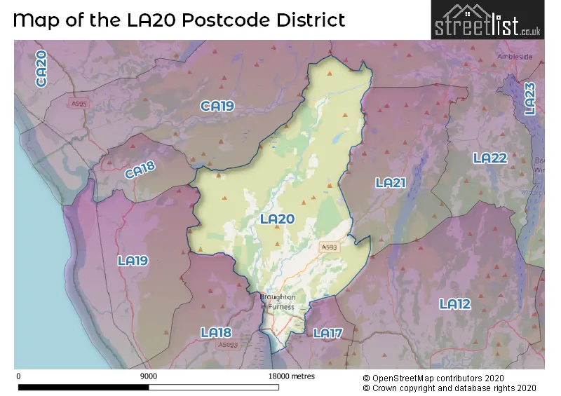
Map of the LA20 Postcode District
Explore the postcode district by using our interactive map.
Circles represent recorded crime; the larger the circle, the higher the crime rates.


Your support helps keep this site running!
If you enjoy using this website, consider buying me a coffee to help cover hosting costs.
Where is the LA20 District?
To give you an idea where the district is located we have created the following table showing nearby towns.
Nearest Towns to LA20
| Town | Distance (miles) | Direction |
|---|---|---|
| Millom | 9.33 | SSW |
| Ulverston | 10.77 | SSE |
| Bowness-on-Windermere | 11.40 | E |
| Ambleside | 11.51 | NE |
| Windermere | 12.13 | ENE |
| Dalton-in-Furness | 12.64 | S |
| Grange-over-Sands | 15.36 | SE |
| Barrow-in-Furness | 15.75 | S |
| Egremont | 16.59 | NW |
| Cleator Moor | 18.07 | NW |
| Kendal | 18.23 | E |
| Keswick | 18.36 | N |
| Whitehaven | 21.49 | NW |
| Carnforth | 22.68 | SE |
| Morecambe | 22.87 | SE |
| Cockermouth | 23.48 | NNW |
| Heysham | 23.60 | SSE |
| Workington | 25.40 | NNW |
| Lancaster | 25.58 | SE |
The post town for this district is BROUGHTON-IN-FURNESS.
Postcode Information for District LA20 (Total Geographical Postcodes: 87)
| Location | Post Town | Sector | Number of Postcodes |
|---|---|---|---|
| BROUGHTON-IN-FURNESS | BROUGHTON-IN-FURNESS | LA20 6 | 52 |
| Woodland | BROUGHTON-IN-FURNESS | LA20 6 | 10 |
| Ulpha | BROUGHTON-IN-FURNESS | LA20 6 | 7 |
| Seathwaite | BROUGHTON-IN-FURNESS | LA20 6 | 5 |
| Foxfield | BROUGHTON-IN-FURNESS | LA20 6 | 5 |
| Broughton Mills | BROUGHTON-IN-FURNESS | LA20 6 | 4 |
| Duddon Bridge | BROUGHTON-IN-FURNESS | LA20 6 | 2 |
| Bank End | BROUGHTON-IN-FURNESS | LA20 6 | 1 |
| Hawthwaite | BROUGHTON-IN-FURNESS | LA20 6 | 1 |
In the LA20 postcode district in Cumbria, the primary settlement is Broughton-in-Furness. Other significant settlements in the district include Bank End, Broughton Mills, Duddon Bridge, Foxfield, Hawthwaite, Seathwaite, Ulpha, and Woodland. The most significant Postal Town in the district is Broughton-in-Furness.
When it comes to local government, postal geography often disregards political borders. However, this district intersects the following councils: the district mostly encompasses the Westmorland and Furness (78 postal codes), and finally, the Cumberland area (10 postal codes).
The largest settlement in the LA20 postal code is BROUGHTON-IN-FURNESS followed by Ulpha, and Seathwaite.
The postcode area has a boundary with The Irish Sea.
The LA20 Postcode shares a border with LA21 (CONISTON, Torver, Haws Bank), LA22 (AMBLESIDE, Grasmere, Hawkshead), LA18 (MILLOM, Haverigg, Silecroft), LA17 (KIRKBY-IN-FURNESS, Grizebeck, Soutergate), LA19 (Bootle, Bootle Station, Waberthwaite) and CA19 (Drigg, Eskdale, HOLMROOK).
Postcode Sectors


Dentists in the LA20 District
No dentists found in this district.
Doctors in the LA20 District
| # | Name | Address | Type | Contact |
|---|---|---|---|---|
| 1 | The Surgery | , BROUGHTON-IN-FURNESS , CUMBRIA , LA20 6EZ | BRANCH SURGERY | |
| 2 | Dr Nl Hall & Dr La Wilson | , C/O THE VICTORY HALL , BROUGHTON-IN-FURNESS , CUMBRIA , LA20 6HN | BRANCH SURGERY |
Chemists in the LA20 District
No Chemists found in this district.
Opticians in the LA20 District
No Opticians found in this district.
Schools in the Sector
Broughton CofE Primary and Nursery School
Phase: Primary
Address: Kepplewray , Broughton-in-Furness
Postcode: LA20 6BJ
Headteacher: Mr Anthony Costa (Headteacher)
Ofsted Rating: Good
Stations in the Sector
Foxfield
CRS Code: FOX
Operator: NT
Line: Cumbrian Coast line
Company: Northern
Accessable Motorway Junctions
M6 J36
Average Driving Time from within the district: 38.15
Average Driving Distance: 30.99
Number of Postcodes that can access the Motorway Junction: 87
M6 J40
Average Driving Time from within the district: 43.04
Average Driving Distance: 31.77
Number of Postcodes that can access the Motorway Junction: 1
M6 J37
Average Driving Time from within the district: 44.96
Average Driving Distance: 35.77
Number of Postcodes that can access the Motorway Junction: 87
M6 J35
Average Driving Time from within the district: 45.60
Average Driving Distance: 38.87
Number of Postcodes that can access the Motorway Junction: 84
M6 J34
Average Driving Time from within the district: 48.82
Average Driving Distance: 42.70
Number of Postcodes that can access the Motorway Junction: 78
M6 J38
Average Driving Time from within the district: 54.28
Average Driving Distance: 36.97
Number of Postcodes that can access the Motorway Junction: 3
M6 J39
Average Driving Time from within the district: 58.06
Average Driving Distance: 39.87
Number of Postcodes that can access the Motorway Junction: 9
Weather Forecast for Broughton Mills
| Time Period | Icon | Description | Temperature | Rain Probability | Wind |
|---|---|---|---|---|---|
| 06:00 to 09:00 | Heavy rain | 9.0°C (feels like 7.0°C) | 83.00% | S 11 mph | |
| 09:00 to 12:00 | Heavy rain | 11.0°C (feels like 8.0°C) | 91.00% | S 16 mph | |
| 12:00 to 15:00 | Heavy rain | 11.0°C (feels like 7.0°C) | 88.00% | SSW 20 mph | |
| 15:00 to 18:00 | Partly cloudy (day) | 10.0°C (feels like 8.0°C) | 33.00% | SSW 13 mph | |
| 18:00 to 21:00 | Partly cloudy (night) | 9.0°C (feels like 6.0°C) | 6.00% | SSW 11 mph | |
| 21:00 to 00:00 | Cloudy | 9.0°C (feels like 6.0°C) | 9.00% | SSW 11 mph |
| Time Period | Icon | Description | Temperature | Rain Probability | Wind |
|---|---|---|---|---|---|
| 00:00 to 03:00 | Cloudy | 9.0°C (feels like 7.0°C) | 13.00% | S 11 mph | |
| 03:00 to 06:00 | Overcast | 10.0°C (feels like 7.0°C) | 15.00% | SSE 13 mph | |
| 06:00 to 09:00 | Heavy rain shower (night) | 11.0°C (feels like 7.0°C) | 68.00% | SSE 20 mph | |
| 09:00 to 12:00 | Heavy rain | 11.0°C (feels like 8.0°C) | 83.00% | SSE 25 mph | |
| 12:00 to 15:00 | Light rain | 12.0°C (feels like 8.0°C) | 61.00% | SSE 25 mph | |
| 15:00 to 18:00 | Light rain shower (day) | 12.0°C (feels like 8.0°C) | 50.00% | S 22 mph | |
| 18:00 to 21:00 | Light rain shower (night) | 10.0°C (feels like 7.0°C) | 42.00% | SSW 18 mph | |
| 21:00 to 00:00 | Cloudy | 9.0°C (feels like 5.0°C) | 18.00% | SSW 16 mph |
| Time Period | Icon | Description | Temperature | Rain Probability | Wind |
|---|---|---|---|---|---|
| 00:00 to 03:00 | Cloudy | 8.0°C (feels like 5.0°C) | 15.00% | SSW 13 mph | |
| 03:00 to 06:00 | Cloudy | 8.0°C (feels like 5.0°C) | 13.00% | SSW 11 mph | |
| 06:00 to 09:00 | Light rain shower (night) | 8.0°C (feels like 5.0°C) | 32.00% | SSW 11 mph | |
| 09:00 to 12:00 | Cloudy | 8.0°C (feels like 6.0°C) | 10.00% | SSW 11 mph | |
| 12:00 to 15:00 | Light rain shower (day) | 10.0°C (feels like 7.0°C) | 28.00% | SW 13 mph | |
| 15:00 to 18:00 | Sunny day | 10.0°C (feels like 7.0°C) | 7.00% | SW 11 mph | |
| 18:00 to 21:00 | Clear night | 8.0°C (feels like 5.0°C) | 2.00% | SSW 9 mph | |
| 21:00 to 00:00 | Clear night | 8.0°C (feels like 5.0°C) | 2.00% | S 11 mph |
| Time Period | Icon | Description | Temperature | Rain Probability | Wind |
|---|---|---|---|---|---|
| 00:00 to 03:00 | Cloudy | 7.0°C (feels like 4.0°C) | 11.00% | S 13 mph | |
| 03:00 to 06:00 | Cloudy | 8.0°C (feels like 4.0°C) | 17.00% | S 18 mph | |
| 06:00 to 09:00 | Light rain | 8.0°C (feels like 4.0°C) | 56.00% | SSE 22 mph | |
| 09:00 to 12:00 | Heavy rain | 9.0°C (feels like 4.0°C) | 86.00% | S 27 mph | |
| 12:00 to 15:00 | Heavy rain | 10.0°C (feels like 6.0°C) | 88.00% | S 27 mph | |
| 15:00 to 18:00 | Heavy rain shower (day) | 11.0°C (feels like 6.0°C) | 74.00% | SSW 27 mph | |
| 18:00 to 21:00 | Heavy rain shower (night) | 10.0°C (feels like 6.0°C) | 68.00% | SSW 27 mph | |
| 21:00 to 00:00 | Light rain shower (night) | 10.0°C (feels like 6.0°C) | 44.00% | SW 25 mph |
| Postal Sector | Delivery Office |
|---|---|
| LA20 6 | Broughton-in-furness Scale Payment Delivery Office |
| L | A | 2 | 0 | - | X | X | X |
| L | A | 2 | 0 | Space | Numeric | Letter | Letter |
Street List for the LA20 District
Current Monthly Rental Prices
| # Bedrooms | Min Price | Max Price | Avg Price |
|---|---|---|---|
| 6 | £1,500 | £1,500 | £1,500 |
Current House Prices
| # Bedrooms | Min Price | Max Price | Avg Price |
|---|---|---|---|
| 1 | £185,000 | £185,000 | £185,000 |
| 2 | £349,000 | £375,000 | £362,000 |
| 3 | £535,000 | £535,000 | £535,000 |
| 4 | £250,000 | £585,000 | £416,000 |
| 5 | £570,000 | £570,000 | £570,000 |
| 6 | £749,000 | £749,000 | £749,000 |
Estate Agents
| Logo | Name | Brand Name | Address | Contact Number |
|---|---|---|---|---|
 | Ulverston | Poole Townsend | County Square Ulverston LA12 7LZ | 01229 444794 |
 | Ulverston | Corrie and Co Ltd | 14 King Street, Ulverston, LA12 7DZ | 01229 441921 |
 | Ulverston | J H Homes | 2 New Market Street, Ulverston, LA12 7LN | 01229 445004 |
 | Barrow-in-Furness | Poole Townsend | 69-75 Duke Street, Barrow-In-Furness, LA14 1RP | 01229 260973 |
 | Bentham (Nr Lancaster), | Richard Turner & Son | Royal Oak Chambers, Main Street, Bentham (Nr Lancaster), LA2 7HF | 01524 967488 |
Yearly House Price Averages for the District
| Type of Property | 2018 Average | 2018 Sales | 2017 Average | 2017 Sales | 2016 Average | 2016 Sales | 2015 Average | 2015 Sales |
|---|---|---|---|---|---|---|---|---|
| Detached | £259,998 | 2 | £347,045 | 11 | £283,642 | 6 | £296,943 | 7 |
| Semi-Detached | £307,500 | 4 | £500,000 | 1 | £270,079 | 7 | £315,000 | 1 |
| Terraced | £221,167 | 6 | £176,038 | 13 | £184,688 | 8 | £169,243 | 7 |
| Flats | £0 | 0 | £0 | 0 | £0 | 0 | £0 | 0 |