A wide range of spatial data has been analysed to present this overview of the L9 1 Postcode sector. If you would like anything added, please contact us.
The L9 1 postcode sector is within the county of Merseyside.
Did you know? According to the 2021 Census, the L9 1 postcode sector is home to a bustling 6,113 residents!
Given that each sector allows for 400 unique postcode combinations. Letters C, I, K, M, O and V are not allowed in the last two letters of a postcode. With 110 postcodes already in use, this leaves 290 units available.
The largest settlements in the L9 1 postal code are LIVERPOOL and Walton.
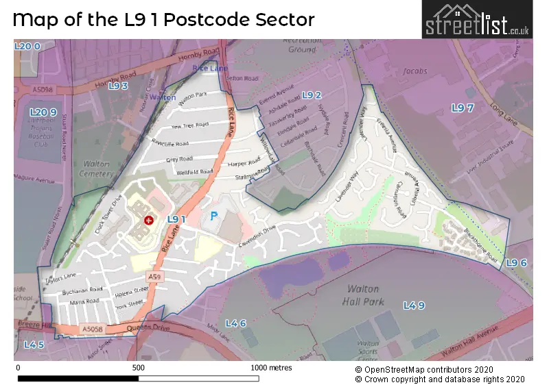
The L9 1 Postcode shares a border with L4 5 (LIVERPOOL, Walton), L4 6 (LIVERPOOL, Walton), L4 9 (LIVERPOOL, Walton), L9 2 (LIVERPOOL, Walton), L9 3 (LIVERPOOL, Walton), L9 7 (LIVERPOOL, Walton), L9 6 (LIVERPOOL, Walton) and L20 9 (BOOTLE).
Map of the L9 1 Postcode Sector
Explore the L9 1 postcode sector by using our interactive map.
The sector is within the post town of LIVERPOOL.
L9 1 is a postcode sector within the L9 postcode district which is within the L Liverpool postcode area.
The Royal Mail delivery office for the L9 1 postal sector is the Walton (l) Delivery Office.
The area of the L9 1 postcode sector is 0.38 square miles which is 0.99 square kilometres or 243.42 square acres.
Your support helps keep this site running!
If you enjoy using this website, consider buying me a coffee to help cover hosting costs.


| L | 9 | - | 1 | X | X |
| L | 9 | Space | 1 | Letter | Letter |
Official List of Streets
LIVERPOOL (63 Streets)
Walton (16 Streets)
Unofficial Streets or Alternative Spellings
LIVERPOOL
ASTOR STREET ELMDALE ROAD EVERED AVENUE HAZELDALE ROAD IMRIE STREET JOULES CLOSE LISTON STREET MAKIN STREET OLNEY STREETWalton
ASHDALE ROAD BROOK ROAD MOOR LANE STUART ROAD GREMBRELL CLOSE LIME TREE CLOSE QUEENS DRIVE FLYOVER QUEENS DRIVE WALTONStoneycroft
QUEENS DRIVEBOOTLE
STUART ROAD NORTHBOOTLE,
BREEZE HILLWeather Forecast for L9 1
Weather Forecast for Everton F.C.
| Time Period | Icon | Description | Temperature | Rain Probability | Wind |
|---|---|---|---|---|---|
| 18:00 to 21:00 | Clear night | 6.0°C (feels like 5.0°C) | 0.00% | W 4 mph | |
| 21:00 to 00:00 | Clear night | 5.0°C (feels like 4.0°C) | 0.00% | SW 2 mph |
| Time Period | Icon | Description | Temperature | Rain Probability | Wind |
|---|---|---|---|---|---|
| 00:00 to 03:00 | Clear night | 3.0°C (feels like 2.0°C) | 0.00% | S 2 mph | |
| 03:00 to 06:00 | Clear night | 2.0°C (feels like 1.0°C) | 0.00% | ESE 4 mph | |
| 06:00 to 09:00 | Fog | 1.0°C (feels like -1.0°C) | 14.00% | ESE 4 mph | |
| 09:00 to 12:00 | Sunny day | 1.0°C (feels like -2.0°C) | 1.00% | SE 4 mph | |
| 12:00 to 15:00 | Sunny day | 4.0°C (feels like 1.0°C) | 0.00% | ESE 7 mph | |
| 15:00 to 18:00 | Sunny day | 7.0°C (feels like 5.0°C) | 0.00% | ESE 7 mph | |
| 18:00 to 21:00 | Clear night | 5.0°C (feels like 2.0°C) | 0.00% | ESE 7 mph | |
| 21:00 to 00:00 | Clear night | 4.0°C (feels like 1.0°C) | 0.00% | E 7 mph |
| Time Period | Icon | Description | Temperature | Rain Probability | Wind |
|---|---|---|---|---|---|
| 00:00 to 03:00 | Clear night | 3.0°C (feels like 0.0°C) | 0.00% | E 7 mph | |
| 03:00 to 06:00 | Clear night | 2.0°C (feels like -1.0°C) | 0.00% | ENE 7 mph | |
| 06:00 to 09:00 | Clear night | 1.0°C (feels like -2.0°C) | 0.00% | ENE 7 mph | |
| 09:00 to 12:00 | Sunny day | 2.0°C (feels like -1.0°C) | 1.00% | ENE 9 mph | |
| 12:00 to 15:00 | Partly cloudy (day) | 5.0°C (feels like 1.0°C) | 0.00% | E 11 mph | |
| 15:00 to 18:00 | Sunny day | 6.0°C (feels like 2.0°C) | 0.00% | ENE 11 mph | |
| 18:00 to 21:00 | Cloudy | 4.0°C (feels like 1.0°C) | 4.00% | ENE 9 mph | |
| 21:00 to 00:00 | Cloudy | 3.0°C (feels like 0.0°C) | 4.00% | ENE 9 mph |
| Time Period | Icon | Description | Temperature | Rain Probability | Wind |
|---|---|---|---|---|---|
| 00:00 to 03:00 | Overcast | 3.0°C (feels like -1.0°C) | 8.00% | ENE 9 mph | |
| 03:00 to 06:00 | Overcast | 2.0°C (feels like -1.0°C) | 7.00% | ENE 7 mph | |
| 06:00 to 09:00 | Cloudy | 2.0°C (feels like -2.0°C) | 4.00% | NE 7 mph | |
| 09:00 to 12:00 | Cloudy | 2.0°C (feels like -1.0°C) | 5.00% | NE 7 mph | |
| 12:00 to 15:00 | Cloudy | 4.0°C (feels like 1.0°C) | 4.00% | NE 9 mph | |
| 15:00 to 18:00 | Overcast | 5.0°C (feels like 2.0°C) | 9.00% | NE 9 mph | |
| 18:00 to 21:00 | Cloudy | 4.0°C (feels like 1.0°C) | 6.00% | ENE 7 mph | |
| 21:00 to 00:00 | Cloudy | 3.0°C (feels like 0.0°C) | 5.00% | NE 7 mph |
| Time Period | Icon | Description | Temperature | Rain Probability | Wind |
|---|---|---|---|---|---|
| 00:00 to 03:00 | Cloudy | 3.0°C (feels like 0.0°C) | 6.00% | NE 7 mph | |
| 03:00 to 06:00 | Cloudy | 3.0°C (feels like 0.0°C) | 7.00% | NE 7 mph | |
| 06:00 to 09:00 | Overcast | 3.0°C (feels like 0.0°C) | 10.00% | ENE 7 mph | |
| 09:00 to 12:00 | Overcast | 3.0°C (feels like 1.0°C) | 10.00% | ENE 7 mph | |
| 12:00 to 15:00 | Cloudy | 5.0°C (feels like 3.0°C) | 9.00% | ENE 7 mph | |
| 15:00 to 18:00 | Cloudy | 6.0°C (feels like 3.0°C) | 14.00% | ENE 9 mph | |
| 18:00 to 21:00 | Overcast | 5.0°C (feels like 2.0°C) | 9.00% | NE 9 mph | |
| 21:00 to 00:00 | Overcast | 4.0°C (feels like 1.0°C) | 8.00% | NE 9 mph |
Schools and Places of Education Within the L9 1 Postcode Sector
Cavendish View School
Other independent special school
99, , , L9 1NB
Head: Headteacher Charlotte Liley
Ofsted Rating: Requires improvement
Inspection: 2022-05-12 (1000 days ago)
Website: Visit Cavendish View School Website
Phone: 01512944899
Number of Pupils: 30
Liverpool Progressive School
Other independent special school
Rice Lane, Liverpool, Merseyside, L9 1NR
Head: Mr Anthony Saleh
Ofsted Rating: Requires improvement
Inspection: 2022-11-24 (804 days ago)
Website: Visit Liverpool Progressive School Website
Phone: 01515254004
Number of Pupils: 21
Northcote Primary School
Community school
Cavendish Drive, Liverpool, Merseyside, L9 1HW
Head: Mr Roy Morgan
Ofsted Rating: Good
Inspection: 2019-10-16 (1939 days ago)
Website: Visit Northcote Primary School Website
Phone: 01512841919
Number of Pupils: 432
House Prices in the L9 1 Postcode Sector
| Type of Property | 2018 Average | 2018 Sales | 2017 Average | 2017 Sales | 2016 Average | 2016 Sales | 2015 Average | 2015 Sales |
|---|---|---|---|---|---|---|---|---|
| Detached | £154,000 | 3 | £145,000 | 1 | £137,500 | 2 | £117,499 | 4 |
| Semi-Detached | £113,242 | 20 | £101,531 | 19 | £110,818 | 17 | £85,950 | 20 |
| Terraced | £71,448 | 45 | £67,328 | 34 | £61,323 | 39 | £71,364 | 28 |
| Flats | £73,893 | 15 | £45,250 | 8 | £45,989 | 9 | £41,278 | 7 |
Important Postcodes L9 1 in the Postcode Sector
L9 1AD is the postcode for Breeze Hill Medical Centre, 1 Rice Lane
L9 1AE is the postcode for Aintree University Hospitals NHS Foundation Trust, Walton Hospital
L9 1DG is the postcode for The Lancaster Centre, 170 Rice Lane
L9 1EP is the postcode for Mersey Care NHS Trust, Clock View Hospital, 2a Oakhouse Park, and Mersey Care NHS Trust, Clock View Hospital, 2a Oakhouse Park, Walton
L9 1HW is the postcode for Northcote Cp School, Cavendish Drive
| The L9 1 Sector is within these Local Authorities |
|
|---|---|
| The L9 1 Sector is within these Counties |
|
| The L9 1 Sector is within these Water Company Areas |
|