A wide range of spatial data has been analysed to present this overview of the L7 8 Postcode sector. If you would like anything added, please contact us.
The L7 8 Liverpool (Fairfield) Postcode Sector
The L7 8 postcode sector is within the county of Merseyside.
Did you know? According to the 2021 Census, the L7 8 postcode sector is home to a bustling 3,889 residents!
Given that each sector allows for 400 unique postcode combinations. Letters C, I, K, M, O and V are not allowed in the last two letters of a postcode. With 62 postcodes already in use, this leaves 338 units available.
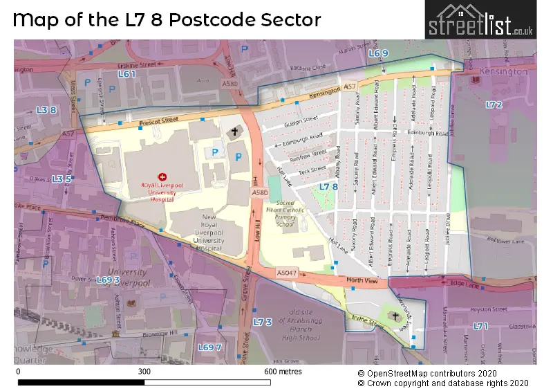
The largest settlement in the L7 8 postal code is LIVERPOOL followed by Kensington, and Edge Hill.
The L7 8 Postcode shares a border with L6 9 (LIVERPOOL, Kensington), L7 1 (LIVERPOOL, Edge Hill), L3 8 (LIVERPOOL), L3 5 (LIVERPOOL), L6 1 (LIVERPOOL, Erskine Industrial Estate), L7 2 (LIVERPOOL, Edge Hill) and L7 3 (LIVERPOOL, Edge Hill).
Map of the L7 8 Postcode Sector
Explore the L7 8 postcode sector by using our interactive map.
The sector is within the post town of LIVERPOOL.
L7 8 is a postcode sector within the L7 postcode district which is within the L Liverpool postcode area.
The Royal Mail delivery office for the L7 8 postal sector is the Liverpool 6-7.
The area of the L7 8 postcode sector is 0.15 square miles which is 0.39 square kilometres or 96.18 square acres.
Your support helps keep this site running!
If you enjoy using this website, consider buying me a coffee to help cover hosting costs.


| L | 7 | - | 8 | X | X |
| L | 7 | Space | 8 | Letter | Letter |
Official List of Streets
Kensington (6 Streets)
LIVERPOOL (17 Streets)
(12 Streets)
Edge Hill (1 Streets)
Unofficial Streets or Alternative Spellings
Weather Forecast for L7 8
Weather Forecast for Edge Hill
| Time Period | Icon | Description | Temperature | Rain Probability | Wind |
|---|---|---|---|---|---|
| 09:00 to 12:00 | Overcast | 12.0°C (feels like 8.0°C) | 16.00% | SSE 25 mph | |
| 12:00 to 15:00 | Cloudy | 12.0°C (feels like 8.0°C) | 15.00% | SSE 25 mph | |
| 15:00 to 18:00 | Cloudy | 14.0°C (feels like 10.0°C) | 9.00% | SSW 20 mph | |
| 18:00 to 21:00 | Cloudy | 11.0°C (feels like 8.0°C) | 5.00% | SSW 11 mph | |
| 21:00 to 00:00 | Cloudy | 9.0°C (feels like 7.0°C) | 5.00% | S 11 mph |
| Time Period | Icon | Description | Temperature | Rain Probability | Wind |
|---|---|---|---|---|---|
| 00:00 to 03:00 | Cloudy | 8.0°C (feels like 6.0°C) | 4.00% | SSE 9 mph | |
| 03:00 to 06:00 | Cloudy | 8.0°C (feels like 6.0°C) | 5.00% | SSE 7 mph | |
| 06:00 to 09:00 | Cloudy | 8.0°C (feels like 5.0°C) | 5.00% | SSE 9 mph | |
| 09:00 to 12:00 | Partly cloudy (day) | 8.0°C (feels like 6.0°C) | 1.00% | S 7 mph | |
| 12:00 to 15:00 | Partly cloudy (day) | 11.0°C (feels like 9.0°C) | 3.00% | SW 11 mph | |
| 15:00 to 18:00 | Partly cloudy (day) | 11.0°C (feels like 9.0°C) | 5.00% | W 11 mph | |
| 18:00 to 21:00 | Clear night | 9.0°C (feels like 8.0°C) | 0.00% | SSW 7 mph | |
| 21:00 to 00:00 | Clear night | 8.0°C (feels like 5.0°C) | 0.00% | S 9 mph |
| Time Period | Icon | Description | Temperature | Rain Probability | Wind |
|---|---|---|---|---|---|
| 00:00 to 03:00 | Clear night | 7.0°C (feels like 4.0°C) | 0.00% | SSE 11 mph | |
| 03:00 to 06:00 | Cloudy | 7.0°C (feels like 3.0°C) | 4.00% | SSE 13 mph | |
| 06:00 to 09:00 | Cloudy | 8.0°C (feels like 4.0°C) | 5.00% | SSE 18 mph | |
| 09:00 to 12:00 | Cloudy | 9.0°C (feels like 5.0°C) | 8.00% | SSE 25 mph | |
| 12:00 to 15:00 | Light rain | 10.0°C (feels like 6.0°C) | 52.00% | S 27 mph | |
| 15:00 to 18:00 | Heavy rain | 11.0°C (feels like 7.0°C) | 83.00% | S 22 mph | |
| 18:00 to 21:00 | Light rain shower (night) | 11.0°C (feels like 7.0°C) | 51.00% | SSW 20 mph | |
| 21:00 to 00:00 | Clear night | 10.0°C (feels like 7.0°C) | 9.00% | SSW 20 mph |
| Time Period | Icon | Description | Temperature | Rain Probability | Wind |
|---|---|---|---|---|---|
| 00:00 to 03:00 | Partly cloudy (night) | 10.0°C (feels like 6.0°C) | 6.00% | SW 20 mph | |
| 03:00 to 06:00 | Partly cloudy (night) | 9.0°C (feels like 6.0°C) | 6.00% | SW 18 mph | |
| 06:00 to 09:00 | Partly cloudy (night) | 9.0°C (feels like 5.0°C) | 5.00% | SW 16 mph | |
| 09:00 to 12:00 | Sunny day | 9.0°C (feels like 5.0°C) | 6.00% | SW 16 mph | |
| 12:00 to 15:00 | Light rain shower (day) | 10.0°C (feels like 6.0°C) | 32.00% | WSW 16 mph | |
| 15:00 to 18:00 | Sunny day | 10.0°C (feels like 7.0°C) | 8.00% | WSW 13 mph | |
| 18:00 to 21:00 | Clear night | 8.0°C (feels like 6.0°C) | 6.00% | SW 11 mph | |
| 21:00 to 00:00 | Clear night | 8.0°C (feels like 4.0°C) | 3.00% | SW 11 mph |
| Time Period | Icon | Description | Temperature | Rain Probability | Wind |
|---|---|---|---|---|---|
| 00:00 to 03:00 | Clear night | 7.0°C (feels like 4.0°C) | 3.00% | SW 11 mph | |
| 03:00 to 06:00 | Clear night | 6.0°C (feels like 3.0°C) | 5.00% | SW 11 mph | |
| 06:00 to 09:00 | Partly cloudy (night) | 6.0°C (feels like 2.0°C) | 8.00% | WSW 13 mph | |
| 09:00 to 12:00 | Cloudy | 6.0°C (feels like 3.0°C) | 13.00% | W 13 mph | |
| 12:00 to 15:00 | Light rain shower (day) | 7.0°C (feels like 4.0°C) | 31.00% | W 16 mph | |
| 15:00 to 18:00 | Light rain shower (day) | 8.0°C (feels like 4.0°C) | 32.00% | WNW 16 mph | |
| 18:00 to 21:00 | Clear night | 7.0°C (feels like 4.0°C) | 9.00% | W 13 mph | |
| 21:00 to 00:00 | Cloudy | 7.0°C (feels like 4.0°C) | 9.00% | W 11 mph |
Schools and Places of Education Within the L7 8 Postcode Sector
Sacred Heart Catholic Primary School and Nursery
Voluntary aided school
Hall Lane, Liverpool, Merseyside, L7 8TQ
Head: Mrs Joy McCallum
Ofsted Rating: Good
Inspection: 2019-07-03 (2060 days ago)
Website: Visit Sacred Heart Catholic Primary School and Nursery Website
Phone: 01517091782
Number of Pupils: 207
House Prices in the L7 8 Postcode Sector
| Type of Property | 2018 Average | 2018 Sales | 2017 Average | 2017 Sales | 2016 Average | 2016 Sales | 2015 Average | 2015 Sales |
|---|---|---|---|---|---|---|---|---|
| Detached | £0 | 0 | £0 | 0 | £0 | 0 | £115,000 | 1 |
| Semi-Detached | £0 | 0 | £0 | 0 | £140,000 | 1 | £95,000 | 1 |
| Terraced | £132,176 | 62 | £119,139 | 82 | £113,051 | 59 | £102,495 | 59 |
| Flats | £57,857 | 7 | £62,645 | 38 | £20,750 | 4 | £0 | 0 |
Important Postcodes L7 8 in the Postcode Sector
L7 8TQ is the postcode for Sacred Heart RC Primary School, Hall Lane, and Sacred Heart RC Primary School, Hall Lane, Kensington
L7 8TX is the postcode for WILLIAM HENRY DUNCAN BUILDING, University of Liverpool, 6 West Derby Street
L7 8XP is the postcode for DENTAL HOSPITAL, Royal Liverpool and Broadgreen University Hospitals NHS Trust, Royal Liverpool Site, DENTAL HOSPITAL, ROYAL LIVERPOOL SITE, PRESCOT STREET, DUNCAN BUILDING, Royal Liverpool and Broadgreen University Hospitals NHS Trust, Royal Liverpool Site, Royal Liverpool and Broadgreen University Hospitals NHS Trust, Royal Liverpool Site, DUNCAN BUILDING, ROYAL LIVERPOOL SITE, PRESCOT STREET, LINDA MCCARTNEY & EDUCATION CENTRE, Royal Liverpool and Broadgreen University Hospitals NHS Trust, Royal Liverpool Site, WARD BLOCK, ROYAL LIVERPOOL SITE, PRESCOT STREET, LINDA MCCARTNEY & EDUCATION CENTRE, ROYAL LIVERPOOL SITE, PRESCOT STREET, and WARD BLOCK, Royal Liverpool and Broadgreen University Hospitals NHS Trust, Royal Liverpool Site
L7 8XZ is the postcode for Liverpool Life Sciences Accelerator, 1 Daulby Street
L7 8YA is the postcode for Clatterbrdige Cancer Centre, 65 Pembroke Place, and Clatterbridge Cancer Centre Liverpool, 65 Pembroke Place
| The L7 8 Sector is within these Local Authorities |
|
|---|---|
| The L7 8 Sector is within these Counties |
|
| The L7 8 Sector is within these Water Company Areas |
|