
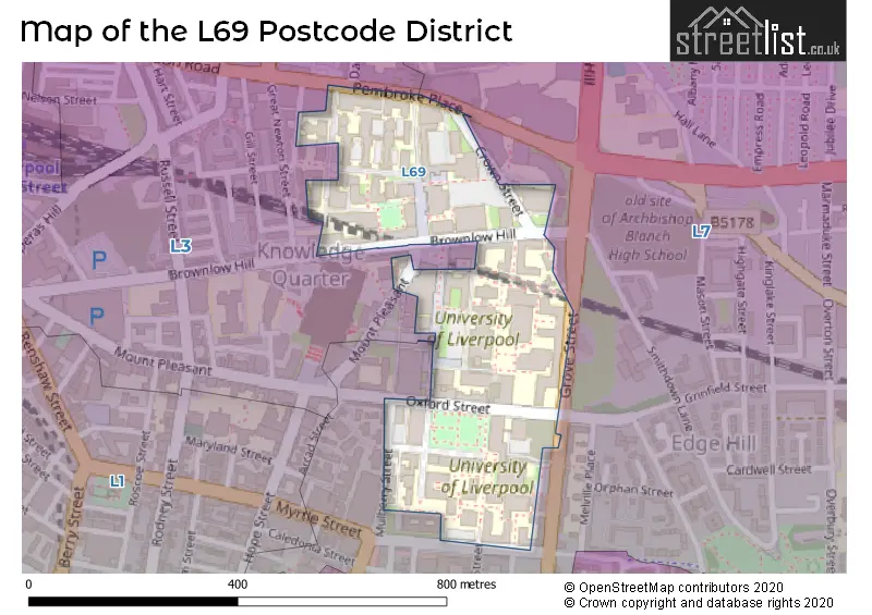
Map of the L69 Postcode District
Explore the postcode district by using our interactive map.
Circles represent recorded crime; the larger the circle, the higher the crime rates.
Your support helps keep this site running!
If you enjoy using this website, consider buying me a coffee to help cover hosting costs.
Where is the L69 District?
To give you an idea where the district is located we have created the following table showing nearby towns.
Nearest Towns to L69
| Town | Distance (miles) | Direction |
|---|---|---|
| Liverpool | 0.63 | WNW |
| Birkenhead | 2.18 | WSW |
| Bootle | 3.60 | NNW |
| Wallasey | 4.31 | WNW |
| Litherland | 4.79 | NNW |
| Bebington | 5.06 | S |
| Crosby | 5.48 | NNW |
| Kirkby | 6.14 | NNE |
| Prescot | 6.81 | ENE |
| Heswall | 7.63 | SW |
| Maghull | 7.71 | N |
| Hoylake | 8.69 | W |
| Neston | 8.96 | SSW |
| Ellesmere Port | 9.15 | SSE |
| West Kirby | 9.32 | WSW |
| Rainford | 9.87 | NE |
| St Helens | 10.00 | ENE |
| Widnes | 10.00 | ESE |
| Runcorn | 10.61 | ESE |
| Formby | 11.23 | NNW |
Post towns for this district are BOOTLE, LIVERPOOL.
Postcode Information for District L69 (Total Geographical Postcodes: 142)
| Location | Post Town | Sector | Number of Postcodes |
|---|---|---|---|
| LIVERPOOL | LIVERPOOL | L69 3 | 109 |
| LIVERPOOL | LIVERPOOL | L69 7 | 33 |
The primary settlement in the L69 postcode district is Liverpool, which is located in Merseyside, England. The most significant post town in this district is also Liverpool.
When it comes to local government, postal geography often disregards political borders. However, this district intersects the following councils: the district mostly encompasses the Liverpool District (B) (229 postal codes), and finally, the Sefton District (B) area (6 postal codes).


Dentists in the L69 District
No dentists found in this district.
Doctors in the L69 District
| # | Name | Address | Type | Contact |
|---|---|---|---|---|
| 1 | Brownlow Health @student Health | , UNIVERSITY OF LIVERPOOL , PEACH STREET , LIVERPOOL , L69 7ZL | BRANCH SURGERY | |
| 2 | Brownlow Group Practice | , 70 PEMBROKE PLACE , LIVERPOOL , L69 3GF | GP PRACTICE |
Chemists in the L69 District
No Chemists found in this district.
Opticians in the L69 District
No Opticians found in this district.
Stations in the Sector
No stations found in this postcode district.
Accessable Motorway Junctions
M57 J7
Average Driving Time from within the district: 8.24
Average Driving Distance: 4.18
Number of Postcodes that can access the Motorway Junction: 6
M58 J1
Average Driving Time from within the district: 8.46
Average Driving Distance: 5.25
Number of Postcodes that can access the Motorway Junction: 1
M57 J6
Average Driving Time from within the district: 9.72
Average Driving Distance: 4.85
Number of Postcodes that can access the Motorway Junction: 6
M57 J4
Average Driving Time from within the district: 10.63
Average Driving Distance: 5.98
Number of Postcodes that can access the Motorway Junction: 9
M57 J5
Average Driving Time from within the district: 12.10
Average Driving Distance: 6.50
Number of Postcodes that can access the Motorway Junction: 17
M62 J5
Average Driving Time from within the district: 12.16
Average Driving Distance: 6.25
Number of Postcodes that can access the Motorway Junction: 189
M53 J1
Average Driving Time from within the district: 13.53
Average Driving Distance: 7.18
Number of Postcodes that can access the Motorway Junction: 194
M53 J2
Average Driving Time from within the district: 16.72
Average Driving Distance: 9.82
Number of Postcodes that can access the Motorway Junction: 149
M53 J3
Average Driving Time from within the district: 17.24
Average Driving Distance: 7.94
Number of Postcodes that can access the Motorway Junction: 186
M53 J4
Average Driving Time from within the district: 18.95
Average Driving Distance: 9.01
Number of Postcodes that can access the Motorway Junction: 178
Weather Forecast for Edge Hill
| Time Period | Icon | Description | Temperature | Rain Probability | Wind |
|---|---|---|---|---|---|
| 12:00 to 15:00 | Overcast | 4.0°C (feels like 2.0°C) | 10.00% | SSE 7 mph | |
| 15:00 to 18:00 | Cloudy | 5.0°C (feels like 2.0°C) | 7.00% | SSE 7 mph | |
| 18:00 to 21:00 | Overcast | 4.0°C (feels like 1.0°C) | 10.00% | SSE 7 mph | |
| 21:00 to 00:00 | Overcast | 3.0°C (feels like 0.0°C) | 10.00% | SE 7 mph |
| Time Period | Icon | Description | Temperature | Rain Probability | Wind |
|---|---|---|---|---|---|
| 00:00 to 03:00 | Overcast | 2.0°C (feels like -1.0°C) | 11.00% | SE 9 mph | |
| 03:00 to 06:00 | Overcast | 1.0°C (feels like -2.0°C) | 10.00% | SE 9 mph | |
| 06:00 to 09:00 | Overcast | 1.0°C (feels like -2.0°C) | 11.00% | SE 7 mph | |
| 09:00 to 12:00 | Overcast | 1.0°C (feels like -2.0°C) | 11.00% | SE 7 mph | |
| 12:00 to 15:00 | Cloudy | 2.0°C (feels like -1.0°C) | 7.00% | SE 7 mph | |
| 15:00 to 18:00 | Cloudy | 3.0°C (feels like 1.0°C) | 6.00% | ESE 7 mph | |
| 18:00 to 21:00 | Overcast | 3.0°C (feels like 0.0°C) | 10.00% | E 4 mph | |
| 21:00 to 00:00 | Overcast | 2.0°C (feels like 0.0°C) | 12.00% | SE 4 mph |
| Time Period | Icon | Description | Temperature | Rain Probability | Wind |
|---|---|---|---|---|---|
| 00:00 to 03:00 | Overcast | 2.0°C (feels like 0.0°C) | 15.00% | SSE 4 mph | |
| 03:00 to 06:00 | Overcast | 2.0°C (feels like 0.0°C) | 16.00% | SSE 7 mph | |
| 06:00 to 09:00 | Overcast | 3.0°C (feels like 0.0°C) | 15.00% | SSW 7 mph | |
| 09:00 to 12:00 | Overcast | 3.0°C (feels like 0.0°C) | 14.00% | S 7 mph | |
| 12:00 to 15:00 | Cloudy | 4.0°C (feels like 1.0°C) | 12.00% | SSE 9 mph | |
| 15:00 to 18:00 | Cloudy | 5.0°C (feels like 3.0°C) | 12.00% | SSW 9 mph | |
| 18:00 to 21:00 | Cloudy | 5.0°C (feels like 2.0°C) | 10.00% | SSW 9 mph | |
| 21:00 to 00:00 | Cloudy | 5.0°C (feels like 1.0°C) | 10.00% | SSW 9 mph |
| Postal Sector | Delivery Office |
|---|---|
| L69 1 | Liverpool 1-3 |
| L69 2 | Liverpool 1-3 |
| L69 3 | Liverpool 1-3 |
| L69 4 | Liverpool 1-3 |
| L69 5 | Liverpool 1-3 |
| L69 6 | Liverpool 1-3 |
| L69 7 | Liverpool 1-3 |
| L69 8 | Liverpool 1-3 |
| L69 9 | Liverpool 1-3 |
| L | 6 | 9 | - | X | X | X |
| L | 6 | 9 | Space | Numeric | Letter | Letter |
Tourist Attractions
We found 3 visitor attractions.
| The Infirmary |
|---|
| Museums & Art Galleries |
| Museum and / or Art Gallery |
| View The Infirmary on Google Maps |
| University of Liverpool Art Gallery |
| Museums & Art Galleries |
| Museum and / or Art Gallery |
| View University of Liverpool Art Gallery on Google Maps |
| Victoria Gallery & Museum |
| Museums & Art Galleries |
| Museum and / or Art Gallery |
| View Victoria Gallery & Museum on Google Maps |
Street List for the L69 District
Current Monthly Rental Prices
| # Bedrooms | Min Price | Max Price | Avg Price |
|---|
Current House Prices
| # Bedrooms | Min Price | Max Price | Avg Price |
|---|
Estate Agents
| Logo | Name | Brand Name | Address | Contact Number |
|---|
Yearly House Price Averages for the District
| Type of Property | 2018 Average | 2018 Sales | 2017 Average | 2017 Sales | 2016 Average | 2016 Sales | 2015 Average | 2015 Sales |
|---|---|---|---|---|---|---|---|---|
| Detached | £0 | 0 | £0 | 0 | £0 | 0 | £0 | 0 |
| Semi-Detached | £0 | 0 | £0 | 0 | £0 | 0 | £0 | 0 |
| Terraced | £0 | 0 | £0 | 0 | £0 | 0 | £0 | 0 |
| Flats | £0 | 0 | £0 | 0 | £0 | 0 | £0 | 0 |