A wide range of spatial data has been analysed to present this overview of the L4 4 Postcode sector. If you would like anything added, please contact us.
The L4 4 postcode sector is within the county of Merseyside.
Did you know? According to the 2021 Census, the L4 4 postcode sector is home to a bustling 4,499 residents!
Given that each sector allows for 400 unique postcode combinations. Letters C, I, K, M, O and V are not allowed in the last two letters of a postcode. With 119 postcodes already in use, this leaves 281 units available.
The largest settlements in the L4 4 postal code are LIVERPOOL and Kirkdale.
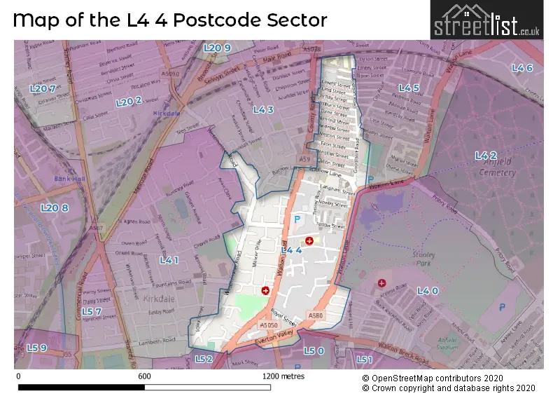
The L4 4 Postcode shares a border with L4 1 (LIVERPOOL, Kirkdale), L5 0 (LIVERPOOL), L4 0 (LIVERPOOL, Walton), L4 3 (LIVERPOOL, Walton), L5 2 (LIVERPOOL, Kirkdale), L4 5 (LIVERPOOL, Walton) and L5 5 (LIVERPOOL).
Map of the L4 4 Postcode Sector
Explore the L4 4 postcode sector by using our interactive map.
The sector is within the post town of LIVERPOOL.
L4 4 is a postcode sector within the L4 postcode district which is within the L Liverpool postcode area.
The Royal Mail delivery office for the L4 4 postal sector is the Liverpool 4-5.
The area of the L4 4 postcode sector is 0.22 square miles which is 0.58 square kilometres or 143.94 square acres.
Your support helps keep this site running!
If you enjoy using this website, consider buying me a coffee to help cover hosting costs.


| L | 4 | - | 4 | X | X |
| L | 4 | Space | 4 | Letter | Letter |
Official List of Streets
LIVERPOOL (73 Streets)
Kirkdale (3 Streets)
Unofficial Streets or Alternative Spellings
LIVERPOOL
ANFIELD ROAD ASKEW STREET BARLOW LANE BRUNSWICK CLOSE CITY ROAD CROYLANDS STREET DUMBARTON STREET DYSON STREET EMERY STREET ESPIN STREET FOLEY STREET NORTH FRODSHAM STREET GOODALL STREET GWLADYS STREET KIRKDALE ROAD LAMBETH ROAD LINTON STREET NETHERFIELD ROAD NORTH NETLEY STREET NOTRE DAME CLOSE ORWELL ROAD RIPON STREET RUMNEY ROAD SELLAR STREET SLEEPERS HILL SMITH STREET UPPERBROOK WAY WALTON BRECK ROAD WITSUN DRIVEKirkdale
AVON CLOSEWalton
COUNTY ROAD CHURNET STREET ST DOMINGO ROADWeather Forecast for L4 4
Weather Forecast for Everton F.C.
| Time Period | Icon | Description | Temperature | Rain Probability | Wind |
|---|---|---|---|---|---|
| 18:00 to 21:00 | Cloudy | 6.0°C (feels like 2.0°C) | 3.00% | SSE 11 mph | |
| 21:00 to 00:00 | Cloudy | 5.0°C (feels like 1.0°C) | 4.00% | SSE 11 mph |
| Time Period | Icon | Description | Temperature | Rain Probability | Wind |
|---|---|---|---|---|---|
| 00:00 to 03:00 | Cloudy | 6.0°C (feels like 2.0°C) | 5.00% | SSE 13 mph | |
| 03:00 to 06:00 | Cloudy | 5.0°C (feels like 1.0°C) | 5.00% | SSE 13 mph | |
| 06:00 to 09:00 | Cloudy | 5.0°C (feels like 0.0°C) | 5.00% | SSE 13 mph | |
| 09:00 to 12:00 | Cloudy | 5.0°C (feels like 1.0°C) | 10.00% | SSE 13 mph | |
| 12:00 to 15:00 | Overcast | 6.0°C (feels like 2.0°C) | 11.00% | SSE 11 mph | |
| 15:00 to 18:00 | Overcast | 7.0°C (feels like 4.0°C) | 15.00% | SSE 9 mph | |
| 18:00 to 21:00 | Overcast | 7.0°C (feels like 4.0°C) | 12.00% | S 7 mph | |
| 21:00 to 00:00 | Cloudy | 6.0°C (feels like 4.0°C) | 5.00% | S 7 mph |
| Time Period | Icon | Description | Temperature | Rain Probability | Wind |
|---|---|---|---|---|---|
| 00:00 to 03:00 | Cloudy | 6.0°C (feels like 3.0°C) | 5.00% | S 7 mph | |
| 03:00 to 06:00 | Cloudy | 5.0°C (feels like 2.0°C) | 4.00% | SSE 9 mph | |
| 06:00 to 09:00 | Cloudy | 4.0°C (feels like 1.0°C) | 4.00% | SSE 9 mph | |
| 09:00 to 12:00 | Cloudy | 4.0°C (feels like 0.0°C) | 4.00% | SSE 11 mph | |
| 12:00 to 15:00 | Cloudy | 7.0°C (feels like 4.0°C) | 4.00% | SSE 11 mph | |
| 15:00 to 18:00 | Cloudy | 9.0°C (feels like 6.0°C) | 4.00% | S 11 mph | |
| 18:00 to 21:00 | Cloudy | 8.0°C (feels like 5.0°C) | 4.00% | S 13 mph | |
| 21:00 to 00:00 | Cloudy | 7.0°C (feels like 3.0°C) | 4.00% | SSE 13 mph |
| Time Period | Icon | Description | Temperature | Rain Probability | Wind |
|---|---|---|---|---|---|
| 00:00 to 03:00 | Cloudy | 7.0°C (feels like 4.0°C) | 5.00% | S 16 mph | |
| 03:00 to 06:00 | Cloudy | 8.0°C (feels like 4.0°C) | 5.00% | S 16 mph | |
| 06:00 to 09:00 | Cloudy | 8.0°C (feels like 4.0°C) | 10.00% | S 16 mph | |
| 09:00 to 12:00 | Cloudy | 8.0°C (feels like 5.0°C) | 16.00% | S 16 mph | |
| 12:00 to 15:00 | Cloudy | 9.0°C (feels like 6.0°C) | 22.00% | SSW 16 mph | |
| 15:00 to 18:00 | Cloudy | 9.0°C (feels like 6.0°C) | 19.00% | SW 13 mph | |
| 18:00 to 21:00 | Clear night | 8.0°C (feels like 5.0°C) | 11.00% | SW 13 mph | |
| 21:00 to 00:00 | Clear night | 7.0°C (feels like 4.0°C) | 6.00% | WSW 16 mph |
| Time Period | Icon | Description | Temperature | Rain Probability | Wind |
|---|---|---|---|---|---|
| 00:00 to 03:00 | Clear night | 7.0°C (feels like 3.0°C) | 2.00% | W 16 mph | |
| 03:00 to 06:00 | Clear night | 6.0°C (feels like 3.0°C) | 2.00% | W 16 mph | |
| 06:00 to 09:00 | Clear night | 6.0°C (feels like 3.0°C) | 3.00% | W 13 mph | |
| 09:00 to 12:00 | Cloudy | 6.0°C (feels like 3.0°C) | 4.00% | WSW 11 mph | |
| 12:00 to 15:00 | Cloudy | 7.0°C (feels like 5.0°C) | 5.00% | WSW 9 mph | |
| 15:00 to 18:00 | Sunny day | 7.0°C (feels like 5.0°C) | 1.00% | WSW 7 mph | |
| 18:00 to 21:00 | Clear night | 6.0°C (feels like 4.0°C) | 1.00% | SSW 7 mph | |
| 21:00 to 00:00 | Clear night | 5.0°C (feels like 2.0°C) | 1.00% | S 7 mph |
Schools and Places of Education Within the L4 4 Postcode Sector
Arnot St Mary CofE Primary School
Voluntary controlled school
Arnot Street, Liverpool, Merseyside, L4 4ED
Head: Mrs Fiona Roper
Ofsted Rating: Good
Inspection: 2022-11-30 (794 days ago)
Website: Visit Arnot St Mary CofE Primary School Website
Phone: 01512861400
Number of Pupils: 439
Everton Free School
Free schools alternative provision
42 Spellow Lane, Liverpool, , L4 4DF
Head: Mr Steven Baker
Ofsted Rating: Good
Inspection: 2018-10-09 (2307 days ago)
Website: Visit Everton Free School Website
Phone: 01513194120
Number of Pupils: 197
House Prices in the L4 4 Postcode Sector
| Type of Property | 2018 Average | 2018 Sales | 2017 Average | 2017 Sales | 2016 Average | 2016 Sales | 2015 Average | 2015 Sales |
|---|---|---|---|---|---|---|---|---|
| Detached | £187,500 | 1 | £0 | 0 | £0 | 0 | £0 | 0 |
| Semi-Detached | £90,000 | 1 | £86,563 | 4 | £0 | 0 | £144,995 | 1 |
| Terraced | £51,550 | 70 | £49,090 | 61 | £46,820 | 60 | £44,874 | 44 |
| Flats | £33,667 | 3 | £44,555 | 6 | £27,667 | 3 | £56,250 | 4 |
Important Postcodes L4 4 in the Postcode Sector
L4 4BE is the postcode for Royal Oak Hotel, 272 Walton Road
L4 4ED is the postcode for Arnot St. Mary Church of England Primary School, Arnot Street, and County Childrens Centre, Arnot Street
L4 4EZ is the postcode for Notre Dame Catholic College, Everton Valley
L4 4PP is the postcode for Bousfield Health Centre, Westminster Road
| The L4 4 Sector is within these Local Authorities |
|
|---|---|
| The L4 4 Sector is within these Counties |
|
| The L4 4 Sector is within these Water Company Areas |
|