A wide range of spatial data has been analysed to present this overview of the L38 1 Postcode sector. If you would like anything added, please contact us.
The L38 1 postcode sector stands on the Lancashire and Merseyside border.
Did you know? According to the 2021 Census, the L38 1 postcode sector is home to a bustling 198 residents!
Given that each sector allows for 400 unique postcode combinations. Letters C, I, K, M, O and V are not allowed in the last two letters of a postcode. With 8 postcodes already in use, this leaves 392 units available.
The L38 1 postal code covers the settlement of LIVERPOOL.
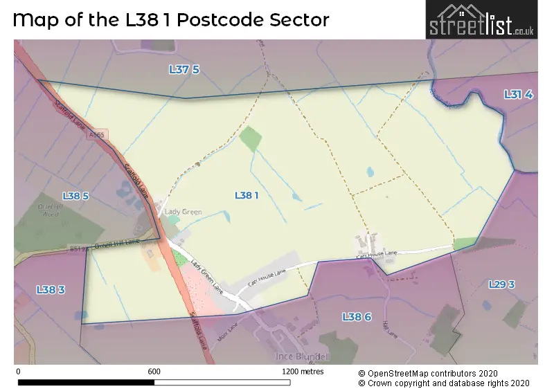
The L38 1 Postcode shares a border with L31 4 (LIVERPOOL, Lydiate, Maghull), L37 5 (LIVERPOOL, Great Altcar), L29 3 (LIVERPOOL), L38 5 (LIVERPOOL, Hightown), L38 6 (Ince Blundell, LIVERPOOL) and L38 3 (Hightown).
Map of the L38 1 Postcode Sector
Explore the L38 1 postcode sector by using our interactive map.
The sector is within the post town of LIVERPOOL.
L38 1 is a postcode sector within the L38 postcode district which is within the L Liverpool postcode area.
The Royal Mail delivery office for the L38 1 postal sector is the Formby Delivery Office.
The area of the L38 1 postcode sector is 0.58 square miles which is 1.50 square kilometres or 370.97 square acres.
Waterways within the L38 1 postcode sector include the River Alt.
Your support helps keep this site running!
If you enjoy using this website, consider buying me a coffee to help cover hosting costs.

| L | 3 | 8 | - | 1 | X | X |
| L | 3 | 8 | Space | 1 | Letter | Letter |
Official List of Streets
LIVERPOOL (4 Streets)
(1 Streets)
Unofficial Streets or Alternative Spellings
Weather Forecast for L38 1
Weather Forecast for Thornton (Merseyside)
| Time Period | Icon | Description | Temperature | Rain Probability | Wind |
|---|---|---|---|---|---|
| 21:00 to 00:00 | Cloudy | 5.0°C (feels like 1.0°C) | 5.00% | SSE 11 mph |
| Time Period | Icon | Description | Temperature | Rain Probability | Wind |
|---|---|---|---|---|---|
| 00:00 to 03:00 | Cloudy | 5.0°C (feels like 2.0°C) | 5.00% | SSE 13 mph | |
| 03:00 to 06:00 | Cloudy | 5.0°C (feels like 1.0°C) | 7.00% | SSE 16 mph | |
| 06:00 to 09:00 | Cloudy | 5.0°C (feels like 0.0°C) | 5.00% | SSE 13 mph | |
| 09:00 to 12:00 | Cloudy | 5.0°C (feels like 1.0°C) | 11.00% | SSE 13 mph | |
| 12:00 to 15:00 | Overcast | 6.0°C (feels like 2.0°C) | 11.00% | SSE 11 mph | |
| 15:00 to 18:00 | Overcast | 7.0°C (feels like 4.0°C) | 15.00% | SSE 7 mph | |
| 18:00 to 21:00 | Overcast | 7.0°C (feels like 5.0°C) | 13.00% | SSE 7 mph | |
| 21:00 to 00:00 | Cloudy | 6.0°C (feels like 4.0°C) | 8.00% | S 7 mph |
| Time Period | Icon | Description | Temperature | Rain Probability | Wind |
|---|---|---|---|---|---|
| 00:00 to 03:00 | Cloudy | 6.0°C (feels like 3.0°C) | 5.00% | S 7 mph | |
| 03:00 to 06:00 | Cloudy | 5.0°C (feels like 2.0°C) | 4.00% | SSE 9 mph | |
| 06:00 to 09:00 | Cloudy | 4.0°C (feels like 1.0°C) | 4.00% | SSE 9 mph | |
| 09:00 to 12:00 | Cloudy | 4.0°C (feels like 1.0°C) | 4.00% | SSE 11 mph | |
| 12:00 to 15:00 | Cloudy | 7.0°C (feels like 5.0°C) | 4.00% | SSE 11 mph | |
| 15:00 to 18:00 | Cloudy | 9.0°C (feels like 6.0°C) | 4.00% | S 11 mph | |
| 18:00 to 21:00 | Cloudy | 8.0°C (feels like 5.0°C) | 4.00% | S 13 mph | |
| 21:00 to 00:00 | Cloudy | 7.0°C (feels like 3.0°C) | 4.00% | SSE 13 mph |
| Time Period | Icon | Description | Temperature | Rain Probability | Wind |
|---|---|---|---|---|---|
| 00:00 to 03:00 | Cloudy | 7.0°C (feels like 4.0°C) | 5.00% | S 13 mph | |
| 03:00 to 06:00 | Cloudy | 8.0°C (feels like 4.0°C) | 5.00% | S 16 mph | |
| 06:00 to 09:00 | Cloudy | 8.0°C (feels like 5.0°C) | 10.00% | S 16 mph | |
| 09:00 to 12:00 | Cloudy | 9.0°C (feels like 5.0°C) | 16.00% | S 16 mph | |
| 12:00 to 15:00 | Cloudy | 9.0°C (feels like 6.0°C) | 22.00% | SSW 16 mph | |
| 15:00 to 18:00 | Cloudy | 9.0°C (feels like 6.0°C) | 19.00% | SW 13 mph | |
| 18:00 to 21:00 | Clear night | 8.0°C (feels like 5.0°C) | 11.00% | SW 13 mph | |
| 21:00 to 00:00 | Clear night | 8.0°C (feels like 4.0°C) | 6.00% | WSW 16 mph |
| Time Period | Icon | Description | Temperature | Rain Probability | Wind |
|---|---|---|---|---|---|
| 00:00 to 03:00 | Clear night | 7.0°C (feels like 3.0°C) | 3.00% | W 16 mph | |
| 03:00 to 06:00 | Clear night | 7.0°C (feels like 3.0°C) | 1.00% | W 16 mph | |
| 06:00 to 09:00 | Clear night | 6.0°C (feels like 3.0°C) | 3.00% | W 13 mph | |
| 09:00 to 12:00 | Cloudy | 6.0°C (feels like 3.0°C) | 4.00% | WSW 11 mph | |
| 12:00 to 15:00 | Cloudy | 7.0°C (feels like 5.0°C) | 4.00% | WSW 9 mph | |
| 15:00 to 18:00 | Sunny day | 7.0°C (feels like 5.0°C) | 1.00% | WSW 7 mph | |
| 18:00 to 21:00 | Clear night | 6.0°C (feels like 4.0°C) | 1.00% | SSW 7 mph | |
| 21:00 to 00:00 | Clear night | 5.0°C (feels like 3.0°C) | 1.00% | S 7 mph |
House Prices in the L38 1 Postcode Sector
| Type of Property | 2018 Average | 2018 Sales | 2017 Average | 2017 Sales | 2016 Average | 2016 Sales | 2015 Average | 2015 Sales |
|---|---|---|---|---|---|---|---|---|
| Detached | £310,000 | 1 | £285,000 | 1 | £0 | 0 | £290,000 | 1 |
| Semi-Detached | £186,000 | 1 | £212,925 | 2 | £207,500 | 2 | £169,000 | 1 |
| Terraced | £0 | 0 | £0 | 0 | £155,000 | 1 | £0 | 0 |
| Flats | £0 | 0 | £0 | 0 | £0 | 0 | £0 | 0 |
| The L38 1 Sector is within these Local Authorities |
|
|---|---|
| The L38 1 Sector is within these Counties |
|
| The L38 1 Sector is within these Water Company Areas |
|