A wide range of spatial data has been analysed to present this overview of the L37 7 Postcode sector. If you would like anything added, please contact us.
The L37 7 postcode sector is within the county of Merseyside.
Did you know? According to the 2021 Census, the L37 7 postcode sector is home to a bustling 3,356 residents!
Given that each sector allows for 400 unique postcode combinations. Letters C, I, K, M, O and V are not allowed in the last two letters of a postcode. With 102 postcodes already in use, this leaves 298 units available.
The L37 7 postal code covers the settlement of Formby.
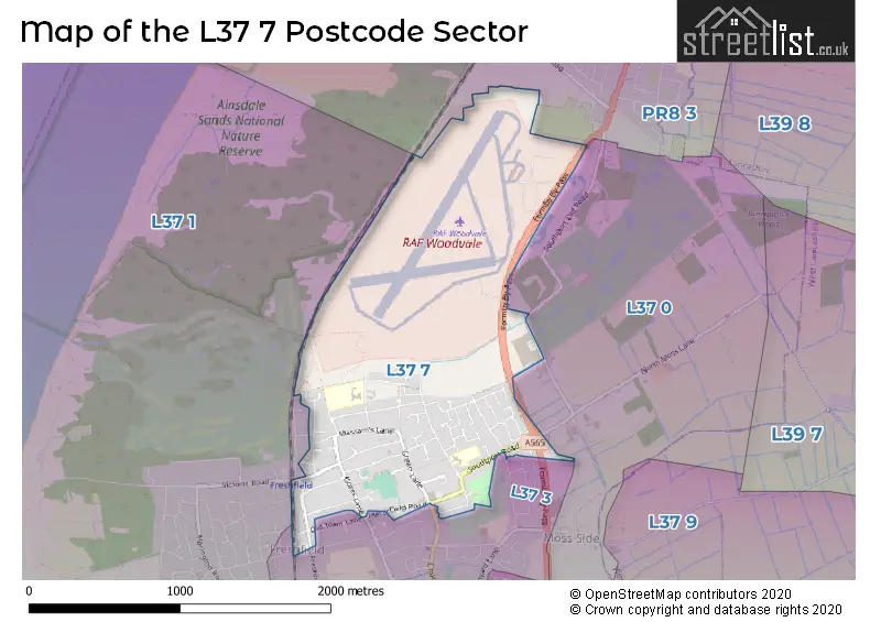
The L37 7 Postcode shares a border with PR8 3 (SOUTHPORT, Ainsdale), L37 0 (Formby), L37 1 (Formby) and L37 3 (Formby).
Map of the L37 7 Postcode Sector
Explore the L37 7 postcode sector by using our interactive map.
The sector is within the post town of LIVERPOOL.
L37 7 is a postcode sector within the L37 postcode district which is within the L Liverpool postcode area.
The Royal Mail delivery office for the L37 7 postal sector is the Formby Delivery Office.
The area of the L37 7 postcode sector is 1.32 square miles which is 3.43 square kilometres or 846.72 square acres.
Your support helps keep this site running!
If you enjoy using this website, consider buying me a coffee to help cover hosting costs.

| L | 3 | 7 | - | 7 | X | X |
| L | 3 | 7 | Space | 7 | Letter | Letter |
Official List of Streets
Formby (55 Streets)
LIVERPOOL (1 Streets)
Unofficial Streets or Alternative Spellings
Ainsdale
LIVERPOOL ROADFormby
BARKFIELD AVENUE BARKFIELD LANE BROAD LANE CHURCH ROAD COLLEGE AVENUE COLLEGE PATH DEANSGATE LANE EIGHT ACRE LANE FORMBY BY-PASS MONTAGU ROAD OLD TOWN LANE SOUTHPORT OLD ROAD STANLAWE ROAD DEANS COURT FISHERMANS PATH LIVERPOOL ROAD MAYFIELD COURT SAINT ANNES CLOSE SAINT ANNES PATH SAINT ANNES ROADWeather Forecast for L37 7
Weather Forecast for Woodvale
| Time Period | Icon | Description | Temperature | Rain Probability | Wind |
|---|---|---|---|---|---|
| 15:00 to 18:00 | Cloudy | 10.0°C (feels like 7.0°C) | 5.00% | S 11 mph | |
| 18:00 to 21:00 | Overcast | 9.0°C (feels like 6.0°C) | 8.00% | S 11 mph | |
| 21:00 to 00:00 | Cloudy | 8.0°C (feels like 5.0°C) | 8.00% | SSE 13 mph |
| Time Period | Icon | Description | Temperature | Rain Probability | Wind |
|---|---|---|---|---|---|
| 00:00 to 03:00 | Cloudy | 8.0°C (feels like 5.0°C) | 7.00% | SSE 11 mph | |
| 03:00 to 06:00 | Cloudy | 9.0°C (feels like 6.0°C) | 30.00% | SSE 13 mph | |
| 06:00 to 09:00 | Overcast | 9.0°C (feels like 6.0°C) | 15.00% | S 13 mph | |
| 09:00 to 12:00 | Cloudy | 10.0°C (feels like 6.0°C) | 15.00% | S 18 mph | |
| 12:00 to 15:00 | Light rain | 10.0°C (feels like 7.0°C) | 56.00% | SSW 16 mph | |
| 15:00 to 18:00 | Heavy rain | 8.0°C (feels like 5.0°C) | 87.00% | SW 13 mph | |
| 18:00 to 21:00 | Clear night | 8.0°C (feels like 4.0°C) | 5.00% | SW 16 mph | |
| 21:00 to 00:00 | Clear night | 7.0°C (feels like 3.0°C) | 3.00% | WSW 16 mph |
| Time Period | Icon | Description | Temperature | Rain Probability | Wind |
|---|---|---|---|---|---|
| 00:00 to 03:00 | Clear night | 7.0°C (feels like 3.0°C) | 1.00% | WSW 16 mph | |
| 03:00 to 06:00 | Clear night | 6.0°C (feels like 2.0°C) | 34.00% | WSW 16 mph | |
| 06:00 to 09:00 | Clear night | 6.0°C (feels like 3.0°C) | 1.00% | W 13 mph | |
| 09:00 to 12:00 | Cloudy | 7.0°C (feels like 3.0°C) | 4.00% | W 13 mph | |
| 12:00 to 15:00 | Cloudy | 7.0°C (feels like 4.0°C) | 4.00% | W 11 mph | |
| 15:00 to 18:00 | Sunny day | 7.0°C (feels like 5.0°C) | 1.00% | WNW 9 mph | |
| 18:00 to 21:00 | Clear night | 6.0°C (feels like 4.0°C) | 1.00% | W 7 mph | |
| 21:00 to 00:00 | Clear night | 5.0°C (feels like 3.0°C) | 1.00% | WSW 4 mph |
| Time Period | Icon | Description | Temperature | Rain Probability | Wind |
|---|---|---|---|---|---|
| 00:00 to 03:00 | Clear night | 4.0°C (feels like 2.0°C) | 1.00% | SSW 4 mph | |
| 03:00 to 06:00 | Clear night | 2.0°C (feels like 0.0°C) | 1.00% | SE 4 mph | |
| 06:00 to 09:00 | Mist | 1.0°C (feels like -2.0°C) | 12.00% | SE 4 mph | |
| 09:00 to 12:00 | Mist | 1.0°C (feels like -2.0°C) | 12.00% | SE 7 mph | |
| 12:00 to 15:00 | Sunny day | 5.0°C (feels like 2.0°C) | 0.00% | SE 7 mph | |
| 15:00 to 18:00 | Sunny day | 7.0°C (feels like 5.0°C) | 0.00% | ESE 7 mph | |
| 18:00 to 21:00 | Clear night | 5.0°C (feels like 2.0°C) | 0.00% | ESE 7 mph | |
| 21:00 to 00:00 | Clear night | 4.0°C (feels like 1.0°C) | 0.00% | ESE 9 mph |
| Time Period | Icon | Description | Temperature | Rain Probability | Wind |
|---|---|---|---|---|---|
| 00:00 to 03:00 | Clear night | 3.0°C (feels like -1.0°C) | 1.00% | ESE 9 mph | |
| 03:00 to 06:00 | Clear night | 2.0°C (feels like -1.0°C) | 1.00% | ESE 9 mph | |
| 06:00 to 09:00 | Clear night | 2.0°C (feels like -2.0°C) | 1.00% | ESE 7 mph | |
| 09:00 to 12:00 | Mist | 2.0°C (feels like -2.0°C) | 13.00% | ESE 7 mph | |
| 12:00 to 15:00 | Sunny day | 4.0°C (feels like 1.0°C) | 1.00% | ESE 9 mph | |
| 15:00 to 18:00 | Sunny day | 6.0°C (feels like 3.0°C) | 1.00% | ESE 9 mph | |
| 18:00 to 21:00 | Clear night | 4.0°C (feels like 2.0°C) | 1.00% | E 7 mph | |
| 21:00 to 00:00 | Clear night | 3.0°C (feels like 0.0°C) | 1.00% | ESE 9 mph |
Schools and Places of Education Within the L37 7 Postcode Sector
Trinity St Peter's CofE Primary School
Voluntary aided school
Paradise Lane, Liverpool, Merseyside, L37 7EJ
Head: Mrs Deborah Pringle
Ofsted Rating: Good
Inspection: 2023-02-10 (724 days ago)
Website: Visit Trinity St Peter's CofE Primary School Website
Phone: 01704876391
Number of Pupils: 239
House Prices in the L37 7 Postcode Sector
| Type of Property | 2018 Average | 2018 Sales | 2017 Average | 2017 Sales | 2016 Average | 2016 Sales | 2015 Average | 2015 Sales |
|---|---|---|---|---|---|---|---|---|
| Detached | £547,479 | 28 | £464,072 | 34 | £422,433 | 30 | £483,348 | 22 |
| Semi-Detached | £299,778 | 16 | £294,070 | 20 | £248,188 | 16 | £234,000 | 7 |
| Terraced | £238,000 | 1 | £195,000 | 4 | £196,000 | 1 | £196,333 | 3 |
| Flats | £190,250 | 2 | £195,629 | 7 | £142,000 | 3 | £187,809 | 13 |
Important Postcodes L37 7 in the Postcode Sector
L37 7AA is the postcode for Royal Mail, Formby Delivery Office, 23 Brows Lane
L37 7EJ is the postcode for Trinity St. Peters Primary School, Paradise Lane
| The L37 7 Sector is within these Local Authorities |
|
|---|---|
| The L37 7 Sector is within these Counties |
|
| The L37 7 Sector is within these Water Company Areas |
|