A wide range of spatial data has been analysed to present this overview of the L35 6 Postcode sector. If you would like anything added, please contact us.
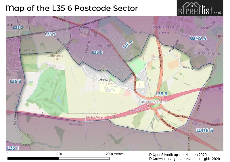
The L35 6 postcode sector stands on the Cheshire and Merseyside border.
Did you know? According to the 2021 Census, the L35 6 postcode sector is home to a bustling 1,483 residents!
Given that each sector allows for 400 unique postcode combinations. Letters C, I, K, M, O and V are not allowed in the last two letters of a postcode. With 46 postcodes already in use, this leaves 354 units available.
The L35 6 postal code covers the settlement of Rainhill.
The L35 6 Postcode shares a border with WA8 5 (WIDNES, Cronton, Bold Heath), L35 3 (Whiston, Halsnead Park), WA9 4 (Clock Face, ST. HELENS, Sutton Manor), L35 0 (Rainhill), L35 4 (Rainhill) and L35 9 (Rainhill).
Map of the L35 6 Postcode Sector
Explore the L35 6 postcode sector by using our interactive map.
The sector is within the post town of PRESCOT.
L35 6 is a postcode sector within the L35 postcode district which is within the L Liverpool postcode area.
The Royal Mail delivery office for the L35 6 postal sector is the Prescot Delivery Office.
The area of the L35 6 postcode sector is 1.76 square miles which is 4.55 square kilometres or 1,123.27 square acres.
The L35 6 postcode sector is crossed by the M62 motorway.
Your support helps keep this site running!
If you enjoy using this website, consider buying me a coffee to help cover hosting costs.

| L | 3 | 5 | - | 6 | X | X |
| L | 3 | 5 | Space | 6 | Letter | Letter |
Official List of Streets
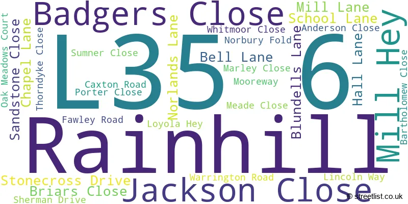
Rainhill (30 Streets)
(4 Streets)
Unofficial Streets or Alternative Spellings
Cronton
HALL LANERainhill
ASHTON AVENUE OLD LANESutton Manor
JUBITS LANEBold Heath
WARRINGTON ROADWeather Forecast for L35 6
Weather Forecast for Sutton Leach
| Time Period | Icon | Description | Temperature | Rain Probability | Wind |
|---|---|---|---|---|---|
| 12:00 to 15:00 | Cloudy | 6.0°C (feels like 3.0°C) | 5.00% | SSE 11 mph | |
| 15:00 to 18:00 | Overcast | 8.0°C (feels like 5.0°C) | 44.00% | SSE 7 mph | |
| 18:00 to 21:00 | Overcast | 7.0°C (feels like 5.0°C) | 45.00% | SSE 4 mph | |
| 21:00 to 00:00 | Cloudy | 7.0°C (feels like 4.0°C) | 9.00% | S 7 mph |
| Time Period | Icon | Description | Temperature | Rain Probability | Wind |
|---|---|---|---|---|---|
| 00:00 to 03:00 | Overcast | 6.0°C (feels like 4.0°C) | 9.00% | S 7 mph | |
| 03:00 to 06:00 | Cloudy | 6.0°C (feels like 4.0°C) | 4.00% | SSW 7 mph | |
| 06:00 to 09:00 | Partly cloudy (night) | 5.0°C (feels like 2.0°C) | 1.00% | S 7 mph | |
| 09:00 to 12:00 | Cloudy | 4.0°C (feels like 1.0°C) | 4.00% | S 9 mph | |
| 12:00 to 15:00 | Cloudy | 8.0°C (feels like 5.0°C) | 5.00% | S 11 mph | |
| 15:00 to 18:00 | Cloudy | 9.0°C (feels like 7.0°C) | 5.00% | S 11 mph | |
| 18:00 to 21:00 | Cloudy | 8.0°C (feels like 5.0°C) | 5.00% | S 11 mph | |
| 21:00 to 00:00 | Cloudy | 7.0°C (feels like 4.0°C) | 4.00% | S 11 mph |
| Time Period | Icon | Description | Temperature | Rain Probability | Wind |
|---|---|---|---|---|---|
| 00:00 to 03:00 | Cloudy | 7.0°C (feels like 4.0°C) | 14.00% | S 13 mph | |
| 03:00 to 06:00 | Cloudy | 8.0°C (feels like 4.0°C) | 43.00% | S 13 mph | |
| 06:00 to 09:00 | Cloudy | 8.0°C (feels like 5.0°C) | 6.00% | S 13 mph | |
| 09:00 to 12:00 | Cloudy | 9.0°C (feels like 5.0°C) | 13.00% | S 13 mph | |
| 12:00 to 15:00 | Light rain | 9.0°C (feels like 6.0°C) | 54.00% | SSW 13 mph | |
| 15:00 to 18:00 | Light rain shower (day) | 10.0°C (feels like 7.0°C) | 46.00% | SW 11 mph | |
| 18:00 to 21:00 | Clear night | 8.0°C (feels like 5.0°C) | 9.00% | SW 9 mph | |
| 21:00 to 00:00 | Clear night | 7.0°C (feels like 3.0°C) | 7.00% | WSW 11 mph |
| Time Period | Icon | Description | Temperature | Rain Probability | Wind |
|---|---|---|---|---|---|
| 00:00 to 03:00 | Clear night | 6.0°C (feels like 2.0°C) | 3.00% | WSW 11 mph | |
| 03:00 to 06:00 | Clear night | 5.0°C (feels like 2.0°C) | 2.00% | W 11 mph | |
| 06:00 to 09:00 | Partly cloudy (night) | 5.0°C (feels like 2.0°C) | 1.00% | W 9 mph | |
| 09:00 to 12:00 | Cloudy | 5.0°C (feels like 2.0°C) | 4.00% | W 7 mph | |
| 12:00 to 15:00 | Cloudy | 7.0°C (feels like 5.0°C) | 5.00% | W 9 mph | |
| 15:00 to 18:00 | Sunny day | 8.0°C (feels like 5.0°C) | 2.00% | W 9 mph | |
| 18:00 to 21:00 | Clear night | 5.0°C (feels like 3.0°C) | 1.00% | W 4 mph | |
| 21:00 to 00:00 | Clear night | 3.0°C (feels like 2.0°C) | 2.00% | SW 4 mph |
| Time Period | Icon | Description | Temperature | Rain Probability | Wind |
|---|---|---|---|---|---|
| 00:00 to 03:00 | Clear night | 2.0°C (feels like 0.0°C) | 1.00% | S 4 mph | |
| 03:00 to 06:00 | Clear night | 1.0°C (feels like -1.0°C) | 2.00% | SSE 4 mph | |
| 06:00 to 09:00 | Clear night | 0.0°C (feels like -2.0°C) | 2.00% | SE 4 mph | |
| 09:00 to 12:00 | Sunny day | 1.0°C (feels like -1.0°C) | 2.00% | SE 4 mph | |
| 12:00 to 15:00 | Sunny day | 6.0°C (feels like 4.0°C) | 1.00% | SE 4 mph | |
| 15:00 to 18:00 | Sunny day | 7.0°C (feels like 5.0°C) | 1.00% | ESE 7 mph | |
| 18:00 to 21:00 | Clear night | 4.0°C (feels like 2.0°C) | 1.00% | E 7 mph | |
| 21:00 to 00:00 | Clear night | 3.0°C (feels like 0.0°C) | 1.00% | ESE 7 mph |
Schools and Places of Education Within the L35 6 Postcode Sector
Rainhill High School
Academy converter
Warrington Road, Prescot, Merseyside, L35 6NY
Head: Mrs Josie Thorogood
Ofsted Rating: Good
Inspection: 2023-02-24 (709 days ago)
Website: Visit Rainhill High School Website
Phone: 01744677205
Number of Pupils: 1830
St Bartholomew's Catholic Primary School
Voluntary aided school
School Lane, Prescot, Merseyside, L35 6NN
Head: Mrs Melanie Lockley
Ofsted Rating: Good
Inspection: 2019-05-15 (2090 days ago)
Website: Visit St Bartholomew's Catholic Primary School Website
Phone: 01744678550
Number of Pupils: 290
House Prices in the L35 6 Postcode Sector
| Type of Property | 2018 Average | 2018 Sales | 2017 Average | 2017 Sales | 2016 Average | 2016 Sales | 2015 Average | 2015 Sales |
|---|---|---|---|---|---|---|---|---|
| Detached | £536,500 | 4 | £363,247 | 16 | £315,333 | 9 | £234,929 | 7 |
| Semi-Detached | £148,000 | 6 | £187,000 | 12 | £156,650 | 10 | £144,871 | 8 |
| Terraced | £175,000 | 1 | £121,750 | 2 | £118,000 | 1 | £0 | 0 |
| Flats | £95,500 | 2 | £92,667 | 3 | £87,075 | 6 | £102,936 | 7 |
Important Postcodes L35 6 in the Postcode Sector
L35 6NN is the postcode for JUNIORS BLOCK, St. Bartholomews RC Primary School, School Lane, Junior Building, St Bartholomews Catholic Primary School, School Lane, St. Bartholomews RC Primary School, School Lane, INFANTS BLOCK ST BARTHOLOMEWS CATHOLIC PRIMARY SCHOOL, St. Bartholomews RC Primary School, School Lane, and Infants Building, St Bartholomews Catholic Primary School, School Lane
L35 6NY is the postcode for SIXTH FORM, Rainhill High School, Warrington Road, B BLOCK, Rainhill High School, Warrington Road, KITCHEN & DINING BLOCK RAINHILL HIGH SCHOOL, Rainhill High School, Warrington Road, CITY LEARNING CENTRE RAINHILL HIGH SCHOOL, Rainhill High School, Warrington Road, C BLOCK, Rainhill High School, Warrington Road, Rainhill High School, Warrington Road, SPORTS HALL, Rainhill High School, Warrington Road, Rainhill High School - Library, Warrington Road, Rainhill, A BLOCK, Rainhill High School, Warrington Road, and MDAC, Rainhill High School, Warrington Road
L35 6NZ is the postcode for Loyola Retreat House, Loyola Hall, Warrington Road
| The L35 6 Sector is within these Local Authorities |
|
|---|---|
| The L35 6 Sector is within these Counties |
|
| The L35 6 Sector is within these Water Company Areas |
|