A wide range of spatial data has been analysed to present this overview of the L35 0 Postcode sector. If you would like anything added, please contact us.
The L35 0 postcode sector is within the county of Merseyside.
Did you know? According to the 2021 Census, the L35 0 postcode sector is home to a bustling 2,735 residents!
Given that each sector allows for 400 unique postcode combinations. Letters C, I, K, M, O and V are not allowed in the last two letters of a postcode. With 78 postcodes already in use, this leaves 322 units available.
The L35 0 postal code covers the settlement of Rainhill.
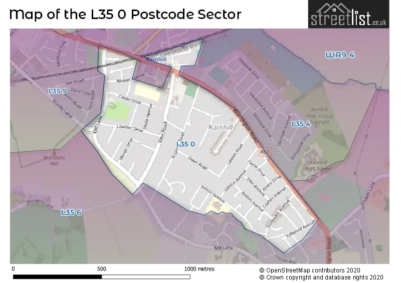
The L35 0 Postcode shares a border with L35 4 (Rainhill), L35 6 (Rainhill) and L35 9 (Rainhill).
Map of the L35 0 Postcode Sector
Explore the L35 0 postcode sector by using our interactive map.
The sector is within the post town of PRESCOT.
L35 0 is a postcode sector within the L35 postcode district which is within the L Liverpool postcode area.
The Royal Mail delivery office for the L35 0 postal sector is the Prescot Delivery Office.
The area of the L35 0 postcode sector is 0.29 square miles which is 0.75 square kilometres or 185.07 square acres.
Your support helps keep this site running!
If you enjoy using this website, consider buying me a coffee to help cover hosting costs.


| L | 3 | 5 | - | 0 | X | X |
| L | 3 | 5 | Space | 0 | Letter | Letter |
Official List of Streets
Rainhill (51 Streets)
PRESCOT (1 Streets)
Unofficial Streets or Alternative Spellings
Weather Forecast for L35 0
Weather Forecast for Whiston Cross
| Time Period | Icon | Description | Temperature | Rain Probability | Wind |
|---|---|---|---|---|---|
| 03:00 to 06:00 | Cloudy | 8.0°C (feels like 5.0°C) | 6.00% | SSE 13 mph | |
| 06:00 to 09:00 | Overcast | 8.0°C (feels like 5.0°C) | 9.00% | S 13 mph | |
| 09:00 to 12:00 | Cloudy | 9.0°C (feels like 5.0°C) | 8.00% | S 16 mph | |
| 12:00 to 15:00 | Cloudy | 9.0°C (feels like 6.0°C) | 19.00% | S 16 mph | |
| 15:00 to 18:00 | Light rain | 9.0°C (feels like 7.0°C) | 57.00% | WSW 11 mph | |
| 18:00 to 21:00 | Clear night | 8.0°C (feels like 5.0°C) | 7.00% | SW 11 mph | |
| 21:00 to 00:00 | Clear night | 6.0°C (feels like 3.0°C) | 2.00% | WSW 11 mph |
| Time Period | Icon | Description | Temperature | Rain Probability | Wind |
|---|---|---|---|---|---|
| 00:00 to 03:00 | Clear night | 5.0°C (feels like 2.0°C) | 1.00% | WSW 11 mph | |
| 03:00 to 06:00 | Clear night | 5.0°C (feels like 1.0°C) | 0.00% | WSW 11 mph | |
| 06:00 to 09:00 | Clear night | 5.0°C (feels like 2.0°C) | 31.00% | W 9 mph | |
| 09:00 to 12:00 | Cloudy | 5.0°C (feels like 2.0°C) | 4.00% | W 9 mph | |
| 12:00 to 15:00 | Cloudy | 7.0°C (feels like 4.0°C) | 5.00% | W 9 mph | |
| 15:00 to 18:00 | Sunny day | 7.0°C (feels like 5.0°C) | 0.00% | WNW 9 mph | |
| 18:00 to 21:00 | Clear night | 4.0°C (feels like 2.0°C) | 1.00% | WNW 4 mph | |
| 21:00 to 00:00 | Clear night | 3.0°C (feels like 1.0°C) | 1.00% | WSW 2 mph |
| Time Period | Icon | Description | Temperature | Rain Probability | Wind |
|---|---|---|---|---|---|
| 00:00 to 03:00 | Clear night | 1.0°C (feels like 0.0°C) | 1.00% | SSE 2 mph | |
| 03:00 to 06:00 | Clear night | 0.0°C (feels like -2.0°C) | 2.00% | SE 4 mph | |
| 06:00 to 09:00 | Clear night | -1.0°C (feels like -3.0°C) | 4.00% | ESE 4 mph | |
| 09:00 to 12:00 | Sunny day | 0.0°C (feels like -2.0°C) | 4.00% | ESE 4 mph | |
| 12:00 to 15:00 | Sunny day | 4.0°C (feels like 3.0°C) | 0.00% | SE 4 mph | |
| 15:00 to 18:00 | Sunny day | 7.0°C (feels like 5.0°C) | 0.00% | ESE 7 mph | |
| 18:00 to 21:00 | Clear night | 4.0°C (feels like 2.0°C) | 0.00% | ESE 7 mph | |
| 21:00 to 00:00 | Clear night | 2.0°C (feels like 0.0°C) | 0.00% | ESE 7 mph |
| Time Period | Icon | Description | Temperature | Rain Probability | Wind |
|---|---|---|---|---|---|
| 00:00 to 03:00 | Clear night | 1.0°C (feels like -2.0°C) | 1.00% | ESE 7 mph | |
| 03:00 to 06:00 | Clear night | 1.0°C (feels like -2.0°C) | 1.00% | ESE 7 mph | |
| 06:00 to 09:00 | Clear night | 0.0°C (feels like -3.0°C) | 2.00% | ESE 4 mph | |
| 09:00 to 12:00 | Sunny day | 1.0°C (feels like -2.0°C) | 3.00% | ESE 4 mph | |
| 12:00 to 15:00 | Sunny day | 4.0°C (feels like 2.0°C) | 1.00% | ESE 7 mph | |
| 15:00 to 18:00 | Sunny day | 6.0°C (feels like 3.0°C) | 1.00% | E 7 mph | |
| 18:00 to 21:00 | Clear night | 3.0°C (feels like 1.0°C) | 1.00% | E 7 mph | |
| 21:00 to 00:00 | Clear night | 2.0°C (feels like -1.0°C) | 1.00% | E 7 mph |
Schools and Places of Education Within the L35 0 Postcode Sector
Oakdene Primary School
Community school
Ashton Avenue, Prescot, Merseyside, L35 0QQ
Head: Ms Lynsey Young
Ofsted Rating: Outstanding
Inspection: 2012-11-02 (4477 days ago)
Website: Visit Oakdene Primary School Website
Phone: 01744678410
Number of Pupils: 210
House Prices in the L35 0 Postcode Sector
| Type of Property | 2018 Average | 2018 Sales | 2017 Average | 2017 Sales | 2016 Average | 2016 Sales | 2015 Average | 2015 Sales |
|---|---|---|---|---|---|---|---|---|
| Detached | £309,612 | 13 | £300,533 | 15 | £399,188 | 16 | £292,559 | 17 |
| Semi-Detached | £194,193 | 15 | £175,030 | 15 | £207,603 | 19 | £184,438 | 8 |
| Terraced | £162,556 | 9 | £146,250 | 2 | £160,750 | 4 | £139,500 | 6 |
| Flats | £115,000 | 1 | £101,000 | 3 | £113,000 | 5 | £95,300 | 5 |
Important Postcodes L35 0 in the Postcode Sector
L35 0LE is the postcode for St. Helens Metropolitan Borough Council, Rainhill Library, View Road
L35 0LQ is the postcode for St. Anns C of E Primary School, View Road
L35 0QQ is the postcode for Oakdene Primary School, Ashton Avenue, and Oakdene Primary School, Ashton Avenue, Rainhill
| The L35 0 Sector is within these Local Authorities |
|
|---|---|
| The L35 0 Sector is within these Counties |
|
| The L35 0 Sector is within these Water Company Areas |
|