A wide range of spatial data has been analysed to present this overview of the L32 0 Postcode sector. If you would like anything added, please contact us.
The L32 0 postcode sector is within the county of Merseyside.
Did you know? According to the 2021 Census, the L32 0 postcode sector is home to a bustling 3,723 residents!
Given that each sector allows for 400 unique postcode combinations. Letters C, I, K, M, O and V are not allowed in the last two letters of a postcode. With 87 postcodes already in use, this leaves 313 units available.
The largest settlements in the L32 0 postal code are LIVERPOOL and Kirkby.
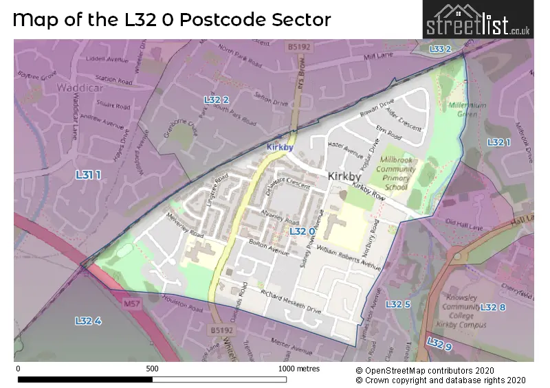
The L32 0 Postcode shares a border with L31 1 (Melling, Maghull, LIVERPOOL), L32 1 (Kirkby, LIVERPOOL), L32 4 (LIVERPOOL, Kirkby), L32 5 (LIVERPOOL, Kirkby) and L32 2 (LIVERPOOL, Kirkby).
Map of the L32 0 Postcode Sector
Explore the L32 0 postcode sector by using our interactive map.
The sector is within the post town of LIVERPOOL.
L32 0 is a postcode sector within the L32 postcode district which is within the L Liverpool postcode area.
The Royal Mail delivery office for the L32 0 postal sector is the Kirkby Delivery Office.
The area of the L32 0 postcode sector is 0.29 square miles which is 0.75 square kilometres or 185.27 square acres.
The L32 0 postcode sector is crossed by the M57 motorway.
Your support helps keep this site running!
If you enjoy using this website, consider buying me a coffee to help cover hosting costs.


| L | 3 | 2 | - | 0 | X | X |
| L | 3 | 2 | Space | 0 | Letter | Letter |
Official List of Streets
LIVERPOOL (46 Streets)
Kirkby (9 Streets)
(1 Streets)
Unofficial Streets or Alternative Spellings
Weather Forecast for L32 0
Weather Forecast for Kirkby
| Time Period | Icon | Description | Temperature | Rain Probability | Wind |
|---|---|---|---|---|---|
| 06:00 to 09:00 | Cloudy | 5.0°C (feels like 0.0°C) | 5.00% | SSE 13 mph | |
| 09:00 to 12:00 | Cloudy | 5.0°C (feels like 1.0°C) | 9.00% | SSE 13 mph | |
| 12:00 to 15:00 | Overcast | 6.0°C (feels like 2.0°C) | 11.00% | SSE 11 mph | |
| 15:00 to 18:00 | Overcast | 7.0°C (feels like 4.0°C) | 15.00% | SSE 7 mph | |
| 18:00 to 21:00 | Overcast | 7.0°C (feels like 5.0°C) | 13.00% | SSE 7 mph | |
| 21:00 to 00:00 | Cloudy | 6.0°C (feels like 4.0°C) | 5.00% | S 7 mph |
| Time Period | Icon | Description | Temperature | Rain Probability | Wind |
|---|---|---|---|---|---|
| 00:00 to 03:00 | Cloudy | 6.0°C (feels like 3.0°C) | 5.00% | S 7 mph | |
| 03:00 to 06:00 | Cloudy | 5.0°C (feels like 2.0°C) | 4.00% | SSE 7 mph | |
| 06:00 to 09:00 | Cloudy | 4.0°C (feels like 1.0°C) | 4.00% | SSE 9 mph | |
| 09:00 to 12:00 | Cloudy | 4.0°C (feels like 0.0°C) | 4.00% | SSE 11 mph | |
| 12:00 to 15:00 | Cloudy | 7.0°C (feels like 4.0°C) | 4.00% | SSE 11 mph | |
| 15:00 to 18:00 | Cloudy | 9.0°C (feels like 6.0°C) | 4.00% | S 11 mph | |
| 18:00 to 21:00 | Cloudy | 8.0°C (feels like 5.0°C) | 4.00% | S 11 mph | |
| 21:00 to 00:00 | Cloudy | 7.0°C (feels like 3.0°C) | 4.00% | SSE 13 mph |
| Time Period | Icon | Description | Temperature | Rain Probability | Wind |
|---|---|---|---|---|---|
| 00:00 to 03:00 | Cloudy | 7.0°C (feels like 4.0°C) | 5.00% | S 13 mph | |
| 03:00 to 06:00 | Cloudy | 8.0°C (feels like 4.0°C) | 5.00% | S 13 mph | |
| 06:00 to 09:00 | Cloudy | 8.0°C (feels like 5.0°C) | 10.00% | S 16 mph | |
| 09:00 to 12:00 | Cloudy | 8.0°C (feels like 5.0°C) | 16.00% | S 16 mph | |
| 12:00 to 15:00 | Cloudy | 9.0°C (feels like 6.0°C) | 22.00% | SSW 16 mph | |
| 15:00 to 18:00 | Cloudy | 9.0°C (feels like 6.0°C) | 20.00% | SW 13 mph | |
| 18:00 to 21:00 | Clear night | 8.0°C (feels like 5.0°C) | 11.00% | SW 13 mph | |
| 21:00 to 00:00 | Clear night | 7.0°C (feels like 4.0°C) | 6.00% | WSW 13 mph |
| Time Period | Icon | Description | Temperature | Rain Probability | Wind |
|---|---|---|---|---|---|
| 00:00 to 03:00 | Clear night | 7.0°C (feels like 3.0°C) | 2.00% | W 16 mph | |
| 03:00 to 06:00 | Clear night | 6.0°C (feels like 3.0°C) | 2.00% | W 13 mph | |
| 06:00 to 09:00 | Clear night | 6.0°C (feels like 2.0°C) | 3.00% | W 11 mph | |
| 09:00 to 12:00 | Partly cloudy (day) | 6.0°C (feels like 3.0°C) | 2.00% | WSW 9 mph | |
| 12:00 to 15:00 | Cloudy | 7.0°C (feels like 5.0°C) | 4.00% | WSW 9 mph | |
| 15:00 to 18:00 | Sunny day | 7.0°C (feels like 6.0°C) | 1.00% | WSW 7 mph | |
| 18:00 to 21:00 | Clear night | 6.0°C (feels like 4.0°C) | 1.00% | SSW 4 mph | |
| 21:00 to 00:00 | Clear night | 5.0°C (feels like 2.0°C) | 1.00% | S 7 mph |
Schools and Places of Education Within the L32 0 Postcode Sector
Millbrook Community Primary School
Community school
Kirkby Row, Liverpool, Merseyside, L32 0TG
Head: Mrs Jane Maloney
Ofsted Rating: Good
Inspection: 2019-12-18 (1873 days ago)
Website: Visit Millbrook Community Primary School Website
Phone: 01514778160
Number of Pupils: 316
St Michael and All Angels Catholic Primary School
Voluntary aided school
Sidney Powell Avenue, Liverpool, Merseyside, L32 0TP
Head: Miss A L Bowman
Ofsted Rating: Requires improvement
Inspection: 2023-10-05 (486 days ago)
Website: Visit St Michael and All Angels Catholic Primary School Website
Phone: 01514778400
Number of Pupils: 439
Westvale Primary School
Community school
Melverley Road, Liverpool, Merseyside, L32 0RQ
Head: Mr Colin Richardson
Ofsted Rating: Requires improvement
Inspection: 2023-05-18 (626 days ago)
Website: Visit Westvale Primary School Website
Phone: 01514778470
Number of Pupils: 229
House Prices in the L32 0 Postcode Sector
| Type of Property | 2018 Average | 2018 Sales | 2017 Average | 2017 Sales | 2016 Average | 2016 Sales | 2015 Average | 2015 Sales |
|---|---|---|---|---|---|---|---|---|
| Detached | £0 | 0 | £0 | 0 | £0 | 0 | £0 | 0 |
| Semi-Detached | £116,528 | 9 | £105,928 | 18 | £107,425 | 16 | £114,464 | 11 |
| Terraced | £85,969 | 26 | £80,200 | 20 | £87,525 | 16 | £76,800 | 10 |
| Flats | £0 | 0 | £0 | 0 | £30,000 | 1 | £0 | 0 |
Important Postcodes L32 0 in the Postcode Sector
L32 0RQ is the postcode for Westvale Primary School, Melverley Road
L32 0TG is the postcode for Millbrook Primary School, Kirkby Row
L32 0TP is the postcode for St. Michael and All Angels Catholic Primary School, Sidney Powell Avenue
L32 0TZ is the postcode for Westvale Health Centre, Richard Hesketh Drive
| The L32 0 Sector is within these Local Authorities |
|
|---|---|
| The L32 0 Sector is within these Counties |
|
| The L32 0 Sector is within these Water Company Areas |
|