A wide range of spatial data has been analysed to present this overview of the L26 6 Postcode sector. If you would like anything added, please contact us.
The L26 6 postcode sector is within the county of Merseyside.
Did you know? According to the 2021 Census, the L26 6 postcode sector is home to a bustling 1,826 residents!
Given that each sector allows for 400 unique postcode combinations. Letters C, I, K, M, O and V are not allowed in the last two letters of a postcode. With 35 postcodes already in use, this leaves 365 units available.
The largest settlements in the L26 6 postal code are Halewood and LIVERPOOL.
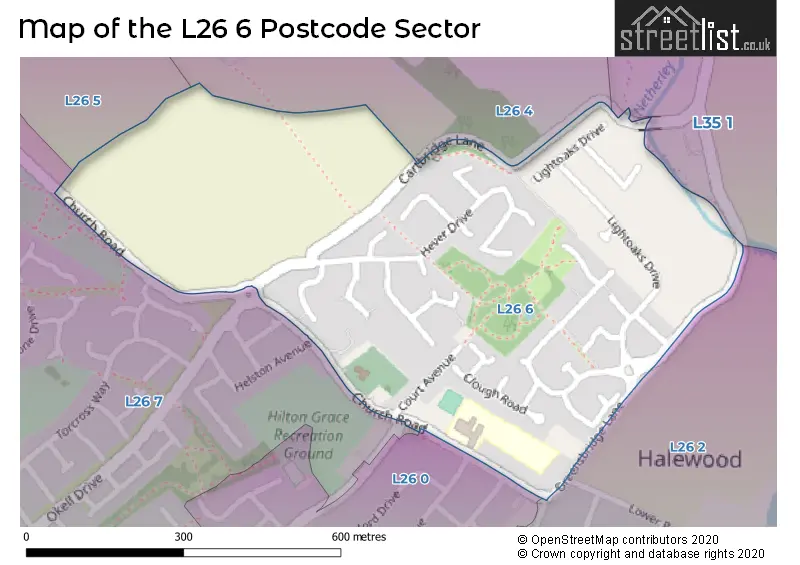
The L26 6 Postcode shares a border with L26 0 (LIVERPOOL, Halewood), L26 2 (Halewood, LIVERPOOL), L26 4 (LIVERPOOL), L26 5 (Halewood, LIVERPOOL), L26 7 (LIVERPOOL, Halewood) and L35 1 (Tarbock Green, Whiston, Tarbock).
Map of the L26 6 Postcode Sector
Explore the L26 6 postcode sector by using our interactive map.
The sector is within the post town of LIVERPOOL.
L26 6 is a postcode sector within the L26 postcode district which is within the L Liverpool postcode area.
The Royal Mail delivery office for the L26 6 postal sector is the Woolton Delivery Office.
The area of the L26 6 postcode sector is 0.22 square miles which is 0.56 square kilometres or 138.13 square acres.
Waterways within the L26 6 postcode sector include the Netherley Brook.
Your support helps keep this site running!
If you enjoy using this website, consider buying me a coffee to help cover hosting costs.


| L | 2 | 6 | - | 6 | X | X |
| L | 2 | 6 | Space | 6 | Letter | Letter |
Official List of Streets
Halewood (22 Streets)
LIVERPOOL (14 Streets)
(1 Streets)
Unofficial Streets or Alternative Spellings
LIVERPOOL,
LOWER ROADTarbock Green
GREENSBRIDGE LANELIVERPOOL
ELWYN DRIVE HELSTON AVENUE HOLLIES ROAD HAYFLELD CLOSE STROKES CLOSEWeather Forecast for L26 6
Weather Forecast for Halewood
| Time Period | Icon | Description | Temperature | Rain Probability | Wind |
|---|---|---|---|---|---|
| 00:00 to 03:00 | Overcast | 2.0°C (feels like -1.0°C) | 11.00% | SE 9 mph | |
| 03:00 to 06:00 | Cloudy | 2.0°C (feels like -2.0°C) | 8.00% | SE 9 mph | |
| 06:00 to 09:00 | Overcast | 2.0°C (feels like -2.0°C) | 11.00% | SE 9 mph | |
| 09:00 to 12:00 | Overcast | 2.0°C (feels like -2.0°C) | 11.00% | SE 7 mph | |
| 12:00 to 15:00 | Overcast | 3.0°C (feels like 0.0°C) | 9.00% | SE 7 mph | |
| 15:00 to 18:00 | Overcast | 4.0°C (feels like 1.0°C) | 9.00% | ESE 7 mph | |
| 18:00 to 21:00 | Overcast | 3.0°C (feels like 1.0°C) | 10.00% | SSE 4 mph | |
| 21:00 to 00:00 | Overcast | 2.0°C (feels like 0.0°C) | 12.00% | SE 4 mph |
| Time Period | Icon | Description | Temperature | Rain Probability | Wind |
|---|---|---|---|---|---|
| 00:00 to 03:00 | Mist | 2.0°C (feels like 0.0°C) | 21.00% | SE 4 mph | |
| 03:00 to 06:00 | Mist | 2.0°C (feels like 0.0°C) | 22.00% | S 7 mph | |
| 06:00 to 09:00 | Overcast | 3.0°C (feels like 0.0°C) | 15.00% | SSW 7 mph | |
| 09:00 to 12:00 | Overcast | 3.0°C (feels like 0.0°C) | 15.00% | SSW 7 mph | |
| 12:00 to 15:00 | Overcast | 5.0°C (feels like 2.0°C) | 15.00% | SSE 9 mph | |
| 15:00 to 18:00 | Overcast | 6.0°C (feels like 3.0°C) | 15.00% | SSW 9 mph | |
| 18:00 to 21:00 | Cloudy | 5.0°C (feels like 2.0°C) | 10.00% | SSW 9 mph | |
| 21:00 to 00:00 | Cloudy | 5.0°C (feels like 2.0°C) | 11.00% | SSW 9 mph |
Schools and Places of Education Within the L26 6 Postcode Sector
Halewood Church of England Primary Academy
Academy converter
Church Road, Liverpool, Merseyside, L26 6LB
Head: Mr Dave Catt
Ofsted Rating: Good
Inspection: 2023-04-26 (637 days ago)
Website: Visit Halewood Church of England Primary Academy Website
Phone: 01514875673
Number of Pupils: 235
House Prices in the L26 6 Postcode Sector
| Type of Property | 2018 Average | 2018 Sales | 2017 Average | 2017 Sales | 2016 Average | 2016 Sales | 2015 Average | 2015 Sales |
|---|---|---|---|---|---|---|---|---|
| Detached | £274,766 | 34 | £274,813 | 55 | £243,288 | 12 | £250,231 | 13 |
| Semi-Detached | £190,277 | 44 | £195,044 | 19 | £199,250 | 4 | £0 | 0 |
| Terraced | £205,000 | 2 | £189,000 | 2 | £0 | 0 | £188,475 | 2 |
| Flats | £89,488 | 4 | £93,000 | 1 | £64,500 | 1 | £88,317 | 3 |
Important Postcodes L26 6 in the Postcode Sector
L26 6LB is the postcode for Halewood C of E Primary School, Church Road, and Halewood C of E Primary School, Church Road, Halewood
| The L26 6 Sector is within these Local Authorities |
|
|---|---|
| The L26 6 Sector is within these Counties |
|
| The L26 6 Sector is within these Water Company Areas |
|