A wide range of spatial data has been analysed to present this overview of the L26 1 Postcode sector. If you would like anything added, please contact us.
The L26 1 postcode sector is within the county of Merseyside.
Did you know? According to the 2021 Census, the L26 1 postcode sector is home to a bustling 3,153 residents!
Given that each sector allows for 400 unique postcode combinations. Letters C, I, K, M, O and V are not allowed in the last two letters of a postcode. With 62 postcodes already in use, this leaves 338 units available.
The largest settlements in the L26 1 postal code are LIVERPOOL and Halewood.
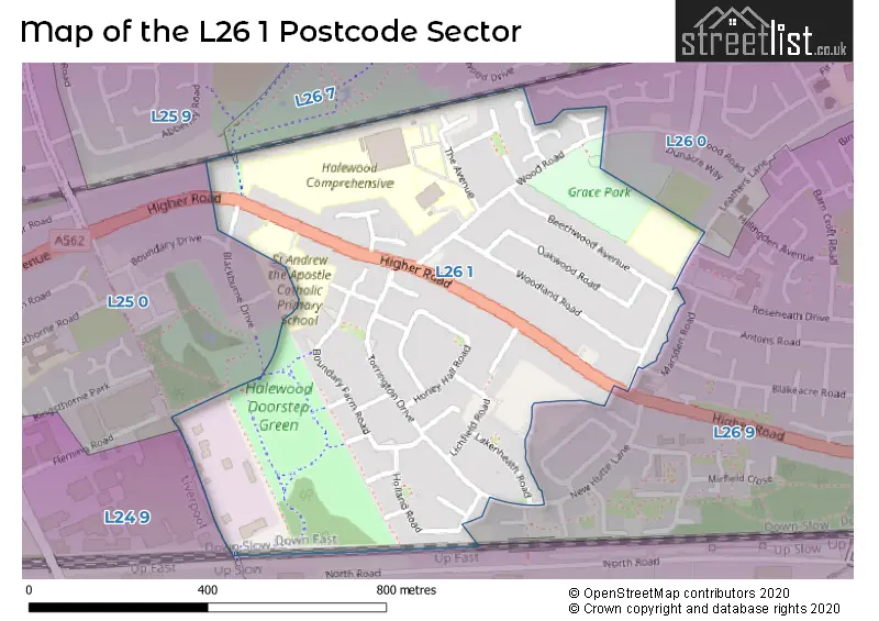
The L26 1 Postcode shares a border with L26 0 (LIVERPOOL, Halewood), L24 9 (LIVERPOOL, Speke, Halewood), L25 0 (LIVERPOOL, Hunts Cross, Woolton), L26 9 (LIVERPOOL, Halewood), L25 9 (LIVERPOOL, Hunts Cross, Woolton) and L26 7 (LIVERPOOL, Halewood).
Map of the L26 1 Postcode Sector
Explore the L26 1 postcode sector by using our interactive map.
The sector is within the post town of LIVERPOOL.
L26 1 is a postcode sector within the L26 postcode district which is within the L Liverpool postcode area.
The Royal Mail delivery office for the L26 1 postal sector is the Woolton Delivery Office.
The area of the L26 1 postcode sector is 0.31 square miles which is 0.81 square kilometres or 199.17 square acres.
Your support helps keep this site running!
If you enjoy using this website, consider buying me a coffee to help cover hosting costs.

| L | 2 | 6 | - | 1 | X | X |
| L | 2 | 6 | Space | 1 | Letter | Letter |
Official List of Streets
LIVERPOOL (28 Streets)
(2 Streets)
Unofficial Streets or Alternative Spellings
LIVERPOOL
BLACKBURNE DRIVE MARSDEN ROAD NEW HUTTE LANE ROSEHEATH DRIVELIVERPOOL,
HIGHER ROAD BLACKBURNE DRIVE COTSWOLD CRESCENTWeather Forecast for L26 1
Weather Forecast for Hunt's Cross
| Time Period | Icon | Description | Temperature | Rain Probability | Wind |
|---|---|---|---|---|---|
| 18:00 to 21:00 | Cloudy | 5.0°C (feels like 2.0°C) | 3.00% | SSE 11 mph | |
| 21:00 to 00:00 | Cloudy | 5.0°C (feels like 1.0°C) | 5.00% | SSE 11 mph |
| Time Period | Icon | Description | Temperature | Rain Probability | Wind |
|---|---|---|---|---|---|
| 00:00 to 03:00 | Cloudy | 6.0°C (feels like 2.0°C) | 8.00% | SSE 13 mph | |
| 03:00 to 06:00 | Overcast | 5.0°C (feels like 1.0°C) | 8.00% | SSE 13 mph | |
| 06:00 to 09:00 | Cloudy | 5.0°C (feels like 0.0°C) | 5.00% | SSE 13 mph | |
| 09:00 to 12:00 | Cloudy | 5.0°C (feels like 1.0°C) | 7.00% | SSE 11 mph | |
| 12:00 to 15:00 | Overcast | 6.0°C (feels like 3.0°C) | 10.00% | SSE 11 mph | |
| 15:00 to 18:00 | Overcast | 7.0°C (feels like 5.0°C) | 14.00% | S 7 mph | |
| 18:00 to 21:00 | Overcast | 7.0°C (feels like 4.0°C) | 10.00% | S 7 mph | |
| 21:00 to 00:00 | Cloudy | 6.0°C (feels like 4.0°C) | 5.00% | S 7 mph |
| Time Period | Icon | Description | Temperature | Rain Probability | Wind |
|---|---|---|---|---|---|
| 00:00 to 03:00 | Cloudy | 6.0°C (feels like 3.0°C) | 4.00% | S 7 mph | |
| 03:00 to 06:00 | Cloudy | 5.0°C (feels like 2.0°C) | 4.00% | S 9 mph | |
| 06:00 to 09:00 | Cloudy | 4.0°C (feels like 1.0°C) | 4.00% | S 9 mph | |
| 09:00 to 12:00 | Cloudy | 5.0°C (feels like 1.0°C) | 4.00% | SSE 11 mph | |
| 12:00 to 15:00 | Cloudy | 8.0°C (feels like 5.0°C) | 4.00% | S 11 mph | |
| 15:00 to 18:00 | Cloudy | 10.0°C (feels like 7.0°C) | 4.00% | S 13 mph | |
| 18:00 to 21:00 | Cloudy | 8.0°C (feels like 4.0°C) | 5.00% | S 13 mph | |
| 21:00 to 00:00 | Cloudy | 7.0°C (feels like 3.0°C) | 4.00% | S 13 mph |
| Time Period | Icon | Description | Temperature | Rain Probability | Wind |
|---|---|---|---|---|---|
| 00:00 to 03:00 | Cloudy | 8.0°C (feels like 4.0°C) | 5.00% | S 16 mph | |
| 03:00 to 06:00 | Cloudy | 8.0°C (feels like 4.0°C) | 5.00% | S 16 mph | |
| 06:00 to 09:00 | Cloudy | 8.0°C (feels like 4.0°C) | 7.00% | S 16 mph | |
| 09:00 to 12:00 | Cloudy | 9.0°C (feels like 5.0°C) | 12.00% | S 16 mph | |
| 12:00 to 15:00 | Cloudy | 10.0°C (feels like 7.0°C) | 18.00% | SSW 16 mph | |
| 15:00 to 18:00 | Cloudy | 10.0°C (feels like 7.0°C) | 17.00% | SW 13 mph | |
| 18:00 to 21:00 | Clear night | 8.0°C (feels like 5.0°C) | 10.00% | SW 11 mph | |
| 21:00 to 00:00 | Clear night | 7.0°C (feels like 4.0°C) | 4.00% | WSW 13 mph |
| Time Period | Icon | Description | Temperature | Rain Probability | Wind |
|---|---|---|---|---|---|
| 00:00 to 03:00 | Clear night | 6.0°C (feels like 3.0°C) | 2.00% | W 13 mph | |
| 03:00 to 06:00 | Clear night | 5.0°C (feels like 2.0°C) | 2.00% | W 11 mph | |
| 06:00 to 09:00 | Clear night | 5.0°C (feels like 1.0°C) | 1.00% | W 11 mph | |
| 09:00 to 12:00 | Partly cloudy (day) | 5.0°C (feels like 2.0°C) | 1.00% | W 9 mph | |
| 12:00 to 15:00 | Cloudy | 7.0°C (feels like 5.0°C) | 4.00% | W 9 mph | |
| 15:00 to 18:00 | Partly cloudy (day) | 8.0°C (feels like 6.0°C) | 1.00% | W 7 mph | |
| 18:00 to 21:00 | Clear night | 6.0°C (feels like 4.0°C) | 1.00% | WSW 4 mph | |
| 21:00 to 00:00 | Clear night | 4.0°C (feels like 2.0°C) | 1.00% | SSW 7 mph |
Schools and Places of Education Within the L26 1 Postcode Sector
Halewood Academy
Academy converter
The Avenue, Knowsley, Merseyside, L26 1UU
Head: Mr Ian Critchely
Ofsted Rating: Good
Inspection: 2022-03-17 (1052 days ago)
Website: Visit Halewood Academy Website
Phone: 01514778830
Number of Pupils: 1104
St Andrew the Apostle Catholic Primary School
Voluntary aided school
Higher Road, Liverpool, Merseyside, L26 1TD
Head: Mrs J Webster
Ofsted Rating: Good
Inspection: 2020-02-26 (1802 days ago)
Website: Visit St Andrew the Apostle Catholic Primary School Website
Phone: 01512888940
Number of Pupils: 241
Yew Tree Primary Academy
Academy converter
The Avenue, Knowsley, Merseyside, L26 1UU
Head: Mrs Rebecca O'Hanlon
Ofsted Rating: Good
Inspection: 2023-01-18 (745 days ago)
Website: Visit Yew Tree Primary Academy Website
Phone: 01514778950
Number of Pupils: 248
House Prices in the L26 1 Postcode Sector
| Type of Property | 2018 Average | 2018 Sales | 2017 Average | 2017 Sales | 2016 Average | 2016 Sales | 2015 Average | 2015 Sales |
|---|---|---|---|---|---|---|---|---|
| Detached | £167,500 | 2 | £199,392 | 2 | £193,000 | 2 | £180,000 | 1 |
| Semi-Detached | £139,792 | 24 | £147,681 | 13 | £138,200 | 20 | £133,879 | 17 |
| Terraced | £96,000 | 9 | £88,071 | 21 | £88,455 | 11 | £85,656 | 8 |
| Flats | £45,000 | 1 | £0 | 0 | £62,500 | 1 | £0 | 0 |
Important Postcodes L26 1 in the Postcode Sector
L26 1TD is the postcode for St. Andrews RC Primary & Nursery School, Higher Road
L26 1UU is the postcode for Yew Tree Cp School, The Avenue, Yew Tree Cp School, The Avenue, Halewood, HALEWOOD ACADEMY, THE AVENUE, HALEWOOD ACADEMY, THE AVENUE, HALEWOOD, Halewood Academy, Wood Road, and Halewood College, The Avenue
L26 1XQ is the postcode for Greengates Community Primary School, Leathers Lane
| The L26 1 Sector is within these Local Authorities |
|
|---|---|
| The L26 1 Sector is within these Counties |
|
| The L26 1 Sector is within these Water Company Areas |
|