A wide range of spatial data has been analysed to present this overview of the L26 0 Postcode sector. If you would like anything added, please contact us.
The L26 0 postcode sector is within the county of Merseyside.
Did you know? According to the 2021 Census, the L26 0 postcode sector is home to a bustling 2,396 residents!
Given that each sector allows for 400 unique postcode combinations. Letters C, I, K, M, O and V are not allowed in the last two letters of a postcode. With 51 postcodes already in use, this leaves 349 units available.
The largest settlements in the L26 0 postal code are LIVERPOOL and Halewood.
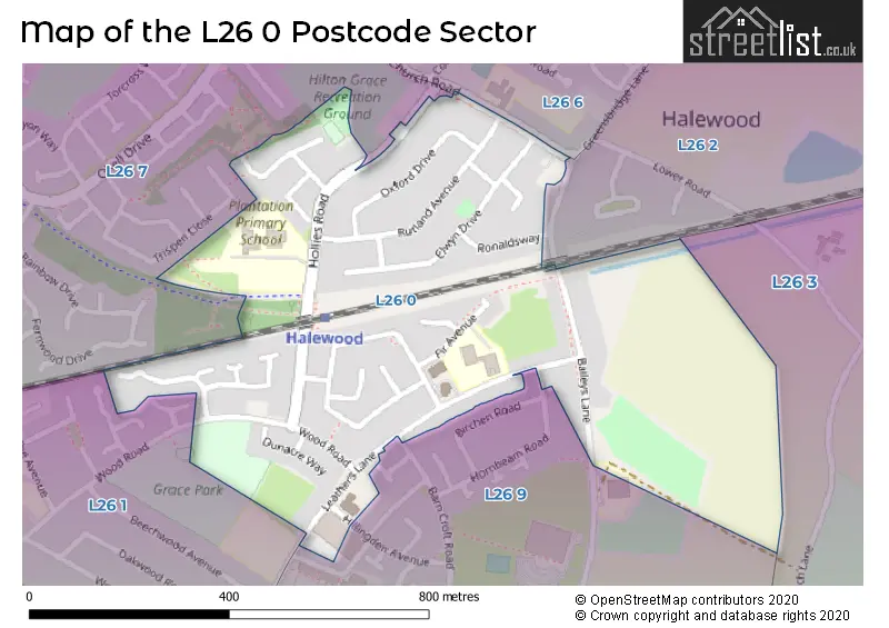
The L26 0 Postcode shares a border with L26 2 (Halewood, LIVERPOOL), L26 3 (LIVERPOOL, Halewood), L26 6 (Halewood, LIVERPOOL), L26 9 (LIVERPOOL, Halewood), L26 1 (LIVERPOOL, Halewood) and L26 7 (LIVERPOOL, Halewood).
Map of the L26 0 Postcode Sector
Explore the L26 0 postcode sector by using our interactive map.
The sector is within the post town of LIVERPOOL.
L26 0 is a postcode sector within the L26 postcode district which is within the L Liverpool postcode area.
The Royal Mail delivery office for the L26 0 postal sector is the Woolton Delivery Office.
The area of the L26 0 postcode sector is 0.26 square miles which is 0.67 square kilometres or 166.79 square acres.
Your support helps keep this site running!
If you enjoy using this website, consider buying me a coffee to help cover hosting costs.


| L | 2 | 6 | - | 0 | X | X |
| L | 2 | 6 | Space | 0 | Letter | Letter |
Official List of Streets
(10 Streets)
Halewood (16 Streets)
LIVERPOOL (18 Streets)
Unofficial Streets or Alternative Spellings
Weather Forecast for L26 0
Weather Forecast for Halewood
| Time Period | Icon | Description | Temperature | Rain Probability | Wind |
|---|---|---|---|---|---|
| 21:00 to 00:00 | Cloudy | 4.0°C (feels like 1.0°C) | 3.00% | NNW 11 mph |
| Time Period | Icon | Description | Temperature | Rain Probability | Wind |
|---|---|---|---|---|---|
| 00:00 to 03:00 | Clear night | 4.0°C (feels like 0.0°C) | 1.00% | NNW 9 mph | |
| 03:00 to 06:00 | Clear night | 3.0°C (feels like 0.0°C) | 1.00% | NW 9 mph | |
| 06:00 to 09:00 | Clear night | 4.0°C (feels like 0.0°C) | 3.00% | NW 9 mph | |
| 09:00 to 12:00 | Sunny day | 4.0°C (feels like 1.0°C) | 1.00% | WNW 9 mph | |
| 12:00 to 15:00 | Sunny day | 6.0°C (feels like 3.0°C) | 2.00% | WNW 11 mph | |
| 15:00 to 18:00 | Partly cloudy (day) | 6.0°C (feels like 3.0°C) | 7.00% | WNW 9 mph | |
| 18:00 to 21:00 | Clear night | 4.0°C (feels like 2.0°C) | 1.00% | WSW 7 mph | |
| 21:00 to 00:00 | Cloudy | 3.0°C (feels like 1.0°C) | 4.00% | SSW 7 mph |
| Time Period | Icon | Description | Temperature | Rain Probability | Wind |
|---|---|---|---|---|---|
| 00:00 to 03:00 | Cloudy | 4.0°C (feels like 1.0°C) | 56.00% | S 9 mph | |
| 03:00 to 06:00 | Heavy rain | 4.0°C (feels like 0.0°C) | 84.00% | S 11 mph | |
| 06:00 to 09:00 | Light rain | 5.0°C (feels like 2.0°C) | 56.00% | WSW 13 mph | |
| 09:00 to 12:00 | Partly cloudy (day) | 6.0°C (feels like 3.0°C) | 9.00% | NW 11 mph | |
| 12:00 to 15:00 | Cloudy | 7.0°C (feels like 5.0°C) | 6.00% | NNW 11 mph | |
| 15:00 to 18:00 | Cloudy | 7.0°C (feels like 5.0°C) | 5.00% | W 9 mph | |
| 18:00 to 21:00 | Cloudy | 5.0°C (feels like 3.0°C) | 5.00% | SW 4 mph | |
| 21:00 to 00:00 | Overcast | 4.0°C (feels like 2.0°C) | 8.00% | SSW 7 mph |
| Time Period | Icon | Description | Temperature | Rain Probability | Wind |
|---|---|---|---|---|---|
| 00:00 to 03:00 | Overcast | 3.0°C (feels like 1.0°C) | 9.00% | SE 7 mph | |
| 03:00 to 06:00 | Overcast | 3.0°C (feels like 0.0°C) | 10.00% | SSE 9 mph | |
| 06:00 to 09:00 | Overcast | 3.0°C (feels like 0.0°C) | 9.00% | SSE 11 mph | |
| 09:00 to 12:00 | Overcast | 4.0°C (feels like 0.0°C) | 9.00% | SSE 11 mph | |
| 12:00 to 15:00 | Overcast | 6.0°C (feels like 2.0°C) | 9.00% | SSE 13 mph | |
| 15:00 to 18:00 | Cloudy | 7.0°C (feels like 3.0°C) | 6.00% | SSE 16 mph | |
| 18:00 to 21:00 | Cloudy | 6.0°C (feels like 3.0°C) | 6.00% | SSE 16 mph | |
| 21:00 to 00:00 | Cloudy | 6.0°C (feels like 2.0°C) | 8.00% | SSE 16 mph |
| Time Period | Icon | Description | Temperature | Rain Probability | Wind |
|---|---|---|---|---|---|
| 00:00 to 03:00 | Cloudy | 5.0°C (feels like 1.0°C) | 11.00% | SSE 18 mph | |
| 03:00 to 06:00 | Overcast | 5.0°C (feels like 1.0°C) | 18.00% | S 16 mph | |
| 06:00 to 09:00 | Overcast | 5.0°C (feels like 1.0°C) | 22.00% | S 13 mph | |
| 09:00 to 12:00 | Cloudy | 5.0°C (feels like 1.0°C) | 20.00% | SSW 13 mph | |
| 12:00 to 15:00 | Cloudy | 6.0°C (feels like 3.0°C) | 16.00% | SW 11 mph | |
| 15:00 to 18:00 | Overcast | 7.0°C (feels like 4.0°C) | 13.00% | SW 11 mph | |
| 18:00 to 21:00 | Cloudy | 6.0°C (feels like 3.0°C) | 8.00% | SW 9 mph | |
| 21:00 to 00:00 | Partly cloudy (night) | 5.0°C (feels like 2.0°C) | 3.00% | SSW 9 mph |
Schools and Places of Education Within the L26 0 Postcode Sector
Finch Woods Academy
Academy special sponsor led
Bailey's Lane, Liverpool, Merseyside, L26 0TY
Head: Mr Adrian Larkin
Ofsted Rating: Serious Weaknesses
Inspection: 2023-10-06 (481 days ago)
Website: Visit Finch Woods Academy Website
Phone: 01512713288
Number of Pupils: 88
St Mark's Catholic Primary School
Voluntary aided school
Fir Avenue, Liverpool, Merseyside, L26 0XR
Head: Miss Susan Bradshaw
Ofsted Rating: Good
Inspection: 2019-09-18 (1960 days ago)
Website: Visit St Mark's Catholic Primary School Website
Phone: 01512888910
Number of Pupils: 228
House Prices in the L26 0 Postcode Sector
| Type of Property | 2018 Average | 2018 Sales | 2017 Average | 2017 Sales | 2016 Average | 2016 Sales | 2015 Average | 2015 Sales |
|---|---|---|---|---|---|---|---|---|
| Detached | £185,000 | 1 | £0 | 0 | £135,750 | 2 | £225,000 | 1 |
| Semi-Detached | £147,265 | 17 | £155,896 | 12 | £152,778 | 16 | £143,830 | 15 |
| Terraced | £128,938 | 8 | £111,507 | 14 | £101,571 | 7 | £78,167 | 6 |
| Flats | £45,000 | 1 | £65,000 | 1 | £0 | 0 | £0 | 0 |
Important Postcodes L26 0 in the Postcode Sector
L26 0TH is the postcode for Sports Pavilion, Hollies Road, Plantation Primary School, Hollies Road, and PLANTATION PRIMARY SCHOOL, HOLLIES ROAD, HALEWOOD
L26 0TY is the postcode for Finch Woods Academy, Baileys Lane, Halewood, Volair Ltd, Halewood Leisure Centre, Baileys Lane, Finch Woods Academy, Baileys Lane, and Halewood Leisure Centre, Baileys Lane
L26 0XR is the postcode for St Marks Catholic Primary School, Fir Avenue
| The L26 0 Sector is within these Local Authorities |
|
|---|---|
| The L26 0 Sector is within these Counties |
|
| The L26 0 Sector is within these Water Company Areas |
|