A wide range of spatial data has been analysed to present this overview of the L25 6 Postcode sector. If you would like anything added, please contact us.
The L25 6 postcode sector is within the county of Merseyside.
Did you know? According to the 2021 Census, the L25 6 postcode sector is home to a bustling 2,509 residents!
Given that each sector allows for 400 unique postcode combinations. Letters C, I, K, M, O and V are not allowed in the last two letters of a postcode. With 84 postcodes already in use, this leaves 316 units available.
The largest settlements in the L25 6 postal code are LIVERPOOL and Woolton.
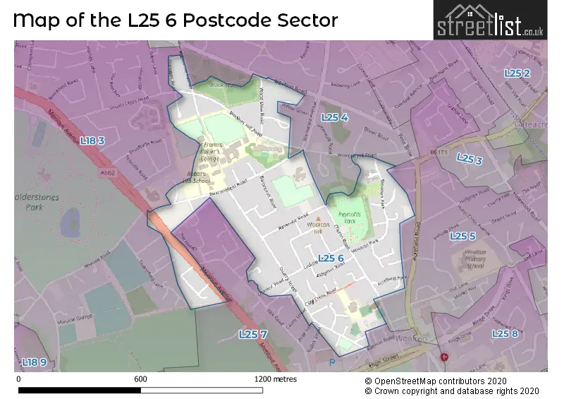
The L25 6 Postcode shares a border with L18 3 (LIVERPOOL, Mossley Hill, Allerton), L25 4 (LIVERPOOL, Woolton, Gateacre), L25 5 (LIVERPOOL, Woolton, Gateacre) and L25 7 (Woolton, LIVERPOOL).
Map of the L25 6 Postcode Sector
Explore the L25 6 postcode sector by using our interactive map.
The sector is within the post town of LIVERPOOL.
L25 6 is a postcode sector within the L25 postcode district which is within the L Liverpool postcode area.
The Royal Mail delivery office for the L25 6 postal sector is the Woolton Delivery Office.
The area of the L25 6 postcode sector is 0.36 square miles which is 0.93 square kilometres or 229.04 square acres.
Your support helps keep this site running!
If you enjoy using this website, consider buying me a coffee to help cover hosting costs.


| L | 2 | 5 | - | 6 | X | X |
| L | 2 | 5 | Space | 6 | Letter | Letter |
Official List of Streets
LIVERPOOL (39 Streets)
Woolton (5 Streets)
(2 Streets)
Unofficial Streets or Alternative Spellings
LIVERPOOL
BLACKWOOD AVENUE CALDER GRANGE COBDEN VIEW DEERBOURNE CLOSE DRUIDS CROSS ROAD GLENROSE ROAD MERRION CLOSE MIDDLEFIELD ROAD PARKWOOD ROAD RODICK STREET ROSE STREET WILLOW GREEN WOOLTON MOUNTWoolton
BADDOW CROFT BOWER ROAD BYRON COURT CASTLE STREET COBDEN STREET GLADSTONE STREET VALE ROAD WOOLTON HILL ROAD GLENACRES MILL STYLE SAINT MARYS COURT ST MARYS COURT STONEMASONS COURTChildwall
WOOLTON ROADWeather Forecast for L25 6
Weather Forecast for Woolton
| Time Period | Icon | Description | Temperature | Rain Probability | Wind |
|---|---|---|---|---|---|
| 12:00 to 15:00 | Cloudy | 9.0°C (feels like 6.0°C) | 5.00% | S 9 mph | |
| 15:00 to 18:00 | Cloudy | 10.0°C (feels like 7.0°C) | 5.00% | S 11 mph | |
| 18:00 to 21:00 | Cloudy | 8.0°C (feels like 6.0°C) | 5.00% | S 9 mph | |
| 21:00 to 00:00 | Cloudy | 8.0°C (feels like 5.0°C) | 8.00% | SSE 11 mph |
| Time Period | Icon | Description | Temperature | Rain Probability | Wind |
|---|---|---|---|---|---|
| 00:00 to 03:00 | Cloudy | 8.0°C (feels like 4.0°C) | 5.00% | S 13 mph | |
| 03:00 to 06:00 | Cloudy | 8.0°C (feels like 5.0°C) | 8.00% | S 13 mph | |
| 06:00 to 09:00 | Cloudy | 8.0°C (feels like 5.0°C) | 6.00% | S 13 mph | |
| 09:00 to 12:00 | Cloudy | 9.0°C (feels like 6.0°C) | 10.00% | S 13 mph | |
| 12:00 to 15:00 | Overcast | 9.0°C (feels like 6.0°C) | 17.00% | S 16 mph | |
| 15:00 to 18:00 | Cloudy | 9.0°C (feels like 6.0°C) | 50.00% | WSW 13 mph | |
| 18:00 to 21:00 | Clear night | 8.0°C (feels like 4.0°C) | 5.00% | SW 13 mph | |
| 21:00 to 00:00 | Clear night | 6.0°C (feels like 3.0°C) | 2.00% | WSW 13 mph |
| Time Period | Icon | Description | Temperature | Rain Probability | Wind |
|---|---|---|---|---|---|
| 00:00 to 03:00 | Clear night | 6.0°C (feels like 2.0°C) | 0.00% | WSW 11 mph | |
| 03:00 to 06:00 | Clear night | 5.0°C (feels like 2.0°C) | 0.00% | WSW 11 mph | |
| 06:00 to 09:00 | Light rain shower (night) | 5.0°C (feels like 2.0°C) | 31.00% | W 11 mph | |
| 09:00 to 12:00 | Cloudy | 6.0°C (feels like 3.0°C) | 4.00% | W 9 mph | |
| 12:00 to 15:00 | Cloudy | 7.0°C (feels like 4.0°C) | 6.00% | W 11 mph | |
| 15:00 to 18:00 | Sunny day | 7.0°C (feels like 5.0°C) | 1.00% | WNW 9 mph | |
| 18:00 to 21:00 | Clear night | 5.0°C (feels like 3.0°C) | 1.00% | W 4 mph | |
| 21:00 to 00:00 | Clear night | 3.0°C (feels like 2.0°C) | 1.00% | WSW 2 mph |
| Time Period | Icon | Description | Temperature | Rain Probability | Wind |
|---|---|---|---|---|---|
| 00:00 to 03:00 | Clear night | 2.0°C (feels like 0.0°C) | 0.00% | SSE 2 mph | |
| 03:00 to 06:00 | Clear night | 1.0°C (feels like -1.0°C) | 1.00% | SE 4 mph | |
| 06:00 to 09:00 | Clear night | 0.0°C (feels like -3.0°C) | 3.00% | SE 4 mph | |
| 09:00 to 12:00 | Sunny day | 1.0°C (feels like -3.0°C) | 3.00% | SE 7 mph | |
| 12:00 to 15:00 | Sunny day | 4.0°C (feels like 2.0°C) | 0.00% | SE 7 mph | |
| 15:00 to 18:00 | Sunny day | 7.0°C (feels like 5.0°C) | 0.00% | ESE 7 mph | |
| 18:00 to 21:00 | Clear night | 5.0°C (feels like 2.0°C) | 0.00% | ESE 7 mph | |
| 21:00 to 00:00 | Clear night | 3.0°C (feels like 0.0°C) | 0.00% | ESE 9 mph |
| Time Period | Icon | Description | Temperature | Rain Probability | Wind |
|---|---|---|---|---|---|
| 00:00 to 03:00 | Clear night | 2.0°C (feels like -1.0°C) | 1.00% | ESE 9 mph | |
| 03:00 to 06:00 | Clear night | 1.0°C (feels like -2.0°C) | 2.00% | ESE 9 mph | |
| 06:00 to 09:00 | Clear night | 1.0°C (feels like -3.0°C) | 3.00% | ESE 7 mph | |
| 09:00 to 12:00 | Sunny day | 1.0°C (feels like -2.0°C) | 4.00% | ESE 7 mph | |
| 12:00 to 15:00 | Sunny day | 4.0°C (feels like 1.0°C) | 2.00% | ESE 9 mph | |
| 15:00 to 18:00 | Sunny day | 6.0°C (feels like 3.0°C) | 1.00% | ESE 9 mph | |
| 18:00 to 21:00 | Clear night | 4.0°C (feels like 1.0°C) | 1.00% | E 7 mph | |
| 21:00 to 00:00 | Clear night | 2.0°C (feels like -1.0°C) | 1.00% | ESE 9 mph |
Schools and Places of Education Within the L25 6 Postcode Sector
Abbot's Lea School
Community special school
Beaconsfield Road, Liverpool, Merseyside, L25 6EE
Head: Mrs Ania Hildrey
Ofsted Rating: Requires improvement
Inspection: 2021-11-03 (1188 days ago)
Website: Visit Abbot's Lea School Website
Phone: 01514281161
Number of Pupils: 271
SENDSCOPE
Other independent special school
The Pavillion, Liverpool, Merseyside, L25 6EG
Head: Miss Natalie Walsh
Ofsted Rating: Good
Inspection: 2023-10-19 (473 days ago)
Website: Visit SENDSCOPE Website
Phone: 07951942587
Number of Pupils: 1
Woolton High School
Community special school
Woolton Hill Road, Liverpool, Merseyside, L25 6JA
Head: Mr ME Christian
Ofsted Rating: Good
Inspection: 2018-09-11 (2337 days ago)
Website: Visit Woolton High School Website
Phone: 01513305120
Number of Pupils: 73
House Prices in the L25 6 Postcode Sector
| Type of Property | 2018 Average | 2018 Sales | 2017 Average | 2017 Sales | 2016 Average | 2016 Sales | 2015 Average | 2015 Sales |
|---|---|---|---|---|---|---|---|---|
| Detached | £520,098 | 27 | £554,486 | 21 | £496,429 | 14 | £491,619 | 21 |
| Semi-Detached | £363,334 | 16 | £309,488 | 21 | £263,666 | 12 | £280,200 | 20 |
| Terraced | £198,222 | 9 | £0 | 0 | £213,057 | 7 | £184,130 | 9 |
| Flats | £148,444 | 9 | £117,229 | 12 | £107,589 | 14 | £119,499 | 6 |
Important Postcodes L25 6 in the Postcode Sector
L25 6EE is the postcode for NEW CLASSROOM BLOCK, Palmerston School, Beaconsfield Road, MAIN SCHOOL BUILDING, Abbots Lea Special School, Beaconsfield Road, Abbots Lea Special School, Beaconsfield Road, Palmerston School, Beaconsfield Road, HOUSE, Abbots Lea Special School, Beaconsfield Road, and NEW CLASSROOM BLOCK, Abbots Lea Special School, Beaconsfield Road
L25 6EG is the postcode for LEMAITRE BUILDING, St. Francis Xaviers College, Woolton Hill Road, NEWMAN BUILDING, St. Francis Xaviers College, Woolton Hill Road, NUGENT BUILDING, St. Francis Xaviers College, Woolton Hill Road, St. Francis Xaviers College, Woolton Hill Road, and DE LA MENNAIS BUILDING, St. Francis Xaviers College, Woolton Hill Road
L25 6JA is the postcode for WOOLTON HIGH SCHOOL, WOOLTON HILL ROAD, LIVERPOOL, HOUSE TYPE 1, Woolton High School, Woolton Hill Road, Woolton High School, Woolton Hill Road, HOUSE TYPE 2 EAST, Woolton High School, Woolton Hill Road, and HOUSE TYPE 2 WEST, Woolton High School, Woolton Hill Road
| The L25 6 Sector is within these Local Authorities |
|
|---|---|
| The L25 6 Sector is within these Counties |
|
| The L25 6 Sector is within these Water Company Areas |
|