A wide range of spatial data has been analysed to present this overview of the L19 5 Postcode sector. If you would like anything added, please contact us.
The L19 5 postcode sector is within the county of Merseyside.
Did you know? According to the 2021 Census, the L19 5 postcode sector is home to a bustling 1,454 residents!
Given that each sector allows for 400 unique postcode combinations. Letters C, I, K, M, O and V are not allowed in the last two letters of a postcode. With 29 postcodes already in use, this leaves 371 units available.
The largest settlement in the L19 5 postal code is LIVERPOOL followed by Allerton, and Garston.
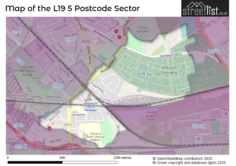
The L19 5 Postcode shares a border with L19 6 (LIVERPOOL, Garston), L19 4 (LIVERPOOL, Garston), L24 9 (LIVERPOOL, Speke, Halewood), L19 1 (LIVERPOOL, Garston), L19 2 (LIVERPOOL, Garston) and L25 7 (Woolton, LIVERPOOL).
Map of the L19 5 Postcode Sector
Explore the L19 5 postcode sector by using our interactive map.
The sector is within the post town of LIVERPOOL.
L19 5 is a postcode sector within the L19 postcode district which is within the L Liverpool postcode area.
The Royal Mail delivery office for the L19 5 postal sector is the Garston Delivery Office.
The area of the L19 5 postcode sector is 0.41 square miles which is 1.06 square kilometres or 260.74 square acres.
Your support helps keep this site running!
If you enjoy using this website, consider buying me a coffee to help cover hosting costs.


| L | 1 | 9 | - | 5 | X | X |
| L | 1 | 9 | Space | 5 | Letter | Letter |
Official List of Streets
LIVERPOOL (17 Streets)
(2 Streets)
Allerton (3 Streets)
Unofficial Streets or Alternative Spellings
Weather Forecast for L19 5
Weather Forecast for Allerton (Merseyside)
| Time Period | Icon | Description | Temperature | Rain Probability | Wind |
|---|---|---|---|---|---|
| 06:00 to 09:00 | Clear night | 4.0°C (feels like 1.0°C) | 3.00% | NW 9 mph | |
| 09:00 to 12:00 | Sunny day | 4.0°C (feels like 1.0°C) | 1.00% | NW 9 mph | |
| 12:00 to 15:00 | Partly cloudy (day) | 6.0°C (feels like 3.0°C) | 3.00% | WNW 11 mph | |
| 15:00 to 18:00 | Partly cloudy (day) | 6.0°C (feels like 3.0°C) | 9.00% | WNW 11 mph | |
| 18:00 to 21:00 | Clear night | 4.0°C (feels like 2.0°C) | 1.00% | WSW 7 mph | |
| 21:00 to 00:00 | Cloudy | 4.0°C (feels like 1.0°C) | 4.00% | SSW 7 mph |
| Time Period | Icon | Description | Temperature | Rain Probability | Wind |
|---|---|---|---|---|---|
| 00:00 to 03:00 | Cloudy | 4.0°C (feels like 1.0°C) | 56.00% | S 9 mph | |
| 03:00 to 06:00 | Heavy rain | 4.0°C (feels like 0.0°C) | 85.00% | S 11 mph | |
| 06:00 to 09:00 | Light rain | 5.0°C (feels like 2.0°C) | 56.00% | WSW 11 mph | |
| 09:00 to 12:00 | Partly cloudy (day) | 6.0°C (feels like 2.0°C) | 9.00% | NW 11 mph | |
| 12:00 to 15:00 | Overcast | 7.0°C (feels like 4.0°C) | 8.00% | NNW 9 mph | |
| 15:00 to 18:00 | Cloudy | 7.0°C (feels like 5.0°C) | 5.00% | W 7 mph | |
| 18:00 to 21:00 | Cloudy | 5.0°C (feels like 3.0°C) | 5.00% | SW 4 mph | |
| 21:00 to 00:00 | Overcast | 4.0°C (feels like 2.0°C) | 8.00% | ESE 7 mph |
| Time Period | Icon | Description | Temperature | Rain Probability | Wind |
|---|---|---|---|---|---|
| 00:00 to 03:00 | Cloudy | 3.0°C (feels like 0.0°C) | 6.00% | SE 7 mph | |
| 03:00 to 06:00 | Cloudy | 3.0°C (feels like 0.0°C) | 7.00% | SE 9 mph | |
| 06:00 to 09:00 | Overcast | 3.0°C (feels like -1.0°C) | 9.00% | SE 9 mph | |
| 09:00 to 12:00 | Overcast | 3.0°C (feels like -1.0°C) | 8.00% | SE 11 mph | |
| 12:00 to 15:00 | Overcast | 6.0°C (feels like 2.0°C) | 9.00% | SSE 13 mph | |
| 15:00 to 18:00 | Overcast | 7.0°C (feels like 3.0°C) | 9.00% | SSE 13 mph | |
| 18:00 to 21:00 | Cloudy | 6.0°C (feels like 2.0°C) | 6.00% | SSE 13 mph | |
| 21:00 to 00:00 | Cloudy | 6.0°C (feels like 2.0°C) | 8.00% | SSE 16 mph |
| Time Period | Icon | Description | Temperature | Rain Probability | Wind |
|---|---|---|---|---|---|
| 00:00 to 03:00 | Cloudy | 5.0°C (feels like 1.0°C) | 11.00% | SSE 16 mph | |
| 03:00 to 06:00 | Overcast | 5.0°C (feels like 1.0°C) | 18.00% | SSE 16 mph | |
| 06:00 to 09:00 | Overcast | 5.0°C (feels like 1.0°C) | 22.00% | S 13 mph | |
| 09:00 to 12:00 | Cloudy | 5.0°C (feels like 1.0°C) | 21.00% | SSW 11 mph | |
| 12:00 to 15:00 | Cloudy | 6.0°C (feels like 3.0°C) | 15.00% | SSW 11 mph | |
| 15:00 to 18:00 | Overcast | 7.0°C (feels like 4.0°C) | 13.00% | SSW 11 mph | |
| 18:00 to 21:00 | Cloudy | 6.0°C (feels like 3.0°C) | 8.00% | SW 9 mph | |
| 21:00 to 00:00 | Clear night | 5.0°C (feels like 2.0°C) | 3.00% | SSW 9 mph |
Schools and Places of Education Within the L19 5 Postcode Sector
Garston Church of England Primary School
Academy sponsor led
Holman Road, Liverpool, Merseyside, L19 5NS
Head: Ms Sarah Knipe
Ofsted Rating: Good
Inspection: 2022-09-14 (869 days ago)
Website: Visit Garston Church of England Primary School Website
Phone: 01514277517
Number of Pupils: 230
The Academy of St Nicholas
Academy sponsor led
51 Horrocks Avenue, Liverpool, Merseyside, L19 5NY
Head: Mr Gary Lloyd
Ofsted Rating: Good
Inspection: 2022-12-07 (785 days ago)
Website: Visit The Academy of St Nicholas Website
Phone: 01512302570
Number of Pupils: 901
House Prices in the L19 5 Postcode Sector
| Type of Property | 2018 Average | 2018 Sales | 2017 Average | 2017 Sales | 2016 Average | 2016 Sales | 2015 Average | 2015 Sales |
|---|---|---|---|---|---|---|---|---|
| Detached | £0 | 0 | £199,000 | 1 | £0 | 0 | £0 | 0 |
| Semi-Detached | £177,300 | 10 | £155,673 | 13 | £146,695 | 10 | £143,500 | 4 |
| Terraced | £130,931 | 8 | £124,983 | 3 | £113,700 | 10 | £117,136 | 11 |
| Flats | £0 | 0 | £62,000 | 1 | £58,000 | 1 | £60,250 | 2 |
Important Postcodes L19 5 in the Postcode Sector
L19 5NG is the postcode for Heys Court, 18 Woolton Road
L19 5NS is the postcode for Garston C of E Primary School, Holman Road
L19 5NY is the postcode for The Academy of St. Nicholas, Horrocks Avenue, MAIN BUILDING, The Academy of St. Nicholas, Horrocks Avenue, and SPORTS HALL, The Academy of St. Nicholas, Horrocks Avenue
| The L19 5 Sector is within these Local Authorities |
|
|---|---|
| The L19 5 Sector is within these Counties |
|
| The L19 5 Sector is within these Water Company Areas |
|