A wide range of spatial data has been analysed to present this overview of the L15 7 Postcode sector. If you would like anything added, please contact us.
The L15 7 postcode sector is within the county of Merseyside.
Did you know? According to the 2021 Census, the L15 7 postcode sector is home to a bustling 2,984 residents!
Given that each sector allows for 400 unique postcode combinations. Letters C, I, K, M, O and V are not allowed in the last two letters of a postcode. With 48 postcodes already in use, this leaves 352 units available.
The largest settlements in the L15 7 postal code are LIVERPOOL and Wavertree.
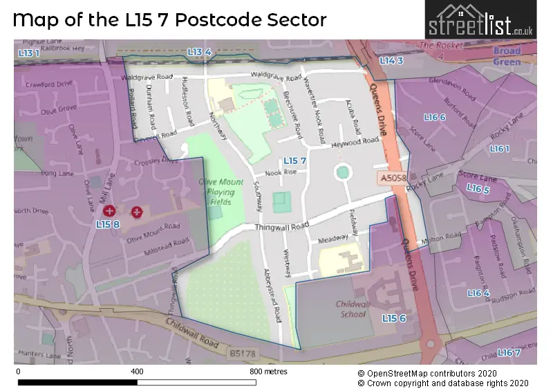
The L15 7 Postcode shares a border with L13 4 (LIVERPOOL, Old Swan, Stoneycroft), L15 6 (LIVERPOOL, Wavertree), L16 6 (LIVERPOOL, Childwall), L14 3 (LIVERPOOL, Broadgreen, Bowring Park) and L15 8 (LIVERPOOL, Wavertree).
Map of the L15 7 Postcode Sector
Explore the L15 7 postcode sector by using our interactive map.
The sector is within the post town of LIVERPOOL.
L15 7 is a postcode sector within the L15 postcode district which is within the L Liverpool postcode area.
The Royal Mail delivery office for the L15 7 postal sector is the South Eastern (l) Delivery Office.
The area of the L15 7 postcode sector is 0.24 square miles which is 0.63 square kilometres or 154.59 square acres.
Your support helps keep this site running!
If you enjoy using this website, consider buying me a coffee to help cover hosting costs.


| L | 1 | 5 | - | 7 | X | X |
| L | 1 | 5 | Space | 7 | Letter | Letter |
Official List of Streets
LIVERPOOL (17 Streets)
Unofficial Streets or Alternative Spellings
LIVERPOOL
CROSSLEY DRIVE GLENLYON ROAD MOLTON ROAD SCORE LANE STURDEE ROAD SWAN CRESCENTMossley Hill
QUEENS DRIVEChildwall
GLENDEVON ROAD ROCKY LANE ELOWEN CLOSE HEYWOOD COURT QUEENS DRIVE (WAVERTREE) QUEENS DRIVE STONEYCROFTWavertree
CHARNLEY DRIVEWeather Forecast for L15 7
Weather Forecast for Wavertree
| Time Period | Icon | Description | Temperature | Rain Probability | Wind |
|---|---|---|---|---|---|
| 03:00 to 06:00 | Cloudy | 6.0°C (feels like 3.0°C) | 13.00% | SSE 13 mph | |
| 06:00 to 09:00 | Light rain | 6.0°C (feels like 3.0°C) | 44.00% | N 13 mph | |
| 09:00 to 12:00 | Light rain shower (day) | 6.0°C (feels like 3.0°C) | 39.00% | NNW 16 mph | |
| 12:00 to 15:00 | Cloudy | 7.0°C (feels like 3.0°C) | 15.00% | NW 18 mph | |
| 15:00 to 18:00 | Cloudy | 7.0°C (feels like 3.0°C) | 12.00% | NW 18 mph | |
| 18:00 to 21:00 | Cloudy | 7.0°C (feels like 3.0°C) | 9.00% | NW 18 mph | |
| 21:00 to 00:00 | Partly cloudy (night) | 6.0°C (feels like 2.0°C) | 6.00% | WNW 16 mph |
| Time Period | Icon | Description | Temperature | Rain Probability | Wind |
|---|---|---|---|---|---|
| 00:00 to 03:00 | Partly cloudy (night) | 6.0°C (feels like 2.0°C) | 6.00% | W 13 mph | |
| 03:00 to 06:00 | Cloudy | 5.0°C (feels like 1.0°C) | 7.00% | WSW 11 mph | |
| 06:00 to 09:00 | Cloudy | 4.0°C (feels like 1.0°C) | 7.00% | S 7 mph | |
| 09:00 to 12:00 | Cloudy | 3.0°C (feels like 0.0°C) | 7.00% | SSE 9 mph | |
| 12:00 to 15:00 | Cloudy | 5.0°C (feels like 2.0°C) | 8.00% | ENE 9 mph | |
| 15:00 to 18:00 | Cloudy | 6.0°C (feels like 3.0°C) | 11.00% | NE 11 mph | |
| 18:00 to 21:00 | Cloudy | 5.0°C (feels like 2.0°C) | 10.00% | NE 11 mph | |
| 21:00 to 00:00 | Cloudy | 5.0°C (feels like 2.0°C) | 10.00% | NNE 11 mph |
| Time Period | Icon | Description | Temperature | Rain Probability | Wind |
|---|---|---|---|---|---|
| 00:00 to 03:00 | Cloudy | 5.0°C (feels like 1.0°C) | 11.00% | NNE 11 mph | |
| 03:00 to 06:00 | Cloudy | 4.0°C (feels like 1.0°C) | 9.00% | NNE 11 mph | |
| 06:00 to 09:00 | Clear night | 4.0°C (feels like 1.0°C) | 4.00% | NNE 11 mph | |
| 09:00 to 12:00 | Sunny day | 4.0°C (feels like 1.0°C) | 3.00% | NNE 9 mph | |
| 12:00 to 15:00 | Sunny day | 6.0°C (feels like 3.0°C) | 2.00% | N 9 mph | |
| 15:00 to 18:00 | Sunny day | 7.0°C (feels like 4.0°C) | 3.00% | NNE 9 mph | |
| 18:00 to 21:00 | Partly cloudy (night) | 5.0°C (feels like 3.0°C) | 3.00% | NW 7 mph | |
| 21:00 to 00:00 | Partly cloudy (night) | 5.0°C (feels like 2.0°C) | 3.00% | NW 9 mph |
Schools and Places of Education Within the L15 7 Postcode Sector
Christ The King Catholic Primary School
Voluntary aided school
Meadway, Liverpool, Merseyside, L15 7LZ
Head: Mr D Delaney
Ofsted Rating: Good
Inspection: 2018-11-06 (2275 days ago)
Website: Visit Christ The King Catholic Primary School Website
Phone: 01517223462
Number of Pupils: 411
Northway Primary and Nursery School
Community school
Northway, Liverpool, Merseyside, L15 7JQ
Head: Mr MJ Hargreaves
Ofsted Rating: Requires improvement
Inspection: 2022-12-07 (783 days ago)
Website: Visit Northway Primary and Nursery School Website
Phone: 01517223540
Number of Pupils: 410
House Prices in the L15 7 Postcode Sector
| Type of Property | 2018 Average | 2018 Sales | 2017 Average | 2017 Sales | 2016 Average | 2016 Sales | 2015 Average | 2015 Sales |
|---|---|---|---|---|---|---|---|---|
| Detached | £0 | 0 | £231,000 | 2 | £0 | 0 | £239,062 | 3 |
| Semi-Detached | £179,406 | 16 | £238,132 | 19 | £208,933 | 15 | £190,802 | 21 |
| Terraced | £210,175 | 14 | £179,175 | 14 | £170,727 | 18 | £176,544 | 13 |
| Flats | £174,500 | 2 | £117,500 | 1 | £151,750 | 2 | £126,225 | 2 |
Important Postcodes L15 7 in the Postcode Sector
L15 7JQ is the postcode for Northway Primary & Infant School, Northway, Northway Primary & Nursery School, Northway, Wavertree, and Northway Primary And Nursery School, Northway
L15 7LZ is the postcode for CHRIST THE KING CATHOLIC PRIMARY SCHOOL, MEADWAY, LIVERPOOL, Christ the King RC Primary School, Meadway, Wavertree, and Christ the King RC Primary School, Meadway
| The L15 7 Sector is within these Local Authorities |
|
|---|---|
| The L15 7 Sector is within these Counties |
|
| The L15 7 Sector is within these Water Company Areas |
|