A wide range of spatial data has been analysed to present this overview of the L12 6 Postcode sector. If you would like anything added, please contact us.
The L12 6 postcode sector is within the county of Merseyside.
Did you know? According to the 2021 Census, the L12 6 postcode sector is home to a bustling 1,989 residents!
Given that each sector allows for 400 unique postcode combinations. Letters C, I, K, M, O and V are not allowed in the last two letters of a postcode. With 37 postcodes already in use, this leaves 363 units available.
The L12 6 postal code covers the settlement of LIVERPOOL.
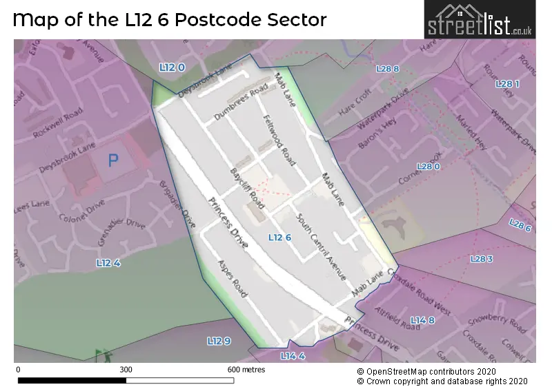
The L12 6 Postcode shares a border with L12 4 (LIVERPOOL, West Derby), L28 8 (LIVERPOOL), L12 9 (LIVERPOOL, West Derby), L12 0 (LIVERPOOL, West Derby), L14 4 (LIVERPOOL, Knotty Ash), L14 8 (LIVERPOOL), L28 3 (LIVERPOOL) and L28 0 (LIVERPOOL).
Map of the L12 6 Postcode Sector
Explore the L12 6 postcode sector by using our interactive map.
The sector is within the post town of LIVERPOOL.
L12 6 is a postcode sector within the L12 postcode district which is within the L Liverpool postcode area.
The Royal Mail delivery office for the L12 6 postal sector is the West Derby Delivery Office.
The area of the L12 6 postcode sector is 0.13 square miles which is 0.34 square kilometres or 84.35 square acres.
Your support helps keep this site running!
If you enjoy using this website, consider buying me a coffee to help cover hosting costs.


| L | 1 | 2 | - | 6 | X | X |
| L | 1 | 2 | Space | 6 | Letter | Letter |
Official List of Streets
LIVERPOOL (19 Streets)
Unofficial Streets or Alternative Spellings
LIVERPOOL
BRIGADIER DRIVE COACHMANS DRIVE CORNER BROOK CROXDALE ROAD WEST WATERPARK DRIVEKnotty Ash
FINCH LANEWeather Forecast for L12 6
Weather Forecast for Croxteth Hall
| Time Period | Icon | Description | Temperature | Rain Probability | Wind |
|---|---|---|---|---|---|
| 09:00 to 12:00 | Cloudy | 3.0°C (feels like 0.0°C) | 4.00% | SSE 9 mph | |
| 12:00 to 15:00 | Cloudy | 6.0°C (feels like 2.0°C) | 3.00% | SSE 13 mph | |
| 15:00 to 18:00 | Cloudy | 7.0°C (feels like 3.0°C) | 3.00% | SSE 13 mph | |
| 18:00 to 21:00 | Cloudy | 6.0°C (feels like 2.0°C) | 3.00% | SSE 13 mph | |
| 21:00 to 00:00 | Cloudy | 5.0°C (feels like 1.0°C) | 5.00% | SSE 13 mph |
| Time Period | Icon | Description | Temperature | Rain Probability | Wind |
|---|---|---|---|---|---|
| 00:00 to 03:00 | Cloudy | 5.0°C (feels like 1.0°C) | 10.00% | SSE 16 mph | |
| 03:00 to 06:00 | Cloudy | 5.0°C (feels like 0.0°C) | 7.00% | SSE 16 mph | |
| 06:00 to 09:00 | Cloudy | 5.0°C (feels like 0.0°C) | 11.00% | SSE 13 mph | |
| 09:00 to 12:00 | Overcast | 5.0°C (feels like 1.0°C) | 13.00% | SSE 13 mph | |
| 12:00 to 15:00 | Overcast | 6.0°C (feels like 2.0°C) | 13.00% | SSE 11 mph | |
| 15:00 to 18:00 | Overcast | 6.0°C (feels like 4.0°C) | 13.00% | S 9 mph | |
| 18:00 to 21:00 | Cloudy | 6.0°C (feels like 3.0°C) | 6.00% | S 9 mph | |
| 21:00 to 00:00 | Cloudy | 6.0°C (feels like 3.0°C) | 5.00% | S 9 mph |
| Time Period | Icon | Description | Temperature | Rain Probability | Wind |
|---|---|---|---|---|---|
| 00:00 to 03:00 | Cloudy | 5.0°C (feels like 3.0°C) | 5.00% | S 9 mph | |
| 03:00 to 06:00 | Cloudy | 5.0°C (feels like 2.0°C) | 5.00% | S 9 mph | |
| 06:00 to 09:00 | Cloudy | 4.0°C (feels like 1.0°C) | 5.00% | SSE 11 mph | |
| 09:00 to 12:00 | Cloudy | 5.0°C (feels like 1.0°C) | 4.00% | SSE 11 mph | |
| 12:00 to 15:00 | Cloudy | 7.0°C (feels like 4.0°C) | 5.00% | S 11 mph | |
| 15:00 to 18:00 | Cloudy | 9.0°C (feels like 6.0°C) | 5.00% | S 13 mph | |
| 18:00 to 21:00 | Cloudy | 8.0°C (feels like 5.0°C) | 7.00% | S 13 mph | |
| 21:00 to 00:00 | Cloudy | 8.0°C (feels like 4.0°C) | 9.00% | S 16 mph |
| Time Period | Icon | Description | Temperature | Rain Probability | Wind |
|---|---|---|---|---|---|
| 00:00 to 03:00 | Cloudy | 8.0°C (feels like 4.0°C) | 17.00% | S 16 mph | |
| 03:00 to 06:00 | Cloudy | 8.0°C (feels like 4.0°C) | 21.00% | S 16 mph | |
| 06:00 to 09:00 | Cloudy | 8.0°C (feels like 5.0°C) | 23.00% | S 16 mph | |
| 09:00 to 12:00 | Cloudy | 8.0°C (feels like 5.0°C) | 21.00% | SSW 16 mph | |
| 12:00 to 15:00 | Cloudy | 9.0°C (feels like 6.0°C) | 20.00% | SW 13 mph | |
| 15:00 to 18:00 | Cloudy | 9.0°C (feels like 6.0°C) | 15.00% | SW 13 mph | |
| 18:00 to 21:00 | Partly cloudy (night) | 8.0°C (feels like 4.0°C) | 8.00% | SW 13 mph | |
| 21:00 to 00:00 | Clear night | 7.0°C (feels like 4.0°C) | 4.00% | WSW 16 mph |
Schools and Places of Education Within the L12 6 Postcode Sector
Mab Lane Junior Mixed and Infant School
Community school
Mab Lane, Liverpool, Merseyside, L12 6QL
Head: Mrs Laura Tracey
Ofsted Rating: Good
Inspection: 2020-01-15 (1844 days ago)
Website: Visit Mab Lane Junior Mixed and Infant School Website
Phone: 01512594282
Number of Pupils: 312
House Prices in the L12 6 Postcode Sector
| Type of Property | 2018 Average | 2018 Sales | 2017 Average | 2017 Sales | 2016 Average | 2016 Sales | 2015 Average | 2015 Sales |
|---|---|---|---|---|---|---|---|---|
| Detached | £0 | 0 | £0 | 0 | £0 | 0 | £0 | 0 |
| Semi-Detached | £117,133 | 9 | £116,000 | 1 | £0 | 0 | £96,250 | 4 |
| Terraced | £94,545 | 11 | £83,700 | 5 | £82,000 | 10 | £67,820 | 10 |
| Flats | £71,625 | 4 | £66,333 | 3 | £51,500 | 6 | £49,118 | 5 |
Important Postcodes L12 6 in the Postcode Sector
L12 6QL is the postcode for Mab Lane Jmi School, Mab Lane
| The L12 6 Sector is within these Local Authorities |
|
|---|---|
| The L12 6 Sector is within these Counties |
|
| The L12 6 Sector is within these Water Company Areas |
|