A wide range of spatial data has been analysed to present this overview of the L11 4 Postcode sector. If you would like anything added, please contact us.
The L11 4 postcode sector is within the county of Merseyside.
Did you know? According to the 2021 Census, the L11 4 postcode sector is home to a bustling 3,046 residents!
Given that each sector allows for 400 unique postcode combinations. Letters C, I, K, M, O and V are not allowed in the last two letters of a postcode. With 68 postcodes already in use, this leaves 332 units available.
The largest settlements in the L11 4 postal code are LIVERPOOL and Croxteth.
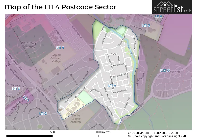
The L11 4 Postcode shares a border with L11 0 (LIVERPOOL, Gilmoss Industrial Estate, West Derby), L11 2 (LIVERPOOL, West Derby), L11 9 (LIVERPOOL, Croxteth) and L12 0 (LIVERPOOL, West Derby).
Map of the L11 4 Postcode Sector
Explore the L11 4 postcode sector by using our interactive map.
The sector is within the post town of LIVERPOOL.
L11 4 is a postcode sector within the L11 postcode district which is within the L Liverpool postcode area.
The Royal Mail delivery office for the L11 4 postal sector is the West Derby Delivery Office.
The area of the L11 4 postcode sector is 0.21 square miles which is 0.54 square kilometres or 133.10 square acres.
Your support helps keep this site running!
If you enjoy using this website, consider buying me a coffee to help cover hosting costs.


| L | 1 | 1 | - | 4 | X | X |
| L | 1 | 1 | Space | 4 | Letter | Letter |
Official List of Streets
LIVERPOOL (48 Streets)
Croxteth (2 Streets)
(4 Streets)
Unofficial Streets or Alternative Spellings
Weather Forecast for L11 4
Weather Forecast for Croxteth Hall
| Time Period | Icon | Description | Temperature | Rain Probability | Wind |
|---|---|---|---|---|---|
| 18:00 to 21:00 | Cloudy | 6.0°C (feels like 2.0°C) | 3.00% | SSE 11 mph | |
| 21:00 to 00:00 | Cloudy | 5.0°C (feels like 1.0°C) | 5.00% | SSE 11 mph |
| Time Period | Icon | Description | Temperature | Rain Probability | Wind |
|---|---|---|---|---|---|
| 00:00 to 03:00 | Overcast | 6.0°C (feels like 2.0°C) | 8.00% | SSE 13 mph | |
| 03:00 to 06:00 | Cloudy | 5.0°C (feels like 1.0°C) | 5.00% | SSE 13 mph | |
| 06:00 to 09:00 | Cloudy | 5.0°C (feels like 0.0°C) | 5.00% | SSE 13 mph | |
| 09:00 to 12:00 | Cloudy | 5.0°C (feels like 1.0°C) | 10.00% | SSE 13 mph | |
| 12:00 to 15:00 | Overcast | 6.0°C (feels like 3.0°C) | 11.00% | SSE 11 mph | |
| 15:00 to 18:00 | Overcast | 7.0°C (feels like 4.0°C) | 14.00% | SSE 7 mph | |
| 18:00 to 21:00 | Overcast | 7.0°C (feels like 5.0°C) | 13.00% | S 7 mph | |
| 21:00 to 00:00 | Cloudy | 6.0°C (feels like 4.0°C) | 5.00% | S 7 mph |
| Time Period | Icon | Description | Temperature | Rain Probability | Wind |
|---|---|---|---|---|---|
| 00:00 to 03:00 | Cloudy | 6.0°C (feels like 3.0°C) | 8.00% | S 7 mph | |
| 03:00 to 06:00 | Cloudy | 5.0°C (feels like 2.0°C) | 4.00% | SSE 9 mph | |
| 06:00 to 09:00 | Cloudy | 4.0°C (feels like 1.0°C) | 4.00% | SSE 9 mph | |
| 09:00 to 12:00 | Cloudy | 4.0°C (feels like 1.0°C) | 4.00% | SSE 11 mph | |
| 12:00 to 15:00 | Cloudy | 7.0°C (feels like 4.0°C) | 4.00% | SSE 11 mph | |
| 15:00 to 18:00 | Cloudy | 9.0°C (feels like 6.0°C) | 4.00% | S 11 mph | |
| 18:00 to 21:00 | Cloudy | 8.0°C (feels like 5.0°C) | 4.00% | S 13 mph | |
| 21:00 to 00:00 | Cloudy | 7.0°C (feels like 3.0°C) | 4.00% | SSE 13 mph |
| Time Period | Icon | Description | Temperature | Rain Probability | Wind |
|---|---|---|---|---|---|
| 00:00 to 03:00 | Cloudy | 7.0°C (feels like 4.0°C) | 5.00% | S 13 mph | |
| 03:00 to 06:00 | Cloudy | 8.0°C (feels like 4.0°C) | 5.00% | S 16 mph | |
| 06:00 to 09:00 | Cloudy | 8.0°C (feels like 5.0°C) | 10.00% | S 16 mph | |
| 09:00 to 12:00 | Cloudy | 9.0°C (feels like 5.0°C) | 16.00% | S 16 mph | |
| 12:00 to 15:00 | Cloudy | 9.0°C (feels like 6.0°C) | 22.00% | SSW 16 mph | |
| 15:00 to 18:00 | Cloudy | 9.0°C (feels like 6.0°C) | 20.00% | SW 13 mph | |
| 18:00 to 21:00 | Clear night | 8.0°C (feels like 5.0°C) | 11.00% | SW 13 mph | |
| 21:00 to 00:00 | Clear night | 7.0°C (feels like 4.0°C) | 6.00% | WSW 13 mph |
| Time Period | Icon | Description | Temperature | Rain Probability | Wind |
|---|---|---|---|---|---|
| 00:00 to 03:00 | Clear night | 7.0°C (feels like 3.0°C) | 2.00% | W 16 mph | |
| 03:00 to 06:00 | Clear night | 6.0°C (feels like 3.0°C) | 2.00% | W 13 mph | |
| 06:00 to 09:00 | Clear night | 6.0°C (feels like 2.0°C) | 3.00% | W 11 mph | |
| 09:00 to 12:00 | Partly cloudy (day) | 6.0°C (feels like 3.0°C) | 2.00% | WSW 9 mph | |
| 12:00 to 15:00 | Cloudy | 7.0°C (feels like 5.0°C) | 4.00% | WSW 9 mph | |
| 15:00 to 18:00 | Sunny day | 7.0°C (feels like 5.0°C) | 1.00% | WSW 7 mph | |
| 18:00 to 21:00 | Clear night | 6.0°C (feels like 4.0°C) | 1.00% | SSW 4 mph | |
| 21:00 to 00:00 | Clear night | 5.0°C (feels like 2.0°C) | 1.00% | S 7 mph |
House Prices in the L11 4 Postcode Sector
| Type of Property | 2018 Average | 2018 Sales | 2017 Average | 2017 Sales | 2016 Average | 2016 Sales | 2015 Average | 2015 Sales |
|---|---|---|---|---|---|---|---|---|
| Detached | £177,083 | 6 | £174,500 | 4 | £188,665 | 3 | £171,825 | 6 |
| Semi-Detached | £94,354 | 14 | £91,107 | 14 | £95,285 | 10 | £96,700 | 7 |
| Terraced | £68,814 | 11 | £72,735 | 17 | £69,188 | 8 | £57,917 | 9 |
| Flats | £28,500 | 1 | £0 | 0 | £29,450 | 2 | £0 | 0 |
Important Postcodes L11 4 in the Postcode Sector
L11 4SG is the postcode for DE LA SALLE ACADEMY TECHNICAL BARN, De la Salle Academy, Carr Lane East, and De la Salle Academy, Carr Lane East
L11 4UG is the postcode for Jubilee Medical Centre, 52-54 Croxteth Hall Lane
| The L11 4 Sector is within these Local Authorities |
|
|---|---|
| The L11 4 Sector is within these Counties |
|
| The L11 4 Sector is within these Water Company Areas |
|