A wide range of spatial data has been analysed to present this overview of the KT22 8 Postcode sector. If you would like anything added, please contact us.
The KT22 8 postcode sector is within the county of Surrey.
Did you know? According to the 2021 Census, the KT22 8 postcode sector is home to a bustling 4,872 residents!
Given that each sector allows for 400 unique postcode combinations. Letters C, I, K, M, O and V are not allowed in the last two letters of a postcode. With 215 postcodes already in use, this leaves 185 units available.
The largest settlements in the KT22 8 postal code are LEATHERHEAD and ASHTEAD.
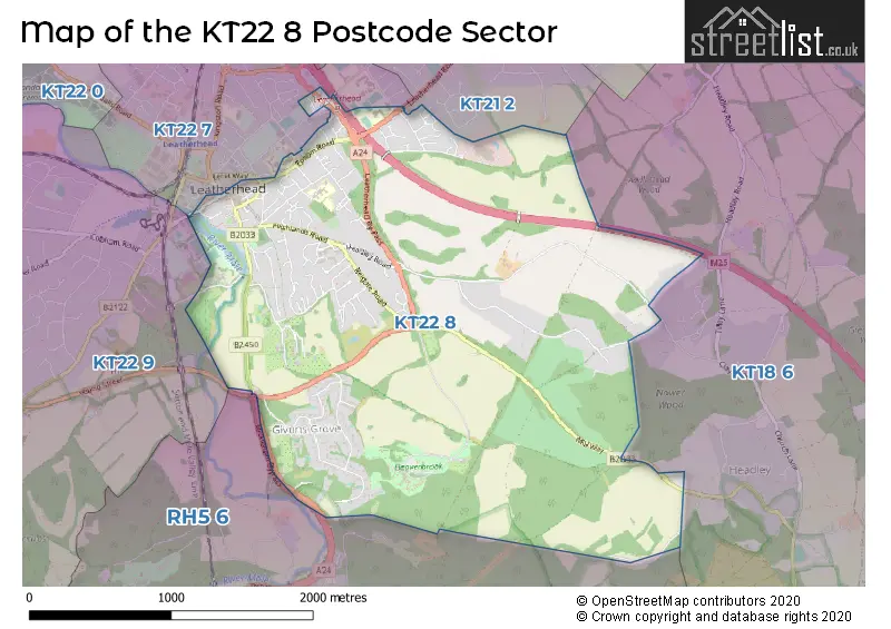
The KT22 8 Postcode shares a border with KT22 9 (FETCHAM), RH5 6 (Holmbury St. Mary, Abinger Hammer, Mickleham), KT22 7 (LEATHERHEAD, ASHTEAD), KT18 6 (EPSOM , HEADLEY , ASHTEAD ) and KT21 2 (ASHTEAD ).
Map of the KT22 8 Postcode Sector
Explore the KT22 8 postcode sector by using our interactive map.
The sector is within the post town of LEATHERHEAD.
KT22 8 is a postcode sector within the KT22 postcode district which is within the KT Kingston upon Thames postcode area.
The Royal Mail delivery office for the KT22 8 postal sector is the Leatherhead Delivery Office.
The area of the KT22 8 postcode sector is 3.14 square miles which is 8.14 square kilometres or 2,010.88 square acres.
The KT22 8 postcode sector is crossed by the M25 motorway.
Waterways within the KT22 8 postcode sector include the River Mole.
Your support helps keep this site running!
If you enjoy using this website, consider buying me a coffee to help cover hosting costs.


| K | T | 2 | 2 | - | 8 | X | X |
| K | T | 2 | 2 | Space | 8 | Letter | Letter |
Official List of Streets
LEATHERHEAD (89 Streets)
Unofficial Streets or Alternative Spellings
LEATHERHEAD
GARLANDS ROAD GRANGE ROAD LERET WAY LINDEN ROAD NORTH STREETASHTEAD,
LEATHERHEAD ROADHeadley
LANGLEY LANEFetcham
GUILDFORD ROADWeather Forecast for KT22 8
Weather Forecast for Leatherhead
| Time Period | Icon | Description | Temperature | Rain Probability | Wind |
|---|---|---|---|---|---|
| 15:00 to 18:00 | Overcast | 6.0°C (feels like 4.0°C) | 8.00% | S 9 mph | |
| 18:00 to 21:00 | Partly cloudy (night) | 4.0°C (feels like 2.0°C) | 2.00% | SSE 7 mph | |
| 21:00 to 00:00 | Partly cloudy (night) | 3.0°C (feels like 0.0°C) | 1.00% | SE 7 mph |
| Time Period | Icon | Description | Temperature | Rain Probability | Wind |
|---|---|---|---|---|---|
| 00:00 to 03:00 | Partly cloudy (night) | 2.0°C (feels like 0.0°C) | 1.00% | SSE 4 mph | |
| 03:00 to 06:00 | Clear night | 2.0°C (feels like 0.0°C) | 0.00% | SSE 4 mph | |
| 06:00 to 09:00 | Clear night | 1.0°C (feels like -2.0°C) | 0.00% | SSE 4 mph | |
| 09:00 to 12:00 | Sunny day | 2.0°C (feels like 0.0°C) | 0.00% | SSE 4 mph | |
| 12:00 to 15:00 | Sunny day | 6.0°C (feels like 4.0°C) | 0.00% | SSE 7 mph | |
| 15:00 to 18:00 | Sunny day | 6.0°C (feels like 5.0°C) | 0.00% | S 7 mph | |
| 18:00 to 21:00 | Clear night | 2.0°C (feels like 0.0°C) | 1.00% | S 4 mph | |
| 21:00 to 00:00 | Clear night | 1.0°C (feels like -1.0°C) | 1.00% | S 4 mph |
| Time Period | Icon | Description | Temperature | Rain Probability | Wind |
|---|---|---|---|---|---|
| 00:00 to 03:00 | Clear night | 1.0°C (feels like -2.0°C) | 2.00% | S 4 mph | |
| 03:00 to 06:00 | Cloudy | 0.0°C (feels like -2.0°C) | 6.00% | SSW 4 mph | |
| 06:00 to 09:00 | Cloudy | 1.0°C (feels like -1.0°C) | 6.00% | SSW 4 mph | |
| 09:00 to 12:00 | Cloudy | 3.0°C (feels like 0.0°C) | 7.00% | S 7 mph | |
| 12:00 to 15:00 | Cloudy | 6.0°C (feels like 4.0°C) | 5.00% | SSW 7 mph | |
| 15:00 to 18:00 | Sunny day | 7.0°C (feels like 5.0°C) | 2.00% | SSW 7 mph | |
| 18:00 to 21:00 | Partly cloudy (night) | 4.0°C (feels like 2.0°C) | 2.00% | S 7 mph | |
| 21:00 to 00:00 | Cloudy | 4.0°C (feels like 1.0°C) | 5.00% | S 7 mph |
| Time Period | Icon | Description | Temperature | Rain Probability | Wind |
|---|---|---|---|---|---|
| 00:00 to 03:00 | Partly cloudy (night) | 4.0°C (feels like 1.0°C) | 3.00% | S 9 mph | |
| 03:00 to 06:00 | Partly cloudy (night) | 4.0°C (feels like 1.0°C) | 3.00% | S 9 mph | |
| 06:00 to 09:00 | Cloudy | 4.0°C (feels like 1.0°C) | 6.00% | SSW 9 mph | |
| 09:00 to 12:00 | Cloudy | 6.0°C (feels like 3.0°C) | 5.00% | S 11 mph | |
| 12:00 to 15:00 | Cloudy | 8.0°C (feels like 5.0°C) | 6.00% | SSW 13 mph | |
| 15:00 to 18:00 | Overcast | 9.0°C (feels like 6.0°C) | 15.00% | SSW 11 mph | |
| 18:00 to 21:00 | Overcast | 8.0°C (feels like 5.0°C) | 22.00% | SSW 11 mph | |
| 21:00 to 00:00 | Light rain | 8.0°C (feels like 5.0°C) | 45.00% | SW 9 mph |
| Time Period | Icon | Description | Temperature | Rain Probability | Wind |
|---|---|---|---|---|---|
| 00:00 to 03:00 | Clear night | 6.0°C (feels like 4.0°C) | 7.00% | W 7 mph | |
| 03:00 to 06:00 | Clear night | 5.0°C (feels like 3.0°C) | 5.00% | WNW 7 mph | |
| 06:00 to 09:00 | Clear night | 3.0°C (feels like 1.0°C) | 2.00% | WNW 4 mph | |
| 09:00 to 12:00 | Partly cloudy (day) | 4.0°C (feels like 2.0°C) | 1.00% | NW 4 mph | |
| 12:00 to 15:00 | Cloudy | 7.0°C (feels like 5.0°C) | 4.00% | NNW 4 mph | |
| 15:00 to 18:00 | Cloudy | 8.0°C (feels like 6.0°C) | 5.00% | N 4 mph | |
| 18:00 to 21:00 | Cloudy | 5.0°C (feels like 3.0°C) | 5.00% | NNE 4 mph | |
| 21:00 to 00:00 | Cloudy | 4.0°C (feels like 2.0°C) | 5.00% | NNE 4 mph |
Schools and Places of Education Within the KT22 8 Postcode Sector
Woodlands School
Community special school
Fortyfoot Road, Leatherhead, Surrey, KT22 8RY
Head: Ms Sarah Smith
Ofsted Rating: Outstanding
Inspection: 2023-12-14 (415 days ago)
Website: Visit Woodlands School Website
Phone: 01372377922
Number of Pupils: 106
House Prices in the KT22 8 Postcode Sector
| Type of Property | 2018 Average | 2018 Sales | 2017 Average | 2017 Sales | 2016 Average | 2016 Sales | 2015 Average | 2015 Sales |
|---|---|---|---|---|---|---|---|---|
| Detached | £880,394 | 30 | £964,199 | 40 | £1,032,338 | 25 | £947,190 | 42 |
| Semi-Detached | £551,200 | 10 | £553,136 | 7 | £578,842 | 18 | £598,295 | 10 |
| Terraced | £409,000 | 10 | £445,733 | 15 | £426,906 | 8 | £400,507 | 23 |
| Flats | £318,797 | 32 | £318,542 | 32 | £297,561 | 48 | £268,542 | 49 |
Important Postcodes KT22 8 in the Postcode Sector
KT22 8AB is the postcode for Surrey and Borders Partnership NHS Foundation Trust, Tylney House
KT22 8DP is the postcode for The Mansion Library, 70 Church Street, and The Mansion, Church Street
KT22 8RY is the postcode for MAIN BUILDING, Woodlands Upper School, Fortyfoot Road, Woodlands Lower School, Fortyfoot Road, and Woodlands Upper School, Fortyfoot Road
KT22 8SD is the postcode for Leatherhead Hospital, Poplar Road, and NHS Property Services Ltd, Leatherhead Hospital
KT22 8SJ is the postcode for Leatherhead Clinic, Poplar Road
| The KT22 8 Sector is within these Local Authorities |
|
|---|---|
| The KT22 8 Sector is within these Counties |
|
| The KT22 8 Sector is within these Water Company Areas |
|