A wide range of spatial data has been analysed to present this overview of the KA9 1 Postcode sector. If you would like anything added, please contact us.
Given that each sector allows for 400 unique postcode combinations. Letters C, I, K, M, O and V are not allowed in the last two letters of a postcode. With 203 postcodes already in use, this leaves 197 units available.
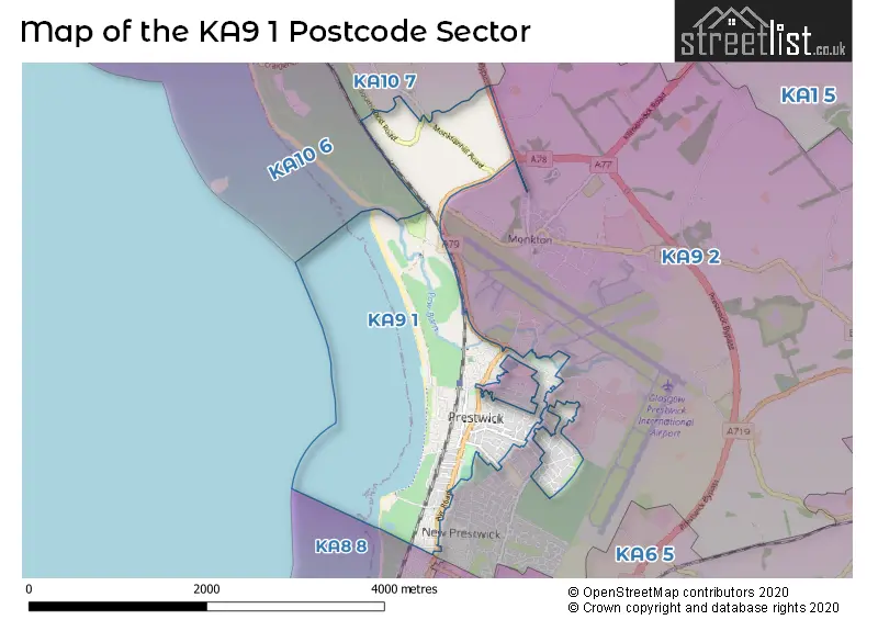
The largest settlements in the KA9 1 postal code are PRESTWICK and Monkton.
The KA9 1 Postcode shares a border with KA9 2 (PRESTWICK, Monkton, Glasgow Prestwick Intnl Airport), KA10 6 (TROON), KA10 7 (TROON, Loans) and KA8 8 (AYR).
Map of the KA9 1 Postcode Sector
Explore the KA9 1 postcode sector by using our interactive map.
The sector is within the post town of PRESTWICK.
KA9 1 is a postcode sector within the KA9 postcode district which is within the KA Kilmarnock postcode area.
The Royal Mail delivery office for the KA9 1 postal sector is the Prestwick Delivery Office.
The area of the KA9 1 postcode sector is 1.84 square miles which is 4.77 square kilometres or 1,178.38 square acres.
Your support helps keep this site running!
If you enjoy using this website, consider buying me a coffee to help cover hosting costs.


| K | A | 9 | - | 1 | X | X |
| K | A | 9 | Space | 1 | Letter | Letter |
Official List of Streets
PRESTWICK (129 Streets)
Unofficial Streets or Alternative Spellings
PRESTWICK
ADAMTON ROAD NORTH ADAMTON ROAD SOUTH ALVORD AVENUE BIGGART ROAD BOYDFIELD AVENUE CRANDLEYHILL ROAD FERNBANK LANGCROFT AVENUE MANSFIELD ROAD SAUNTERNE ROAD SHAW ROAD SHAWFARM GARDENS WATERLOO ROAD AYR AND KILMARNOCK CYCLE ROUTE BELLFIELD LANE BERELAND AVENUE BROOMEPARK AVENUE BRUCE LANE ESPLANADE MONKTONHEAD ROUNDABOUT NCN7 SHAWFARM COURT SMUGGLERS TRAIL ST NINIANS PARK LANE THE CRESCENT TROON BYPASSAYR,
EAST ROADAYR
OSWALD ROADMonkton
MAIN STREET MONKTONHILL ROADTROON
SOUTHWOOD ROADWeather Forecast for KA9 1
Weather Forecast for Prestwick
| Time Period | Icon | Description | Temperature | Rain Probability | Wind |
|---|---|---|---|---|---|
| 09:00 to 12:00 | Sunny day | 4.0°C (feels like 1.0°C) | 2.00% | NW 9 mph | |
| 12:00 to 15:00 | Sunny day | 6.0°C (feels like 3.0°C) | 0.00% | W 9 mph | |
| 15:00 to 18:00 | Partly cloudy (day) | 6.0°C (feels like 3.0°C) | 1.00% | W 9 mph | |
| 18:00 to 21:00 | Cloudy | 4.0°C (feels like 1.0°C) | 5.00% | SSW 9 mph | |
| 21:00 to 00:00 | Cloudy | 5.0°C (feels like 1.0°C) | 16.00% | S 11 mph |
| Time Period | Icon | Description | Temperature | Rain Probability | Wind |
|---|---|---|---|---|---|
| 00:00 to 03:00 | Heavy rain | 4.0°C (feels like 0.0°C) | 90.00% | S 16 mph | |
| 03:00 to 06:00 | Heavy rain | 5.0°C (feels like 2.0°C) | 81.00% | SSW 11 mph | |
| 06:00 to 09:00 | Partly cloudy (night) | 5.0°C (feels like 2.0°C) | 7.00% | WNW 11 mph | |
| 09:00 to 12:00 | Partly cloudy (day) | 5.0°C (feels like 2.0°C) | 4.00% | NNW 7 mph | |
| 12:00 to 15:00 | Cloudy | 7.0°C (feels like 5.0°C) | 6.00% | ENE 4 mph | |
| 15:00 to 18:00 | Cloudy | 7.0°C (feels like 6.0°C) | 6.00% | WSW 4 mph | |
| 18:00 to 21:00 | Cloudy | 4.0°C (feels like 3.0°C) | 5.00% | ESE 4 mph | |
| 21:00 to 00:00 | Cloudy | 3.0°C (feels like 1.0°C) | 6.00% | SE 4 mph |
| Time Period | Icon | Description | Temperature | Rain Probability | Wind |
|---|---|---|---|---|---|
| 00:00 to 03:00 | Cloudy | 3.0°C (feels like 1.0°C) | 7.00% | SE 7 mph | |
| 03:00 to 06:00 | Cloudy | 4.0°C (feels like 1.0°C) | 6.00% | SE 9 mph | |
| 06:00 to 09:00 | Cloudy | 5.0°C (feels like 1.0°C) | 7.00% | SSE 11 mph | |
| 09:00 to 12:00 | Cloudy | 5.0°C (feels like 1.0°C) | 6.00% | SSE 13 mph | |
| 12:00 to 15:00 | Overcast | 7.0°C (feels like 3.0°C) | 9.00% | SSE 16 mph | |
| 15:00 to 18:00 | Overcast | 7.0°C (feels like 3.0°C) | 16.00% | SSE 18 mph | |
| 18:00 to 21:00 | Overcast | 7.0°C (feels like 3.0°C) | 16.00% | SSE 18 mph | |
| 21:00 to 00:00 | Overcast | 7.0°C (feels like 3.0°C) | 21.00% | S 20 mph |
| Time Period | Icon | Description | Temperature | Rain Probability | Wind |
|---|---|---|---|---|---|
| 00:00 to 03:00 | Overcast | 7.0°C (feels like 3.0°C) | 31.00% | S 18 mph | |
| 03:00 to 06:00 | Heavy rain | 7.0°C (feels like 3.0°C) | 77.00% | SSW 16 mph | |
| 06:00 to 09:00 | Heavy rain | 6.0°C (feels like 3.0°C) | 77.00% | SW 13 mph | |
| 09:00 to 12:00 | Light rain | 6.0°C (feels like 3.0°C) | 47.00% | WSW 13 mph | |
| 12:00 to 15:00 | Cloudy | 7.0°C (feels like 4.0°C) | 12.00% | WSW 11 mph | |
| 15:00 to 18:00 | Cloudy | 7.0°C (feels like 4.0°C) | 12.00% | W 11 mph | |
| 18:00 to 21:00 | Cloudy | 6.0°C (feels like 3.0°C) | 8.00% | SW 9 mph | |
| 21:00 to 00:00 | Cloudy | 5.0°C (feels like 2.0°C) | 9.00% | S 9 mph |
| The KA9 1 Sector is within these Local Authorities | |
|---|---|
| The KA9 1 Sector is within these Counties | |
| The KA9 1 Sector is within these Water Company Areas |