A wide range of spatial data has been analysed to present this overview of the KA30 9 Postcode sector. If you would like anything added, please contact us.
Given that each sector allows for 400 unique postcode combinations. Letters C, I, K, M, O and V are not allowed in the last two letters of a postcode. With 144 postcodes already in use, this leaves 256 units available.
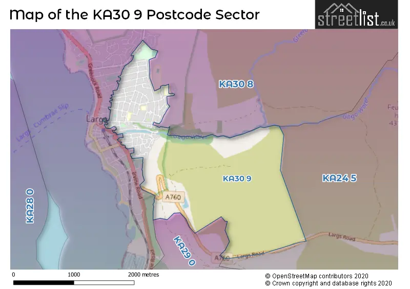
The KA30 9 postal code covers the settlement of LARGS.
The KA30 9 Postcode shares a border with KA30 8 (LARGS), KA24 5 (DALRY) and KA29 0 (Fairlie).
Map of the KA30 9 Postcode Sector
Explore the KA30 9 postcode sector by using our interactive map.
The sector is within the post town of LARGS.
KA30 9 is a postcode sector within the KA30 postcode district which is within the KA Kilmarnock postcode area.
The Royal Mail delivery office for the KA30 9 postal sector is the Largs Delivery Office.
The area of the KA30 9 postcode sector is 1.99 square miles which is 5.14 square kilometres or 1,270.50 square acres.
Your support helps keep this site running!
If you enjoy using this website, consider buying me a coffee to help cover hosting costs.


| K | A | 3 | 0 | - | 9 | X | X |
| K | A | 3 | 0 | Space | 9 | Letter | Letter |
Official List of Streets
LARGS (78 Streets)
Unofficial Streets or Alternative Spellings
KILBIRNIE
LARGS ROADLARGS
AITKEN STREET BOYD STREET BRISBANE GLEN ROAD BRISBANE ROAD EAST CASTLE AVENUE GLEN AVENUE IRVINE ROAD LADE STREET MAIN STREET MEADOWBANK ROAD TOWNHEAD CLOSE TRIGONI COURT TRON PLACE AMY PLACE BELLMANS CLOSE CUNNINGHAM DRIVE HAYLIE BRAE LINDON COURT MT STUART ROAD SCOTLAW DRIVE WATERSIDE COURTWeather Forecast for KA30 9
Weather Forecast for Largs
| Time Period | Icon | Description | Temperature | Rain Probability | Wind |
|---|---|---|---|---|---|
| 03:00 to 06:00 | Cloudy | 6.0°C (feels like 4.0°C) | 8.00% | S 7 mph | |
| 06:00 to 09:00 | Cloudy | 6.0°C (feels like 4.0°C) | 12.00% | S 4 mph | |
| 09:00 to 12:00 | Cloudy | 6.0°C (feels like 4.0°C) | 15.00% | S 7 mph | |
| 12:00 to 15:00 | Cloudy | 7.0°C (feels like 5.0°C) | 17.00% | S 7 mph | |
| 15:00 to 18:00 | Cloudy | 7.0°C (feels like 5.0°C) | 16.00% | S 7 mph | |
| 18:00 to 21:00 | Cloudy | 6.0°C (feels like 4.0°C) | 13.00% | S 7 mph | |
| 21:00 to 00:00 | Cloudy | 6.0°C (feels like 3.0°C) | 13.00% | S 7 mph |
| Time Period | Icon | Description | Temperature | Rain Probability | Wind |
|---|---|---|---|---|---|
| 00:00 to 03:00 | Cloudy | 5.0°C (feels like 3.0°C) | 13.00% | SSE 7 mph | |
| 03:00 to 06:00 | Cloudy | 4.0°C (feels like 3.0°C) | 16.00% | SE 4 mph | |
| 06:00 to 09:00 | Mist | 4.0°C (feels like 2.0°C) | 20.00% | E 4 mph | |
| 09:00 to 12:00 | Overcast | 4.0°C (feels like 2.0°C) | 14.00% | ESE 4 mph | |
| 12:00 to 15:00 | Overcast | 5.0°C (feels like 3.0°C) | 15.00% | E 4 mph | |
| 15:00 to 18:00 | Overcast | 5.0°C (feels like 4.0°C) | 14.00% | ESE 4 mph | |
| 18:00 to 21:00 | Cloudy | 4.0°C (feels like 2.0°C) | 9.00% | ESE 4 mph | |
| 21:00 to 00:00 | Cloudy | 4.0°C (feels like 2.0°C) | 13.00% | ESE 4 mph |
| Time Period | Icon | Description | Temperature | Rain Probability | Wind |
|---|---|---|---|---|---|
| 00:00 to 03:00 | Overcast | 4.0°C (feels like 2.0°C) | 17.00% | SE 7 mph | |
| 03:00 to 06:00 | Overcast | 4.0°C (feels like 2.0°C) | 17.00% | ESE 4 mph | |
| 06:00 to 09:00 | Cloudy | 3.0°C (feels like 1.0°C) | 17.00% | ESE 4 mph | |
| 09:00 to 12:00 | Overcast | 4.0°C (feels like 2.0°C) | 22.00% | NNW 7 mph | |
| 12:00 to 15:00 | Cloudy | 5.0°C (feels like 3.0°C) | 15.00% | W 7 mph | |
| 15:00 to 18:00 | Cloudy | 5.0°C (feels like 3.0°C) | 15.00% | W 7 mph | |
| 18:00 to 21:00 | Cloudy | 5.0°C (feels like 2.0°C) | 13.00% | S 7 mph | |
| 21:00 to 00:00 | Cloudy | 5.0°C (feels like 2.0°C) | 12.00% | SSE 7 mph |
| The KA30 9 Sector is within these Local Authorities | |
|---|---|
| The KA30 9 Sector is within these Counties | |
| The KA30 9 Sector is within these Water Company Areas |