A wide range of spatial data has been analysed to present this overview of the KA27 8 Postcode sector. If you would like anything added, please contact us.
Given that each sector allows for 400 unique postcode combinations. Letters C, I, K, M, O and V are not allowed in the last two letters of a postcode. With 199 postcodes already in use, this leaves 201 units available.
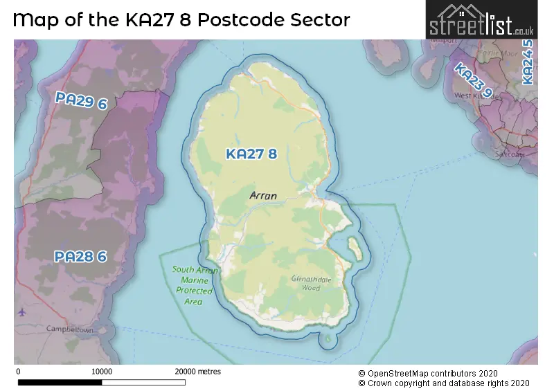
The largest settlement in the KA27 8 postal code is Lamlash followed by Brodick, and Whiting Bay.
Map of the KA27 8 Postcode Sector
Explore the KA27 8 postcode sector by using our interactive map.
The sector is within the post town of ISLE OF ARRAN.
KA27 8 is a postcode sector within the KA27 postcode district which is within the KA Kilmarnock postcode area.
The Royal Mail delivery office for the KA27 8 postal sector is the Brodick Delivery Office.
The area of the KA27 8 postcode sector is 166.18 square miles which is 430.39 square kilometres or 106,351.97 square acres.
Your support helps keep this site running!
If you enjoy using this website, consider buying me a coffee to help cover hosting costs.


| K | A | 2 | 7 | - | 8 | X | X |
| K | A | 2 | 7 | Space | 8 | Letter | Letter |
Official List of Streets
Brodick (30 Streets)
Lamlash (21 Streets)
Whiting Bay (6 Streets)
Lochranza (2 Streets)
Corrie (3 Streets)
Sliddery (2 Streets)
Blackwaterfoot (2 Streets)
Shiskine (2 Streets)
Pirnmill (1 Streets)
Kilmory (1 Streets)
Unofficial Streets or Alternative Spellings
Weather Forecast for KA27 8
Weather Forecast for Beinn Nuis
| Time Period | Icon | Description | Temperature | Rain Probability | Wind |
|---|---|---|---|---|---|
| 18:00 to 21:00 | Heavy rain | 3.0°C (feels like -1.0°C) | 89.00% | SSE 18 mph | |
| 21:00 to 00:00 | Heavy rain | 5.0°C (feels like -2.0°C) | 91.00% | SSW 36 mph |
| Time Period | Icon | Description | Temperature | Rain Probability | Wind |
|---|---|---|---|---|---|
| 00:00 to 03:00 | Heavy rain | 4.0°C (feels like -4.0°C) | 85.00% | SSW 40 mph | |
| 03:00 to 06:00 | Heavy rain | 4.0°C (feels like -4.0°C) | 91.00% | SSW 47 mph | |
| 06:00 to 09:00 | Heavy rain | 4.0°C (feels like -4.0°C) | 94.00% | SSW 49 mph | |
| 09:00 to 12:00 | Light rain shower (day) | 5.0°C (feels like -3.0°C) | 64.00% | SW 47 mph | |
| 12:00 to 15:00 | Light rain shower (day) | 4.0°C (feels like -4.0°C) | 37.00% | SW 45 mph | |
| 15:00 to 18:00 | Light rain | 3.0°C (feels like -6.0°C) | 49.00% | WSW 49 mph | |
| 18:00 to 21:00 | Overcast | 2.0°C (feels like -7.0°C) | 16.00% | WSW 49 mph | |
| 21:00 to 00:00 | Overcast | 2.0°C (feels like -7.0°C) | 20.00% | W 45 mph |
| Time Period | Icon | Description | Temperature | Rain Probability | Wind |
|---|---|---|---|---|---|
| 00:00 to 03:00 | Light snow | 1.0°C (feels like -8.0°C) | 59.00% | WNW 38 mph | |
| 03:00 to 06:00 | Light snow | -1.0°C (feels like -8.0°C) | 54.00% | NW 27 mph | |
| 06:00 to 09:00 | Cloudy | -1.0°C (feels like -7.0°C) | 18.00% | NNW 16 mph | |
| 09:00 to 12:00 | Light snow | -2.0°C (feels like -8.0°C) | 53.00% | NNE 18 mph | |
| 12:00 to 15:00 | Light snow | -2.0°C (feels like -9.0°C) | 61.00% | NNE 22 mph | |
| 15:00 to 18:00 | Light snow shower (day) | -2.0°C (feels like -10.0°C) | 49.00% | NNE 22 mph | |
| 18:00 to 21:00 | Light snow shower (night) | -3.0°C (feels like -11.0°C) | 49.00% | N 22 mph | |
| 21:00 to 00:00 | Light snow shower (night) | -4.0°C (feels like -12.0°C) | 48.00% | NNW 20 mph |
| Time Period | Icon | Description | Temperature | Rain Probability | Wind |
|---|---|---|---|---|---|
| 00:00 to 03:00 | Light snow shower (night) | -4.0°C (feels like -12.0°C) | 50.00% | NNW 20 mph | |
| 03:00 to 06:00 | Light snow shower (night) | -4.0°C (feels like -12.0°C) | 48.00% | NNW 20 mph | |
| 06:00 to 09:00 | Light snow shower (night) | -5.0°C (feels like -12.0°C) | 48.00% | NNW 18 mph | |
| 09:00 to 12:00 | Light snow shower (day) | -5.0°C (feels like -12.0°C) | 48.00% | NNW 18 mph | |
| 12:00 to 15:00 | Light snow shower (day) | -3.0°C (feels like -10.0°C) | 48.00% | NNW 16 mph | |
| 15:00 to 18:00 | Light snow shower (day) | -3.0°C (feels like -10.0°C) | 47.00% | NNW 16 mph | |
| 18:00 to 21:00 | Light snow shower (night) | -5.0°C (feels like -12.0°C) | 44.00% | NNW 13 mph | |
| 21:00 to 00:00 | Light snow shower (night) | -5.0°C (feels like -12.0°C) | 40.00% | NW 13 mph |
| Time Period | Icon | Description | Temperature | Rain Probability | Wind |
|---|---|---|---|---|---|
| 00:00 to 03:00 | Light snow shower (night) | -5.0°C (feels like -12.0°C) | 40.00% | WNW 13 mph | |
| 03:00 to 06:00 | Light snow shower (night) | -4.0°C (feels like -11.0°C) | 45.00% | W 16 mph | |
| 06:00 to 09:00 | Light snow shower (night) | -3.0°C (feels like -11.0°C) | 47.00% | W 20 mph | |
| 09:00 to 12:00 | Light snow shower (day) | -3.0°C (feels like -10.0°C) | 48.00% | W 22 mph | |
| 12:00 to 15:00 | Heavy snow shower (day) | -1.0°C (feels like -9.0°C) | 63.00% | W 22 mph | |
| 15:00 to 18:00 | Heavy snow shower (day) | -1.0°C (feels like -8.0°C) | 65.00% | WNW 22 mph | |
| 18:00 to 21:00 | Heavy snow shower (night) | -2.0°C (feels like -10.0°C) | 62.00% | WNW 22 mph | |
| 21:00 to 00:00 | Heavy snow shower (night) | -3.0°C (feels like -10.0°C) | 61.00% | WNW 22 mph |
| The KA27 8 Sector is within these Local Authorities | |
|---|---|
| The KA27 8 Sector is within these Counties | |
| The KA27 8 Sector is within these Water Company Areas |