A wide range of spatial data has been analysed to present this overview of the KA24 5 Postcode sector. If you would like anything added, please contact us.
Given that each sector allows for 400 unique postcode combinations. Letters C, I, K, M, O and V are not allowed in the last two letters of a postcode. With 108 postcodes already in use, this leaves 292 units available.
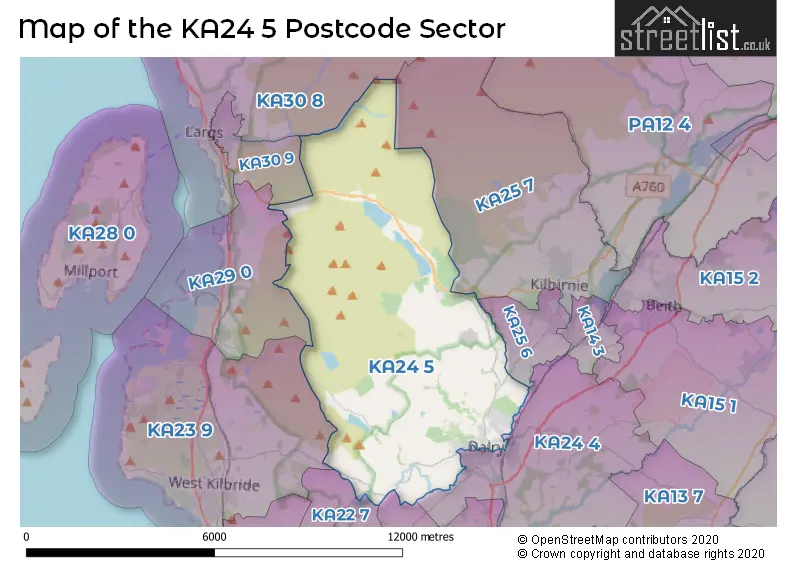
The KA24 5 postal code covers the settlement of DALRY.
The KA24 5 Postcode shares a border with KA21 6 (SALTCOATS), KA30 8 (LARGS), KA23 9 (WEST KILBRIDE, Seamill, Portencross), KA25 6 (KILBIRNIE), KA22 7 (ARDROSSAN), KA24 4 (DALRY), KA25 7 (KILBIRNIE), KA29 0 (Fairlie) and KA30 9 (LARGS).
Map of the KA24 5 Postcode Sector
Explore the KA24 5 postcode sector by using our interactive map.
The sector is within the post town of DALRY.
KA24 5 is a postcode sector within the KA24 postcode district which is within the KA Kilmarnock postcode area.
The Royal Mail delivery office for the KA24 5 postal sector is the Dalry (ka) Delivery Office.
The area of the KA24 5 postcode sector is 24.08 square miles which is 62.37 square kilometres or 15,412.19 square acres.
Your support helps keep this site running!
If you enjoy using this website, consider buying me a coffee to help cover hosting costs.


| K | A | 2 | 4 | - | 5 | X | X |
| K | A | 2 | 4 | Space | 5 | Letter | Letter |
Official List of Streets
DALRY (48 Streets)
Unofficial Streets or Alternative Spellings
DALRY
AITKEN STREET BEITH ROAD BRIDGEND GARNOCK STREET KITTYSHAW ROAD TOWNEND STREET VENNEL STREET BAIDLANDHILL CUNNINGHAM BAIDLAND DALRY ROAD FAIRLIE MOOR ROAD GREEN BANK KELBURN HIGH ESTATE ROAD LINTSEEDRIDGE ST MARGARET AVENUE ST MARGARETS AVENUE THIRDPART WINDYEDGEWEST KILBRIDE
DALRY ROADKILBIRNIE
LARGS ROADWeather Forecast for KA24 5
Weather Forecast for Fairlie
| Time Period | Icon | Description | Temperature | Rain Probability | Wind |
|---|---|---|---|---|---|
| 12:00 to 15:00 | Cloudy | 7.0°C (feels like 3.0°C) | 8.00% | SSE 18 mph | |
| 15:00 to 18:00 | Overcast | 7.0°C (feels like 3.0°C) | 14.00% | SSE 20 mph | |
| 18:00 to 21:00 | Overcast | 7.0°C (feels like 2.0°C) | 17.00% | SSE 20 mph | |
| 21:00 to 00:00 | Overcast | 7.0°C (feels like 3.0°C) | 17.00% | SSE 20 mph |
| Time Period | Icon | Description | Temperature | Rain Probability | Wind |
|---|---|---|---|---|---|
| 00:00 to 03:00 | Overcast | 7.0°C (feels like 2.0°C) | 21.00% | SSE 20 mph | |
| 03:00 to 06:00 | Light rain | 7.0°C (feels like 2.0°C) | 54.00% | SSE 18 mph | |
| 06:00 to 09:00 | Light rain | 7.0°C (feels like 2.0°C) | 59.00% | S 20 mph | |
| 09:00 to 12:00 | Light rain | 7.0°C (feels like 3.0°C) | 55.00% | S 18 mph | |
| 12:00 to 15:00 | Light rain | 7.0°C (feels like 4.0°C) | 56.00% | SSW 11 mph | |
| 15:00 to 18:00 | Cloudy | 8.0°C (feels like 6.0°C) | 11.00% | SW 9 mph | |
| 18:00 to 21:00 | Cloudy | 6.0°C (feels like 3.0°C) | 5.00% | S 9 mph | |
| 21:00 to 00:00 | Cloudy | 7.0°C (feels like 3.0°C) | 5.00% | S 13 mph |
| Time Period | Icon | Description | Temperature | Rain Probability | Wind |
|---|---|---|---|---|---|
| 00:00 to 03:00 | Cloudy | 7.0°C (feels like 2.0°C) | 9.00% | S 18 mph | |
| 03:00 to 06:00 | Cloudy | 7.0°C (feels like 3.0°C) | 9.00% | S 18 mph | |
| 06:00 to 09:00 | Cloudy | 7.0°C (feels like 3.0°C) | 13.00% | S 18 mph | |
| 09:00 to 12:00 | Cloudy | 8.0°C (feels like 4.0°C) | 15.00% | S 20 mph | |
| 12:00 to 15:00 | Cloudy | 9.0°C (feels like 5.0°C) | 21.00% | S 22 mph | |
| 15:00 to 18:00 | Overcast | 9.0°C (feels like 5.0°C) | 25.00% | S 22 mph | |
| 18:00 to 21:00 | Light rain | 9.0°C (feels like 5.0°C) | 59.00% | S 22 mph | |
| 21:00 to 00:00 | Light rain | 9.0°C (feels like 5.0°C) | 70.00% | S 22 mph |
| Time Period | Icon | Description | Temperature | Rain Probability | Wind |
|---|---|---|---|---|---|
| 00:00 to 03:00 | Heavy rain | 9.0°C (feels like 5.0°C) | 90.00% | S 22 mph | |
| 03:00 to 06:00 | Heavy rain | 9.0°C (feels like 5.0°C) | 90.00% | SSW 20 mph | |
| 06:00 to 09:00 | Heavy rain | 9.0°C (feels like 5.0°C) | 79.00% | SSW 20 mph | |
| 09:00 to 12:00 | Light rain | 8.0°C (feels like 5.0°C) | 48.00% | SW 16 mph | |
| 12:00 to 15:00 | Light rain shower (day) | 8.0°C (feels like 5.0°C) | 32.00% | SW 18 mph | |
| 15:00 to 18:00 | Light rain shower (day) | 8.0°C (feels like 4.0°C) | 34.00% | SW 18 mph | |
| 18:00 to 21:00 | Light rain shower (night) | 6.0°C (feels like 3.0°C) | 29.00% | WSW 16 mph | |
| 21:00 to 00:00 | Cloudy | 6.0°C (feels like 2.0°C) | 10.00% | WSW 18 mph |
| Time Period | Icon | Description | Temperature | Rain Probability | Wind |
|---|---|---|---|---|---|
| 00:00 to 03:00 | Partly cloudy (night) | 5.0°C (feels like 1.0°C) | 6.00% | WSW 18 mph | |
| 03:00 to 06:00 | Partly cloudy (night) | 5.0°C (feels like 1.0°C) | 3.00% | WSW 16 mph | |
| 06:00 to 09:00 | Partly cloudy (night) | 5.0°C (feels like 1.0°C) | 2.00% | WSW 16 mph | |
| 09:00 to 12:00 | Cloudy | 5.0°C (feels like 1.0°C) | 4.00% | WSW 13 mph | |
| 12:00 to 15:00 | Partly cloudy (day) | 7.0°C (feels like 3.0°C) | 3.00% | SW 16 mph | |
| 15:00 to 18:00 | Sunny day | 7.0°C (feels like 4.0°C) | 4.00% | SW 13 mph | |
| 18:00 to 21:00 | Clear night | 6.0°C (feels like 3.0°C) | 2.00% | SSW 11 mph | |
| 21:00 to 00:00 | Clear night | 6.0°C (feels like 2.0°C) | 1.00% | SSW 11 mph |
| The KA24 5 Sector is within these Local Authorities | |
|---|---|
| The KA24 5 Sector is within these Counties | |
| The KA24 5 Sector is within these Water Company Areas |