A wide range of spatial data has been analysed to present this overview of the KA19 8 Postcode sector. If you would like anything added, please contact us.
Given that each sector allows for 400 unique postcode combinations. Letters C, I, K, M, O and V are not allowed in the last two letters of a postcode. With 129 postcodes already in use, this leaves 271 units available.
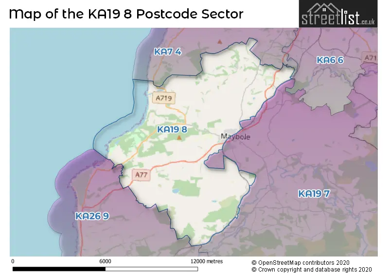
The largest settlement in the KA19 8 postal code is MAYBOLE followed by Kirkoswald, and Minishant.
The KA19 8 Postcode shares a border with KA7 4 (AYR, Dunure, Doonfoot), KA6 6 (Coylton, Dalrymple, AYR), KA19 7 (MAYBOLE, Crosshill, Straiton) and KA26 9 (GIRVAN, Dailly, Maidens).
Map of the KA19 8 Postcode Sector
Explore the KA19 8 postcode sector by using our interactive map.
The sector is within the post town of MAYBOLE.
KA19 8 is a postcode sector within the KA19 postcode district which is within the KA Kilmarnock postcode area.
The Royal Mail delivery office for the KA19 8 postal sector is the Maybole Delivery Office and Girvan Delivery Office.
The area of the KA19 8 postcode sector is 30.60 square miles which is 79.25 square kilometres or 19,582.54 square acres.
Your support helps keep this site running!
If you enjoy using this website, consider buying me a coffee to help cover hosting costs.


| K | A | 1 | 9 | - | 8 | X | X |
| K | A | 1 | 9 | Space | 8 | Letter | Letter |
Official List of Streets
MAYBOLE (41 Streets)
Kirkoswald (8 Streets)
Unofficial Streets or Alternative Spellings
Maidens
ARDLOCHAN ROAD KIRKOSWALD ROADWeather Forecast for KA19 8
Weather Forecast for Croy (Beach)
| The KA19 8 Sector is within these Local Authorities | |
|---|---|
| The KA19 8 Sector is within these Counties | |
| The KA19 8 Sector is within these Water Company Areas |