A wide range of spatial data has been analysed to present this overview of the KA14 3 Postcode sector. If you would like anything added, please contact us.
Given that each sector allows for 400 unique postcode combinations. Letters C, I, K, M, O and V are not allowed in the last two letters of a postcode. With 34 postcodes already in use, this leaves 366 units available.
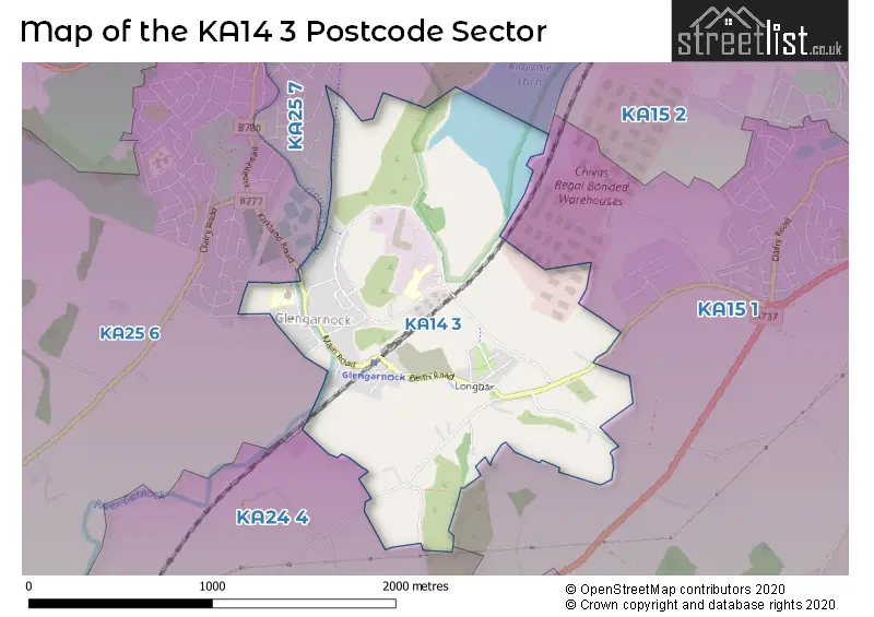
The KA14 3 postal code covers the settlement of Glengarnock.
The KA14 3 Postcode shares a border with KA25 6 (KILBIRNIE), KA15 1 (BEITH, Barrmill, Burnhouse), KA24 4 (DALRY) and KA25 7 (KILBIRNIE).
Map of the KA14 3 Postcode Sector
Explore the KA14 3 postcode sector by using our interactive map.
The sector is within the post town of BEITH.
KA14 3 is a postcode sector within the KA14 postcode district which is within the KA Kilmarnock postcode area.
The Royal Mail delivery office for the KA14 3 postal sector is the Beith Delivery Office.
The area of the KA14 3 postcode sector is 1.16 square miles which is 3.02 square kilometres or 745.08 square acres.
Your support helps keep this site running!
If you enjoy using this website, consider buying me a coffee to help cover hosting costs.


| K | A | 1 | 4 | - | 3 | X | X |
| K | A | 1 | 4 | Space | 3 | Letter | Letter |
Official List of Streets
Glengarnock (23 Streets)
Unofficial Streets or Alternative Spellings
Weather Forecast for KA14 3
Weather Forecast for Kilbirnie
| Time Period | Icon | Description | Temperature | Rain Probability | Wind |
|---|---|---|---|---|---|
| 03:00 to 06:00 | Overcast | 5.0°C (feels like 4.0°C) | 13.00% | S 4 mph | |
| 06:00 to 09:00 | Cloudy | 5.0°C (feels like 4.0°C) | 11.00% | S 4 mph | |
| 09:00 to 12:00 | Cloudy | 5.0°C (feels like 3.0°C) | 14.00% | S 4 mph | |
| 12:00 to 15:00 | Cloudy | 6.0°C (feels like 4.0°C) | 16.00% | S 7 mph | |
| 15:00 to 18:00 | Cloudy | 6.0°C (feels like 4.0°C) | 16.00% | S 7 mph | |
| 18:00 to 21:00 | Cloudy | 5.0°C (feels like 3.0°C) | 15.00% | S 4 mph | |
| 21:00 to 00:00 | Cloudy | 5.0°C (feels like 3.0°C) | 15.00% | S 4 mph |
| Time Period | Icon | Description | Temperature | Rain Probability | Wind |
|---|---|---|---|---|---|
| 00:00 to 03:00 | Cloudy | 4.0°C (feels like 3.0°C) | 14.00% | SSE 4 mph | |
| 03:00 to 06:00 | Cloudy | 3.0°C (feels like 2.0°C) | 14.00% | SE 4 mph | |
| 06:00 to 09:00 | Mist | 3.0°C (feels like 2.0°C) | 19.00% | E 2 mph | |
| 09:00 to 12:00 | Overcast | 3.0°C (feels like 1.0°C) | 12.00% | E 4 mph | |
| 12:00 to 15:00 | Overcast | 5.0°C (feels like 3.0°C) | 13.00% | E 4 mph | |
| 15:00 to 18:00 | Overcast | 5.0°C (feels like 3.0°C) | 13.00% | E 4 mph | |
| 18:00 to 21:00 | Cloudy | 4.0°C (feels like 2.0°C) | 9.00% | E 4 mph | |
| 21:00 to 00:00 | Cloudy | 3.0°C (feels like 1.0°C) | 11.00% | E 4 mph |
| Time Period | Icon | Description | Temperature | Rain Probability | Wind |
|---|---|---|---|---|---|
| 00:00 to 03:00 | Overcast | 3.0°C (feels like 1.0°C) | 14.00% | ESE 4 mph | |
| 03:00 to 06:00 | Overcast | 3.0°C (feels like 1.0°C) | 17.00% | E 4 mph | |
| 06:00 to 09:00 | Overcast | 3.0°C (feels like 1.0°C) | 19.00% | SE 4 mph | |
| 09:00 to 12:00 | Overcast | 3.0°C (feels like 1.0°C) | 21.00% | SSE 4 mph | |
| 12:00 to 15:00 | Overcast | 4.0°C (feels like 2.0°C) | 19.00% | SSE 7 mph | |
| 15:00 to 18:00 | Overcast | 5.0°C (feels like 3.0°C) | 18.00% | S 7 mph | |
| 18:00 to 21:00 | Cloudy | 3.0°C (feels like 1.0°C) | 13.00% | SSE 4 mph | |
| 21:00 to 00:00 | Cloudy | 3.0°C (feels like 1.0°C) | 11.00% | SSE 4 mph |
| The KA14 3 Sector is within these Local Authorities | |
|---|---|
| The KA14 3 Sector is within these Counties | |
| The KA14 3 Sector is within these Water Company Areas |