A wide range of spatial data has been analysed to present this overview. If you would like anything added, please contact us.
This section of the site is all about the IV Postcode area, also known as the Inverness Postal Area. Explore links to the next level to learn more about specific postcode districts such as IV1.
Your support helps keep this site running!
If you enjoy using this website, consider buying me a coffee to help cover hosting costs.
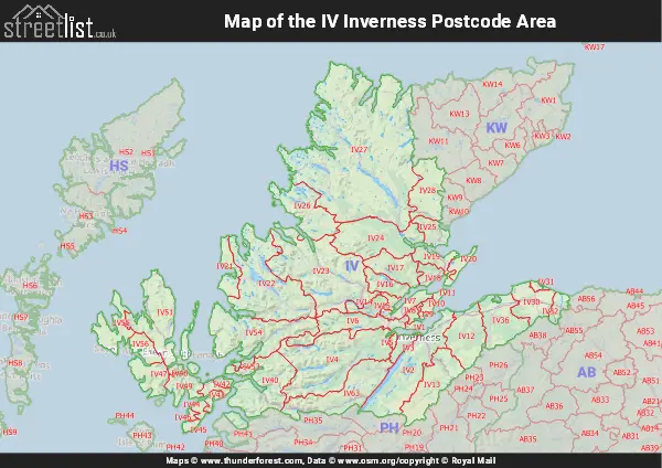
Map of the IV Inverness Postcode Area
Explore the postcode area by using our interactive map.
Quick Facts about the IV Postcode
| Width from East to West | 140.47 mi |
| Height from North to South | 109.40 mi |
| Area of IV | 829.14 mi² |
| Maximum Width | 140.66 mi |
| Perimeter of Postcode Area | 1,600.14 mi |
| Number of Postcode Districts | 50 |
| Number of Postcode Sectors | 71 |
| Number of Post Towns | 31 |
| Number of Postcodes | 7,392 |
The IV postcode area represents a group of 49 postal districts in the Inverness area of the United Kingdom. The area code stands for the letters i and v in InVerness. The area has a population of 228,244 and covers an area of 16,050,928 hectares. Fun fact: 0.35% of the population of Great Britain lives in this area.
The postcode area falls within the following counties: Ross and Cromarty (33.50%), Inverness (30.16%), Moray (25.45%), Nairn (5.78%), Sutherland (5.08%), Banffshire (0.02%).
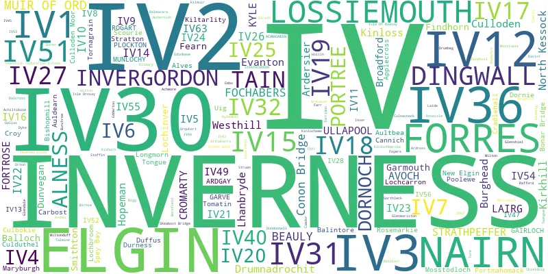
Post Towns and Postcode Districts
Where is the IV Postcode Area?
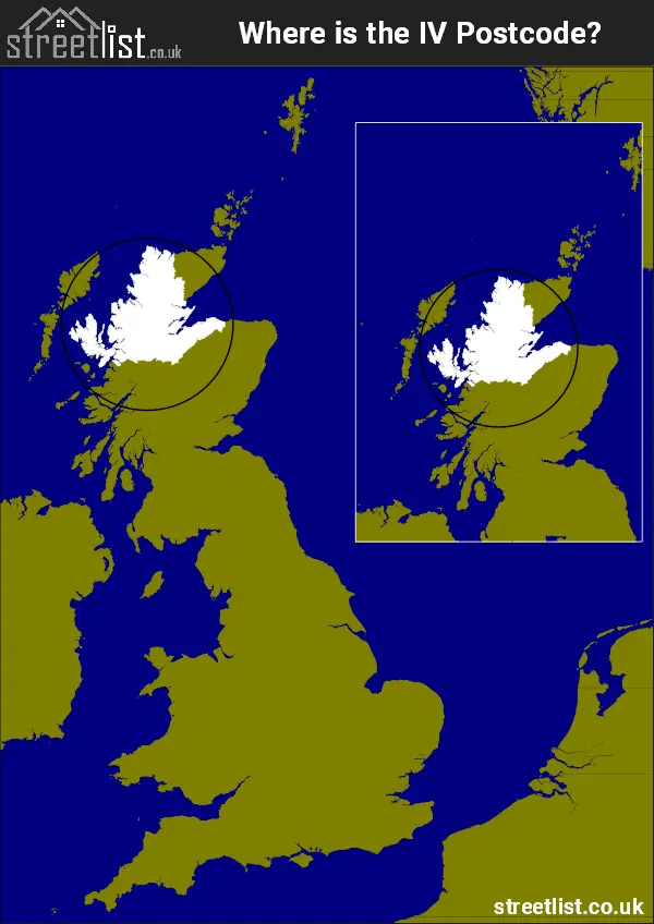
The IV Inverness Postcode is in Scotland.. The postal area borders the following neighbouring postal areas: PH - Perth, KW - Kirkwall and AB - Aberdeen, It also borders The North Atlantic Ocean, The Moray Firth, The Minch and Sea of the Hebredes.


How built up is the Postcode Area?
I've calculated the total area covered by building footprints within the postcode area.
By analyzing this against the total area, I've determined the percentage of the area that's developed, this will give you an idea of how urban or rural the postcode region is.
The higher the percentage the more urban the area is. For example the least urban district is IV23 and the most urban is IV27.
| Postcode District | Total Area (m²) | Footprint Area (m²) | Built Percentage % |
|---|---|---|---|
| IV23 | 1,172,441,789 | 135,761 | 0.01% |
| IV22 | 997,416,785 | 229,290 | 0.02% |
| IV28 | 375,177,286 | 92,154 | 0.02% |
| IV13 | 453,449,662 | 129,741 | 0.03% |
| IV24 | 602,382,845 | 207,133 | 0.03% |
| IV56 | 137,891,637 | 45,514 | 0.03% |
| IV54 | 725,989,953 | 200,011 | 0.03% |
| IV26 | 454,034,995 | 202,801 | 0.04% |
| IV40 | 737,962,204 | 297,949 | 0.04% |
| IV47 | 228,375,986 | 92,388 | 0.04% |
| IV48 | 29,066,806 | 11,702 | 0.04% |
| IV4 | 1,051,742,367 | 518,387 | 0.05% |
| IV63 | 593,318,088 | 332,510 | 0.06% |
| IV46 | 23,279,727 | 12,857 | 0.06% |
| IV53 | 25,717,642 | 15,636 | 0.06% |
| IV43 | 48,383,553 | 33,484 | 0.07% |
| IV49 | 200,509,003 | 139,047 | 0.07% |
| IV55 | 257,279,524 | 182,180 | 0.07% |
| IV42 | 58,780,695 | 45,952 | 0.08% |
| IV21 | 167,886,847 | 150,470 | 0.09% |
| IV44 | 47,265,537 | 44,117 | 0.09% |
| IV45 | 38,452,406 | 35,578 | 0.09% |
| IV51 | 557,744,059 | 544,566 | 0.10% |
| IV41 | 38,676,894 | 43,772 | 0.11% |
| IV16 | 161,936,664 | 200,329 | 0.12% |
| IV6 | 382,066,606 | 529,652 | 0.14% |
| IV17 | 270,681,036 | 462,882 | 0.17% |
| IV14 | 108,383,239 | 208,156 | 0.19% |
| IV25 | 152,017,897 | 318,002 | 0.21% |
| IV12 | 398,306,433 | 1,134,236 | 0.28% |
| IV52 | 14,539,483 | 41,604 | 0.29% |
| IV8 | 31,892,733 | 110,841 | 0.35% |
| IV11 | 24,682,999 | 92,444 | 0.37% |
| IV19 | 155,162,736 | 567,948 | 0.37% |
| IV36 | 391,878,470 | 1,549,331 | 0.40% |
| IV2 | 742,991,747 | 3,307,083 | 0.45% |
| IV7 | 121,155,166 | 581,831 | 0.48% |
| IV20 | 74,904,274 | 386,897 | 0.52% |
| IV9 | 18,487,500 | 103,509 | 0.56% |
| IV5 | 22,036,068 | 128,350 | 0.58% |
| IV32 | 92,362,704 | 542,417 | 0.59% |
| IV10 | 37,012,044 | 253,962 | 0.69% |
| IV18 | 93,471,042 | 692,688 | 0.74% |
| IV30 | 272,269,508 | 2,769,332 | 1.02% |
| IV15 | 42,152,234 | 448,931 | 1.07% |
| IV3 | 83,161,923 | 997,137 | 1.20% |
| IV31 | 27,389,820 | 558,967 | 2.04% |
| IV1 | 29,161,655 | 654,788 | 2.25% |
| IV27 | 10,126,305 | 576,015 | 5.69% |
| Total | 12,781,456,576 (m²) | 20,960,332 (m²) | 0.16% |

A map showing the boundary of IV in relation to other areas
There are 11 towns within the Inverness postcode area.

| Unit | Area² |
|---|---|
| Hectares | 16,050,928² |
| Miles | 61,973² |
| Feet | 1,727,705,838,992² |
| Kilometres | 160,509² |
Postal Delivery Offices Serving the Postcode Area
- Achfary Scale Payment Delivery Office
- Achiltibuie Scale Payment Delivery Office
- Achnasheen Scale Payment Delivery Office
- Applecross Scale Payment Delivery Office
- Ardgay Scale Payment Delivery Office
- Aultbea Scale Payment Delivery Office
- Avoch Scale Payment Delivery Office
- Beauly Scale Payment Delivery Office
- Breakish Scale Payment Delivery Office
- Broadford Scale Payment Delivery Office
- Carbost Scale Payment Delivery Office
- Cromarty Scale Payment Delivery Office
- Delivery Office Rnoch Scale Payment Delivery Office
- Dingwall Delivery Office
- Drumnadrochit Scale Payment Delivery Office
- Dunvegan Scale Payment Delivery Office
- Durness Scale Payment Delivery Office
- Elgin Delivery Office
- Forres Delivery Office
- Fortrose Scale Payment Delivery Office
- Gairloch Scale Payment Delivery Office
- Garve Scale Payment Delivery Office
- Glenmoriston Scale Payment Delivery Office
- Invergordon Delivery Office
- Inverness Delivery Office
- Isle Of Raasay Scale Payment Delivery Office
- Isle Ornsay Scale Payment Delivery Office
- Kiltarlity Scale Payment Delivery Office
- Kinlochewe Scale Payment Delivery Office
- Kyle Delivery Office
- Kylesku Scale Payment Delivery Office
- Laide Scale Payment Delivery Office
- Lairg Delivery Office
- Lochinver Scale Payment Delivery Office
- Lossiemouth Delivery Office
- Munlochy Scale Payment Delivery Office
- Nairn Delivery Office
- Poolewe Scale Payment Delivery Office
- Portree Delivery Office
- Rhiconich Scale Payment Delivery Office
- Rogart Scale Payment Delivery Office
- Sconser Scale Payment Delivery Office
- Scourie Scale Payment Delivery Office
- Staffin Scale Payment Delivery Office
- Strathcarron Scale Payment Delivery Office
- Tain Delivery Office
- Teangue Scale Payment Delivery Office
- Tongue Scale Payment Delivery Office
- Uig Scale Payment Delivery Office
- Ullapool Scale Payment Delivery Office
Towns and Villages within the Area
- Achadh na Sine / Achnasheen - otherSettlement
- Achiltibuie - village
- Achmore - village
- Alness - town
- Alves - village
- An t-Aodann Ban / Edinbane - otherSettlement
- Applecross - village
- Arabella - village
- Ardelve - village
- Ardersier - village
- Ardgay - village
- Ardross - village
- Ardvasar - village
- Auldearn - village
- Aultbea - village
- Avoch - village
- Badachro - village
- Balintore - village
- Balloch - village
- Balmacara - village
- Balnabruaich - otherSettlement
- Barbaraville - village
- Beauly - village
- Blairninich - village
- Bogmoor - village
- Bonar Bridge - village
- Broadford -
- Bunchrew - village
- Burghead - town
- Camore - village
- Cannich - village
- Cantray - otherSettlement
- Carbost - otherSettlement
- Cawdor - village
- Conon Bridge - village
- Contin - village
- Cromarty - town
- Croy - village
- Culbokie - village
- Culloden -
- Dallas - village
- Dalmore - otherSettlement
- Delnies - otherSettlement
- Dingwall - town
- Dores - village
- Dornie - village
- Dornoch - town
- Drumnadrochit - village
- Duffus - village
- Dunvegan - village
- Durness - village
- Dyke - village
- Edderton - village
- Elgin - town
- Embo - village
- Evanton - village
- Evelix - otherSettlement
- Farr - village
- Findhorn - village
- Fochabers - village
- Fogwatt - village
- Forres -
- Fort Augustus - village
- Fortrose - town
- Foyers - village
- Gairbh - village
- Gairloch - village
- Garmouth - village
- Glen Dale - village
- Glenelg - village
- Harlois / Harlosh - village
- Hill of Fearn - village
- Hopeman - village
- Inver - village
- Inverarish - village
- Inverasdale - otherSettlement
- Invergordon - town
- Inverinate - village
- Invermoriston - village
- Inverness - city
- Kilmaluag - village
- Kiltarlity - village
- Kingston - village
- Kinlochbervie - village
- Kinlochewe - village
- Kinloss - village
- Kirkhill - village
- Kyle of Lochalsh - village
- Kyleakin - village
- Laide - village
- Lairg / Luirg - village
- Leckmelm - village
- Lhanbryde - village
- Lochcarron - village
- Lochinver - village
- Longmorn - village
- Lonmore - village
- Lossiemouth - town
- Lusta - village
- Marybank - village
- Maryburgh - village
- Melness - otherSettlement
- Milton and Kildary -
- Milton of Leys - urban area
- Miltonduff - village
- Moor of Granary - village
- Mosstodloch - village
- Moy - village
- Muir of Ord - village
- Munlochy - village
- Nairn - town
- Nether Dallachy - village
- Newlands of Culloden - village
- Newton of Ferintosh - otherSettlement
- North Kessock - village
- Pitcalnie - village
- Pittentrail - village
- Plockton - village
- Pluscarden - village
- Poolewe - village
- Portmahomack - village
- Portree - village
- Rafford - village
- Ratagan - village
- Rosemarkie - village
- Scourie - village
- Scourie Mor - village
- Shieldaig / Sildeag - village
- Smithton -
- Stafainn / Staffin - village
- Strathpeffer - village
- Tain - town
- Thomshill - village
- Tomatin - village
- Tomich - village
- Tongue - village
- Tore - village
- Uig - village
- Ullapool - village
- Urquhart - village
- Wester Balblair - village
- Westhill (Highland) -
- Whitebridge - village
