
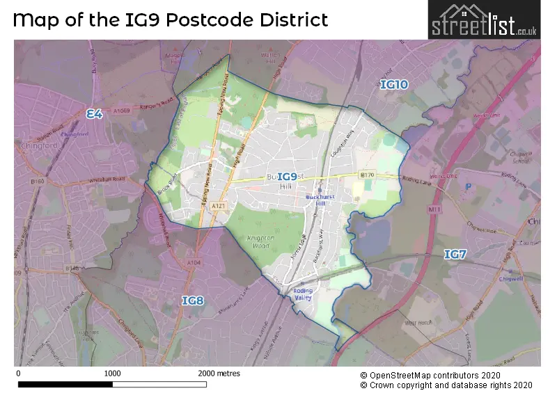
Map of the IG9 Postcode District
Explore the postcode district by using our interactive map.
Circles represent recorded crime; the larger the circle, the higher the crime rates.
Your support helps keep this site running!
If you enjoy using this website, consider buying me a coffee to help cover hosting costs.
Where is the IG9 District?
To give you an idea where the district is located we have created the following table showing nearby towns.
Nearest Towns to IG9
| Town | Distance (miles) | Direction |
|---|---|---|
| Chigwell | 1.58 | ESE |
| Loughton | 2.32 | NNE |
| Waltham Abbey | 4.26 | NNW |
| Waltham Cross | 5.18 | NW |
| Epping | 5.79 | NNE |
| Cheshunt | 6.36 | NW |
| Hoddesdon | 9.39 | NNW |
| City of London | 9.65 | SW |
| Harlow | 10.11 | NNE |
| Chipping Ongar | 10.31 | ENE |
| Potters Bar | 11.13 | WNW |
| City of Westminster | 11.28 | SW |
| Brentwood | 11.41 | E |
| Hertford | 12.81 | NNW |
| Ware | 13.34 | NNW |
| Borehamwood | 13.55 | W |
| Sawbridgeworth | 13.68 | NNE |
| Hatfield | 14.74 | NW |
| Dartford | 14.76 | SE |
| Radlett | 15.92 | WNW |
The post town for this district is BUCKHURST HILL.
Postcode Information for District IG9 (Total Geographical Postcodes: 353)
| Location | Post Town | Sector | Number of Postcodes |
|---|---|---|---|
| BUCKHURST HILL | BUCKHURST HILL | IG9 5 | 240 |
| BUCKHURST HILL | BUCKHURST HILL | IG9 6 | 113 |
Retail and Shopping in IG9
Street
Town
Locality
Number of Shops
Central Postcode
View on Google Maps
QUEENS ROAD
BUCKHURST HILL
96
IG9 5BU
View on Google Maps
LOUGHTON WAY
BUCKHURST HILL
12
IG9 6AR
View on Google Maps
STATION WAY
BUCKHURST HILL
10
IG9 6LN
View on Google Maps
| Street | Town | Locality | Number of Shops | Central Postcode | View on Google Maps |
|---|---|---|---|---|---|
| QUEENS ROAD | BUCKHURST HILL | 96 | IG9 5BU | View on Google Maps | |
| LOUGHTON WAY | BUCKHURST HILL | 12 | IG9 6AR | View on Google Maps | |
| STATION WAY | BUCKHURST HILL | 10 | IG9 6LN | View on Google Maps |
The primary settlement in the IG9 postcode district is Buckhurst Hill. It is located in both Essex and Greater London.
When it comes to local government, postal geography often disregards political borders. However, this district intersects the following councils: the district mostly encompasses the Epping Forest District (258 postal codes), and finally, the Redbridge London Boro area (32 postal codes).
The IG9 postal code covers the settlement of BUCKHURST HILL.
The IG9 Postcode shares a border with IG8 (WOODFORD GREEN), E4 (CHINGFORD), IG10 (LOUGHTON) and IG7 (CHIGWELL).


Dentists in the IG9 District
| # | Name | Address | Type | Contact |
|---|---|---|---|---|
| 1 | The Queens Dental Practice | 11 QUEENS ROAD , BUCKHURST HILL , ESSEX , IG9 5BZ | GENERAL DENTAL PRACTICE | |
| 2 | Dental Surgery | 2 RODING VIEW , BUCKHURST HILL , ESSEX , IG9 6AQ | GENERAL DENTAL PRACTICE | |
| 3 | Dental Surgery | 83 LOUGHTON WAY , BUCKHURST HILL , ESSEX , IG9 6AS | GENERAL DENTAL PRACTICE | |
| 4 | Al-faperio | 48A QUEENS ROAD , BUCKHURST HILL , IG9 5BY | GENERAL DENTAL PRACTICE |
Doctors in the IG9 District
| # | Name | Address | Type | Contact |
|---|---|---|---|---|
| 1 | Palmerston Road Surgery | , BUCKHURST HILL , ESSEX , IG9 5LT | GP PRACTICE | |
| 2 | Kings Medical Centre | , BUCKHURST HILL , ESSEX , IG9 5LP | GP PRACTICE | |
| 3 | The River Surgery | , BUCKHURST HILL , ESSEX , IG9 6BN | GP PRACTICE | |
| 4 | Buckhurst Way Clinic - Covid Local Vaccination Service 3 | , BUCKHURST HILL , IG9 6HP | BRANCH SURGERY |
Chemists in the IG9 District
| # | Name | Address | Type | Contact |
|---|---|---|---|---|
| 1 | Easter Pharmacy | 54 STATION WAY , BUCKHURST HILL , ESSEX , IG9 6LL | PHARMACY | |
| 2 | Asvacare Ltd | 32 QUEENS ROAD , BUCKHURST HILL , IG9 5BY | PHARMACY |
Opticians in the IG9 District
| # | Name | Address | Type | Contact |
|---|---|---|---|---|
| 1 | QUEENS ROAD OPTICIANS (ESSEX) | 55 QUEENS ROAD , BUCKHURST HILL , ESSEX , IG9 5BU | OPTICAL SITE | |
| 2 | HEATHER JAMESON AND ASSOCIATES - BUCKHURST HILL | 46 STATION WAY , BUCKHURST HILL , ESSEX , IG9 6LN | OPTICAL SITE |
Schools in the Sector
St John's Church of England Voluntary Controlled Primary School, Buckhurst Hill
Phase: Primary
Address: High Road , Buckhurst Hill
Postcode: IG9 5RX
Headteacher: Mr Chris Jarmain (Headteacher)
Ofsted Rating: Good
St John's Church of England Voluntary Controlled Primary School, Buckhurst Hill
Phase: Primary
Address: High Road , Buckhurst Hill
Postcode: IG9 5RX
Headteacher: Mr Jonathan Furness (Headteacher)
Ofsted Rating: Good
Buckhurst Hill Community Primary School
Phase: Primary
Address: Lower Queen's Road , Buckhurst Hill
Postcode: IG9 6DS
Headteacher: Mrs Alison Farquharson (Headteacher)
Ofsted Rating: Good
Stations in the Sector
No stations found in this postcode district.
Accessable Motorway Junctions
M11 J5
Average Driving Time from within the district: 5.67
Average Driving Distance: 2.81
Number of Postcodes that can access the Motorway Junction: 286
M25 J26
Average Driving Time from within the district: 9.53
Average Driving Distance: 5.56
Number of Postcodes that can access the Motorway Junction: 286
M25 J25
Average Driving Time from within the district: 12.34
Average Driving Distance: 8.92
Number of Postcodes that can access the Motorway Junction: 123
M25 J27
Average Driving Time from within the district: 13.75
Average Driving Distance: 10.12
Number of Postcodes that can access the Motorway Junction: 286
M11 J6
Average Driving Time from within the district: 14.91
Average Driving Distance: 11.36
Number of Postcodes that can access the Motorway Junction: 163
Weather Forecast for Chigwell
| Time Period | Icon | Description | Temperature | Rain Probability | Wind |
|---|---|---|---|---|---|
| 12:00 to 15:00 | Overcast | 6.0°C (feels like 3.0°C) | 9.00% | SSE 9 mph | |
| 15:00 to 18:00 | Overcast | 6.0°C (feels like 4.0°C) | 9.00% | S 7 mph | |
| 18:00 to 21:00 | Cloudy | 5.0°C (feels like 2.0°C) | 4.00% | SSE 7 mph | |
| 21:00 to 00:00 | Clear night | 3.0°C (feels like 0.0°C) | 1.00% | SSE 7 mph |
| Time Period | Icon | Description | Temperature | Rain Probability | Wind |
|---|---|---|---|---|---|
| 00:00 to 03:00 | Clear night | 2.0°C (feels like -1.0°C) | 0.00% | SE 4 mph | |
| 03:00 to 06:00 | Clear night | 1.0°C (feels like -2.0°C) | 1.00% | SE 4 mph | |
| 06:00 to 09:00 | Clear night | 0.0°C (feels like -2.0°C) | 0.00% | SE 4 mph | |
| 09:00 to 12:00 | Sunny day | 1.0°C (feels like -1.0°C) | 0.00% | SE 4 mph | |
| 12:00 to 15:00 | Sunny day | 5.0°C (feels like 3.0°C) | 0.00% | SSE 7 mph | |
| 15:00 to 18:00 | Sunny day | 6.0°C (feels like 4.0°C) | 0.00% | SSE 7 mph | |
| 18:00 to 21:00 | Clear night | 3.0°C (feels like 1.0°C) | 0.00% | S 4 mph | |
| 21:00 to 00:00 | Clear night | 2.0°C (feels like 0.0°C) | 1.00% | S 4 mph |
| Time Period | Icon | Description | Temperature | Rain Probability | Wind |
|---|---|---|---|---|---|
| 00:00 to 03:00 | Clear night | 1.0°C (feels like -2.0°C) | 1.00% | S 4 mph | |
| 03:00 to 06:00 | Clear night | 0.0°C (feels like -2.0°C) | 3.00% | SSW 4 mph | |
| 06:00 to 09:00 | Overcast | 1.0°C (feels like -2.0°C) | 9.00% | SSW 4 mph | |
| 09:00 to 12:00 | Overcast | 2.0°C (feels like 0.0°C) | 9.00% | SSW 4 mph | |
| 12:00 to 15:00 | Overcast | 5.0°C (feels like 3.0°C) | 8.00% | SSW 7 mph | |
| 15:00 to 18:00 | Sunny day | 7.0°C (feels like 5.0°C) | 1.00% | SSW 7 mph | |
| 18:00 to 21:00 | Partly cloudy (night) | 5.0°C (feels like 2.0°C) | 1.00% | S 7 mph | |
| 21:00 to 00:00 | Partly cloudy (night) | 4.0°C (feels like 1.0°C) | 2.00% | S 7 mph |
| Time Period | Icon | Description | Temperature | Rain Probability | Wind |
|---|---|---|---|---|---|
| 00:00 to 03:00 | Partly cloudy (night) | 4.0°C (feels like 1.0°C) | 3.00% | SSW 7 mph | |
| 03:00 to 06:00 | Partly cloudy (night) | 4.0°C (feels like 1.0°C) | 2.00% | S 9 mph | |
| 06:00 to 09:00 | Clear night | 4.0°C (feels like 1.0°C) | 2.00% | SSW 9 mph | |
| 09:00 to 12:00 | Cloudy | 5.0°C (feels like 2.0°C) | 4.00% | S 9 mph | |
| 12:00 to 15:00 | Cloudy | 8.0°C (feels like 5.0°C) | 5.00% | SSW 11 mph | |
| 15:00 to 18:00 | Cloudy | 9.0°C (feels like 7.0°C) | 7.00% | SSW 11 mph | |
| 18:00 to 21:00 | Cloudy | 8.0°C (feels like 6.0°C) | 15.00% | SSW 11 mph | |
| 21:00 to 00:00 | Light rain shower (night) | 8.0°C (feels like 5.0°C) | 34.00% | SW 9 mph |
| Time Period | Icon | Description | Temperature | Rain Probability | Wind |
|---|---|---|---|---|---|
| 00:00 to 03:00 | Clear night | 6.0°C (feels like 4.0°C) | 8.00% | WSW 7 mph | |
| 03:00 to 06:00 | Clear night | 5.0°C (feels like 2.0°C) | 5.00% | W 7 mph | |
| 06:00 to 09:00 | Clear night | 3.0°C (feels like 1.0°C) | 2.00% | WNW 7 mph | |
| 09:00 to 12:00 | Partly cloudy (day) | 4.0°C (feels like 1.0°C) | 1.00% | NW 4 mph | |
| 12:00 to 15:00 | Cloudy | 7.0°C (feels like 5.0°C) | 4.00% | NW 7 mph | |
| 15:00 to 18:00 | Cloudy | 8.0°C (feels like 6.0°C) | 5.00% | NNW 4 mph | |
| 18:00 to 21:00 | Cloudy | 4.0°C (feels like 3.0°C) | 4.00% | N 4 mph | |
| 21:00 to 00:00 | Cloudy | 3.0°C (feels like 1.0°C) | 4.00% | N 4 mph |
| Postal Sector | Delivery Office |
|---|---|
| IG9 5 | Woodford Green Delivery Office |
| IG9 6 | Woodford Green Delivery Office |
| I | G | 9 | - | X | X | X |
| I | G | 9 | Space | Numeric | Letter | Letter |
Street List for the IG9 District
Current Monthly Rental Prices
| # Bedrooms | Min Price | Max Price | Avg Price |
|---|---|---|---|
| 1 | £1,250 | £1,595 | £1,424 |
| 2 | £1,500 | £2,100 | £1,800 |
| 3 | £2,100 | £2,995 | £2,482 |
| 4 | £2,500 | £4,500 | £3,450 |
Current House Prices
| # Bedrooms | Min Price | Max Price | Avg Price |
|---|---|---|---|
| £199,995 | £240,000 | £213,332 | |
| 1 | £150,000 | £450,000 | £290,000 |
| 2 | £181,500 | £775,000 | £399,594 |
| 3 | £251,000 | £1,000,000 | £623,138 |
| 4 | £600,000 | £1,695,000 | £996,154 |
| 5 | £700,000 | £1,795,000 | £1,188,333 |
| 6 | £1,600,000 | £2,500,000 | £2,200,000 |
Estate Agents
| Logo | Name | Brand Name | Address | Contact Number |
|---|---|---|---|---|
 | Buckhurst Hill | Farr O'Neil | 76A Queens Road, Buckhurst Hill, IG9 5BS | 020 3872 3542 |
 | Buckhurst Hill | Caplen Estates | Caplen Estates 12 Queens Road, Buckhurst Hill, Essex, IG9 5BY | 020 3907 9826 |
 | Buckhurst Hill | Churchill Estates | 17 Queens Road, Buckhurst Hill, IG9 5BZ | 020 3834 8569 |
 | Buckhurst Hill | Butler & Stag | 184, Queens Road, Buckhurst Hill, IG9 5BD | 020 8629 1598 |
 | National | The Good Estate Agent | 118 Sandgate Road, Folkestone, CT20 2BW | 01303 761699 |
Yearly House Price Averages for the District
| Type of Property | 2018 Average | 2018 Sales | 2017 Average | 2017 Sales | 2016 Average | 2016 Sales | 2015 Average | 2015 Sales |
|---|---|---|---|---|---|---|---|---|
| Detached | £930,436 | 28 | £955,450 | 20 | £900,281 | 32 | £829,205 | 36 |
| Semi-Detached | £695,048 | 42 | £685,586 | 58 | £638,771 | 50 | £549,508 | 62 |
| Terraced | £569,870 | 59 | £570,561 | 49 | £536,967 | 55 | £492,968 | 62 |
| Flats | £353,770 | 61 | £369,401 | 78 | £344,466 | 86 | £320,119 | 114 |