
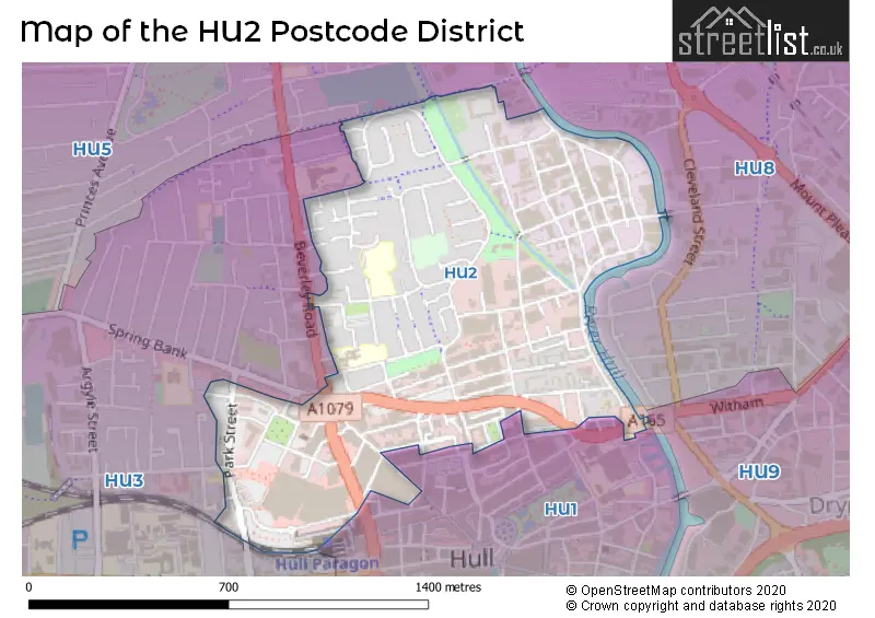
Map of the HU2 Postcode District
Explore the postcode district by using our interactive map.
Circles represent recorded crime; the larger the circle, the higher the crime rates.
Your support helps keep this site running!
If you enjoy using this website, consider buying me a coffee to help cover hosting costs.
Where is the HU2 District?
To give you an idea where the district is located we have created the following table showing nearby towns.
Nearest Towns to HU2
| Town | Distance (miles) | Direction |
|---|---|---|
| Kingston upon Hull | 0.58 | SE |
| Cottingham | 3.62 | NW |
| Hessle | 4.35 | WSW |
| Hedon | 5.88 | E |
| Barton-upon-Humber | 6.12 | SW |
| Beverley | 7.41 | NNW |
| South Cave | 10.71 | W |
| Immingham | 10.79 | SSE |
| Winterton | 12.49 | WSW |
| Hornsea | 13.20 | NNE |
| Brigg | 15.04 | SSW |
| Withernsea | 15.32 | E |
| Market Weighton | 15.54 | WNW |
| Grimsby | 16.66 | SE |
| Scunthorpe | 16.72 | SW |
| Driffield | 18.05 | NNW |
| Cleethorpes | 18.35 | SE |
| Howden | 21.61 | W |
| Kirton in Lindsey | 21.66 | SSW |
| Pocklington | 21.77 | NW |
The post town for this district is HULL.
Postcode Information for District HU2 (Total Geographical Postcodes: 398)
| Location | Post Town | Sector | Number of Postcodes |
|---|---|---|---|
| HULL | HULL | HU2 8 | 196 |
| HULL | HULL | HU2 0 | 130 |
| HULL | HULL | HU2 9 | 72 |
Retail and Shopping in HU2
Street
Town
Locality
Number of Shops
Central Postcode
View on Google Maps
FERENSWAY
HULL
59
HU2 8LN
View on Google Maps
PROSPECT STREET
HULL
53
HU2 8PW
View on Google Maps
CAROLINE STREET
HULL
9
HU2 8DY
View on Google Maps
CHARLES STREET
HULL
8
HU2 8DF
View on Google Maps
| Street | Town | Locality | Number of Shops | Central Postcode | View on Google Maps |
|---|---|---|---|---|---|
| FERENSWAY | HULL | 59 | HU2 8LN | View on Google Maps | |
| PROSPECT STREET | HULL | 53 | HU2 8PW | View on Google Maps | |
| CAROLINE STREET | HULL | 9 | HU2 8DY | View on Google Maps | |
| CHARLES STREET | HULL | 8 | HU2 8DF | View on Google Maps |
The primary settlement in the HU2 postcode district is Hull, located in the East Riding of Yorkshire. Hull is the main focus, with a count of 65. Other significant settlements in the district include HU2 8, also in Hull, with a count of 98, and HU2 9 in Hull, with a count of 36.
When it comes to local government, postal geography often disregards political borders. However, this district intersects the following councils: the district mostly encompasses the City of Kingston upon Hull (B) area with a total of 195 postal codes.
The HU2 postal code covers the settlement of HULL.
The HU2 Postcode shares a border with HU3 (HULL), HU5 (HULL), HU8 (HULL, Garden Village) and HU1 (HULL).


Dentists in the HU2 District
| # | Name | Address | Type | Contact |
|---|---|---|---|---|
| 1 | 30 Percy Street (dental Surgery) | 30 PERCY STREET , HULL , NORTH HUMBERSIDE , HU2 8HL | GENERAL DENTAL PRACTICE | |
| 2 | Freetown Way Dental Surgery | SUITE ONE , 15 FREETOWN WAY , HULL , NORTH HUMBERSIDE , HU2 8JQ | GENERAL DENTAL PRACTICE | |
| 3 | Mr Br Davies | UNIT 116 , HULL MICROFIRMS CENTRE , 266-290 WINCOLMLEE , HULL , NORTH HUMBERSIDE , HU2 0PZ | GENERAL DENTAL PRACTICE | |
| 4 | John C Glassby Dental Surgery | 3 KINGSTON SQUARE , HULL , NORTH HUMBERSIDE , HU2 8DA | GENERAL DENTAL PRACTICE |
Doctors in the HU2 District
No Doctors found in this district.
Chemists in the HU2 District
| # | Name | Address | Type | Contact |
|---|---|---|---|---|
| 1 | Boots | UNITS 15A , ST STEPHENS , 110 FERENSWAY , HULL , HU2 8LN | PHARMACY | |
| 2 | Tesco Instore Pharmacy | ST STEPHENS CENTRE , PARK STREET , HULL , HU2 8LN | PHARMACY |
Opticians in the HU2 District
| # | Name | Address | Type | Contact |
|---|---|---|---|---|
| 1 | VISION EXPRESS (HULL) | UNIT 27 ST STEPHENS CENTRE , HULL , NORTH HUMBERSIDE , HU2 8LN | OPTICAL SITE | |
| 2 | TESCO OPTICIANS (HULL) | PARK STREET , HULL , NORTH HUMBERSIDE , HU2 8RW | OPTICAL SITE | |
| 3 | BRIGHT EYES (OPTICAL) LTD | 3 PERCY STREET , HULL , NORTH HUMBERSIDE , HU2 8HH | OPTICAL SITE | |
| 4 | HULL ST STEPHENS EXTRA | 110 FERENSWAY , HULL , NORTH HUMBERSIDE , HU2 8LN | OPTICAL SITE | |
| 5 | BOOTS OPTICIANS (ST STEPHENS SHOPPING CENTRE) | UNIT 16-17 , ST. STEPHENS , 110 FERENSWAY , HULL , HU2 8LN | OPTICAL SITE |
Schools in the Sector
Rise Academy
Phase: Not applicable
Address: Fountain Road , Hull
Postcode: HU2 0LH
Headteacher: Ms Sue Yardley (Headteacher)
Ofsted Rating: Good
Rise Academy
Phase: Not applicable
Address: Fountain Road , Hull
Postcode: HU2 0LH
Headteacher: Mr Philip Mountain Wade (Headteacher)
Ofsted Rating: Good
Ron Dearing UTC
Phase: Secondary
Address: Kingston Square , Hull
Postcode: HU2 8BQ
Headteacher: Mrs Sarah Pashley ()
Ofsted Rating: Outstanding
St Charles' Roman Catholic Voluntary Aided Primary School
Phase: Primary
Address: Norfolk Street , Hull
Postcode: HU2 9AA
Headteacher: Mrs A McGrath (Acting Head of School)
Ofsted Rating: Requires improvement
St Charles Voluntary Catholic Academy
Phase: Primary
Address: Norfolk Street , Hull
Postcode: HU2 9AA
Headteacher: Mrs S Woodmansey (Headteacher)
Ofsted Rating: Requires improvement
Clifton Primary School
Phase: Primary
Address: Burslem Street , Hull
Postcode: HU2 9BP
Headteacher: Mrs Rachel Wilkes (Headteacher)
Ofsted Rating: Outstanding
Clifton Primary School
Phase: Primary
Address: Burslem Street , Hull
Postcode: HU2 9BP
Headteacher: Mrs Terri Hadfield (Headteacher)
Ofsted Rating: Outstanding
Little Weighton Rowley Church of England Voluntary Controlled Primary School
Phase: Primary
Address: White Gap Road , Little Weighton , Cottingham
Postcode: HU20 3XE
Headteacher: Miss Susie Varley (Headteacher)
Ofsted Rating: Requires improvement
Stations in the Sector
No stations found in this postcode district.
Accessable Motorway Junctions
M62 J38
Average Driving Time from within the district: 19.37
Average Driving Distance: 17.08
Number of Postcodes that can access the Motorway Junction: 199
M180 J5
Average Driving Time from within the district: 22.18
Average Driving Distance: 18.34
Number of Postcodes that can access the Motorway Junction: 199
M62 J37
Average Driving Time from within the district: 26.97
Average Driving Distance: 25.17
Number of Postcodes that can access the Motorway Junction: 199
M180 J4
Average Driving Time from within the district: 28.35
Average Driving Distance: 24.73
Number of Postcodes that can access the Motorway Junction: 199
M180 J3
Average Driving Time from within the district: 38.36
Average Driving Distance: 34.99
Number of Postcodes that can access the Motorway Junction: 199
Weather Forecast for Hull
| Time Period | Icon | Description | Temperature | Rain Probability | Wind |
|---|---|---|---|---|---|
| 12:00 to 15:00 | Overcast | 6.0°C (feels like 3.0°C) | 9.00% | S 9 mph | |
| 15:00 to 18:00 | Overcast | 6.0°C (feels like 3.0°C) | 9.00% | S 9 mph | |
| 18:00 to 21:00 | Overcast | 5.0°C (feels like 2.0°C) | 9.00% | S 9 mph | |
| 21:00 to 00:00 | Overcast | 5.0°C (feels like 1.0°C) | 9.00% | S 11 mph |
| Time Period | Icon | Description | Temperature | Rain Probability | Wind |
|---|---|---|---|---|---|
| 00:00 to 03:00 | Cloudy | 4.0°C (feels like 0.0°C) | 5.00% | S 11 mph | |
| 03:00 to 06:00 | Cloudy | 2.0°C (feels like -2.0°C) | 5.00% | S 11 mph | |
| 06:00 to 09:00 | Partly cloudy (night) | 1.0°C (feels like -3.0°C) | 2.00% | S 9 mph | |
| 09:00 to 12:00 | Sunny day | 2.0°C (feels like -2.0°C) | 3.00% | S 9 mph | |
| 12:00 to 15:00 | Sunny day | 5.0°C (feels like 2.0°C) | 3.00% | SSW 9 mph | |
| 15:00 to 18:00 | Sunny day | 6.0°C (feels like 3.0°C) | 2.00% | SSW 9 mph | |
| 18:00 to 21:00 | Clear night | 4.0°C (feels like 1.0°C) | 2.00% | SSW 7 mph | |
| 21:00 to 00:00 | Clear night | 3.0°C (feels like 0.0°C) | 1.00% | SSW 9 mph |
| Time Period | Icon | Description | Temperature | Rain Probability | Wind |
|---|---|---|---|---|---|
| 00:00 to 03:00 | Partly cloudy (night) | 3.0°C (feels like 0.0°C) | 1.00% | SSW 9 mph | |
| 03:00 to 06:00 | Clear night | 3.0°C (feels like -1.0°C) | 2.00% | SSW 9 mph | |
| 06:00 to 09:00 | Cloudy | 3.0°C (feels like -1.0°C) | 5.00% | SSW 9 mph | |
| 09:00 to 12:00 | Cloudy | 3.0°C (feels like 0.0°C) | 5.00% | SSW 9 mph | |
| 12:00 to 15:00 | Cloudy | 6.0°C (feels like 3.0°C) | 5.00% | SSW 11 mph | |
| 15:00 to 18:00 | Cloudy | 8.0°C (feels like 5.0°C) | 5.00% | SSW 11 mph | |
| 18:00 to 21:00 | Partly cloudy (night) | 7.0°C (feels like 4.0°C) | 2.00% | SSW 11 mph | |
| 21:00 to 00:00 | Partly cloudy (night) | 6.0°C (feels like 3.0°C) | 3.00% | SSW 13 mph |
| Time Period | Icon | Description | Temperature | Rain Probability | Wind |
|---|---|---|---|---|---|
| 00:00 to 03:00 | Cloudy | 6.0°C (feels like 2.0°C) | 7.00% | SSW 13 mph | |
| 03:00 to 06:00 | Cloudy | 6.0°C (feels like 3.0°C) | 15.00% | SSW 13 mph | |
| 06:00 to 09:00 | Cloudy | 7.0°C (feels like 3.0°C) | 15.00% | SSW 13 mph | |
| 09:00 to 12:00 | Partly cloudy (day) | 7.0°C (feels like 4.0°C) | 13.00% | SSW 13 mph | |
| 12:00 to 15:00 | Partly cloudy (day) | 9.0°C (feels like 6.0°C) | 13.00% | SSW 13 mph | |
| 15:00 to 18:00 | Cloudy | 10.0°C (feels like 7.0°C) | 12.00% | SW 13 mph | |
| 18:00 to 21:00 | Partly cloudy (night) | 8.0°C (feels like 5.0°C) | 8.00% | SW 11 mph | |
| 21:00 to 00:00 | Partly cloudy (night) | 7.0°C (feels like 4.0°C) | 7.00% | WSW 9 mph |
| Postal Sector | Delivery Office |
|---|---|
| HU2 0 | Hull City Delivery Office |
| HU2 8 | Hull City Delivery Office |
| HU2 9 | Hull City Delivery Office |
| H | U | 2 | - | X | X | X |
| H | U | 2 | Space | Numeric | Letter | Letter |
Street List for the HU2 District
Current Monthly Rental Prices
| # Bedrooms | Min Price | Max Price | Avg Price |
|---|---|---|---|
| 1 | £550 | £550 | £550 |
| 2 | £525 | £900 | £684 |
| 3 | £950 | £950 | £950 |
Current House Prices
| # Bedrooms | Min Price | Max Price | Avg Price |
|---|---|---|---|
| 1 | £65,000 | £109,950 | £81,970 |
| 2 | £65,000 | £140,000 | £95,996 |
| 24 | £1,300,000 | £1,300,000 | £1,300,000 |
Estate Agents
| Logo | Name | Brand Name | Address | Contact Number |
|---|---|---|---|---|
 | Willerby | Humber Sales & Lettings Limited | 90 Willerby Road, Hull, HU5 5JN | 01482 251692 |
 | Hull | Reeds Rains | 508 Holderness Road, Hull, HU9 3DS | 01482 251835 |
 | Sutton-on-Hull | Taylors | 5a College Street, Sutton-On-Hull, Hull, HU7 4UE | 01482 424976 |
 | York | Susie Smith Lettings | Suite 12B Fishergate, York, YO10 4UA | 01904 935476 |
 | Hull | Lime Property | The Pod St. Andrews Quay, Hull, HU3 4SA | 01482 251700 |
Yearly House Price Averages for the District
| Type of Property | 2018 Average | 2018 Sales | 2017 Average | 2017 Sales | 2016 Average | 2016 Sales | 2015 Average | 2015 Sales |
|---|---|---|---|---|---|---|---|---|
| Detached | £0 | 0 | £0 | 0 | £0 | 0 | £0 | 0 |
| Semi-Detached | £89,000 | 1 | £0 | 0 | £0 | 0 | £41,000 | 1 |
| Terraced | £82,067 | 15 | £100,647 | 17 | £75,000 | 6 | £84,513 | 20 |
| Flats | £68,916 | 25 | £74,161 | 18 | £79,395 | 19 | £72,985 | 36 |