A wide range of spatial data has been analysed to present this overview of the HU19 2 Postcode sector. If you would like anything added, please contact us.
The HU19 2 postcode sector is within the county of East Riding of Yorkshire.
Did you know? According to the 2021 Census, the HU19 2 postcode sector is home to a bustling 6,960 residents!
Given that each sector allows for 400 unique postcode combinations. Letters C, I, K, M, O and V are not allowed in the last two letters of a postcode. With 195 postcodes already in use, this leaves 205 units available.
The largest settlement in the HU19 2 postal code is WITHERNSEA followed by Hollym, and Waxholme.
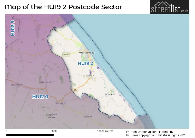
The HU19 2 Postcode shares a border with HU12 0 (Patrington, Tunstall, Easington).
Map of the HU19 2 Postcode Sector
Explore the HU19 2 postcode sector by using our interactive map.
The sector is within the post town of WITHERNSEA.
HU19 2 is a postcode sector within the HU19 postcode district which is within the HU Hull postcode area.
The Royal Mail delivery office for the HU19 2 postal sector is the Withernsea Scale Payment Delivery Office.
The area of the HU19 2 postcode sector is 13.39 square miles which is 34.68 square kilometres or 8,569.03 square acres.
Your support helps keep this site running!
If you enjoy using this website, consider buying me a coffee to help cover hosting costs.


| H | U | 1 | 9 | - | 2 | X | X |
| H | U | 1 | 9 | Space | 2 | Letter | Letter |
Official List of Streets
WITHERNSEA (84 Streets)
(24 Streets)
Hollym (12 Streets)
Rimswell (3 Streets)
Holmpton (6 Streets)
Waxholme (1 Streets)
Unofficial Streets or Alternative Spellings
Skeffling
OUT NEWTON ROADWelwick
WAKEFIELD LANEPatrington
HOLLYM ROADWeather Forecast for HU19 2
Weather Forecast for Withernsea (East Riding Of Yorkshire)
| Time Period | Icon | Description | Temperature | Rain Probability | Wind |
|---|---|---|---|---|---|
| 18:00 to 21:00 | Clear night | 2.0°C (feels like -2.0°C) | 0.00% | WSW 7 mph | |
| 21:00 to 00:00 | Clear night | 1.0°C (feels like -3.0°C) | 1.00% | WSW 9 mph |
| Time Period | Icon | Description | Temperature | Rain Probability | Wind |
|---|---|---|---|---|---|
| 00:00 to 03:00 | Cloudy | 2.0°C (feels like -2.0°C) | 4.00% | SW 9 mph | |
| 03:00 to 06:00 | Cloudy | 2.0°C (feels like -1.0°C) | 16.00% | SW 9 mph | |
| 06:00 to 09:00 | Light rain | 3.0°C (feels like -1.0°C) | 47.00% | S 9 mph | |
| 09:00 to 12:00 | Overcast | 3.0°C (feels like 0.0°C) | 12.00% | S 9 mph | |
| 12:00 to 15:00 | Overcast | 5.0°C (feels like 3.0°C) | 9.00% | SSW 7 mph | |
| 15:00 to 18:00 | Overcast | 5.0°C (feels like 3.0°C) | 10.00% | SE 4 mph | |
| 18:00 to 21:00 | Overcast | 5.0°C (feels like 3.0°C) | 9.00% | S 4 mph | |
| 21:00 to 00:00 | Overcast | 4.0°C (feels like 2.0°C) | 11.00% | SSW 4 mph |
| Time Period | Icon | Description | Temperature | Rain Probability | Wind |
|---|---|---|---|---|---|
| 00:00 to 03:00 | Overcast | 4.0°C (feels like 2.0°C) | 11.00% | SSW 7 mph | |
| 03:00 to 06:00 | Overcast | 4.0°C (feels like 2.0°C) | 11.00% | SSW 7 mph | |
| 06:00 to 09:00 | Overcast | 3.0°C (feels like 0.0°C) | 10.00% | SSW 9 mph | |
| 09:00 to 12:00 | Overcast | 4.0°C (feels like 0.0°C) | 9.00% | S 11 mph | |
| 12:00 to 15:00 | Overcast | 6.0°C (feels like 2.0°C) | 9.00% | S 13 mph | |
| 15:00 to 18:00 | Overcast | 6.0°C (feels like 2.0°C) | 9.00% | S 13 mph | |
| 18:00 to 21:00 | Overcast | 5.0°C (feels like 1.0°C) | 9.00% | S 11 mph | |
| 21:00 to 00:00 | Overcast | 4.0°C (feels like 0.0°C) | 8.00% | S 13 mph |
| Time Period | Icon | Description | Temperature | Rain Probability | Wind |
|---|---|---|---|---|---|
| 00:00 to 03:00 | Cloudy | 3.0°C (feels like -2.0°C) | 5.00% | S 13 mph | |
| 03:00 to 06:00 | Overcast | 3.0°C (feels like -2.0°C) | 8.00% | S 13 mph | |
| 06:00 to 09:00 | Cloudy | 2.0°C (feels like -2.0°C) | 8.00% | S 13 mph | |
| 09:00 to 12:00 | Cloudy | 3.0°C (feels like -1.0°C) | 12.00% | SSW 13 mph | |
| 12:00 to 15:00 | Cloudy | 6.0°C (feels like 2.0°C) | 11.00% | SSW 11 mph | |
| 15:00 to 18:00 | Partly cloudy (day) | 6.0°C (feels like 3.0°C) | 6.00% | SW 11 mph | |
| 18:00 to 21:00 | Clear night | 4.0°C (feels like 1.0°C) | 4.00% | SW 9 mph | |
| 21:00 to 00:00 | Clear night | 4.0°C (feels like 0.0°C) | 4.00% | SW 9 mph |
| Time Period | Icon | Description | Temperature | Rain Probability | Wind |
|---|---|---|---|---|---|
| 00:00 to 03:00 | Partly cloudy (night) | 3.0°C (feels like 0.0°C) | 2.00% | SW 9 mph | |
| 03:00 to 06:00 | Cloudy | 3.0°C (feels like -1.0°C) | 5.00% | SW 9 mph | |
| 06:00 to 09:00 | Overcast | 3.0°C (feels like -1.0°C) | 7.00% | SSW 9 mph | |
| 09:00 to 12:00 | Cloudy | 4.0°C (feels like 0.0°C) | 5.00% | SSW 11 mph | |
| 12:00 to 15:00 | Cloudy | 6.0°C (feels like 3.0°C) | 5.00% | SSW 11 mph | |
| 15:00 to 18:00 | Cloudy | 7.0°C (feels like 4.0°C) | 5.00% | SSW 13 mph | |
| 18:00 to 21:00 | Cloudy | 6.0°C (feels like 2.0°C) | 4.00% | S 13 mph | |
| 21:00 to 00:00 | Cloudy | 5.0°C (feels like 1.0°C) | 5.00% | S 16 mph |
Schools and Places of Education Within the HU19 2 Postcode Sector
Sycamore House School
Other independent special school
365 Queens Street, , , HU19 2NT
Head: Mrs Karen Jessop
Ofsted Rating: Good
Inspection: 2019-07-03 (2038 days ago)
Website: Visit Sycamore House School Website
Phone: 01964247224
Number of Pupils: 4
Withernsea High School
Community school
Hull Road, Withernsea, , HU19 2EQ
Head: Mr Mark Crofts
Ofsted Rating: Good
Inspection: 2021-11-11 (1176 days ago)
Website: Visit Withernsea High School Website
Phone: 01964613133
Number of Pupils: 763
Withernsea Primary School
Academy converter
Hull Road, Withernsea, , HU19 2EG
Head: Mr James Hartmann
Ofsted Rating: Good
Inspection: 2023-09-20 (498 days ago)
Website: Visit Withernsea Primary School Website
Phone: 01964612800
Number of Pupils: 496
House Prices in the HU19 2 Postcode Sector
| Type of Property | 2018 Average | 2018 Sales | 2017 Average | 2017 Sales | 2016 Average | 2016 Sales | 2015 Average | 2015 Sales |
|---|---|---|---|---|---|---|---|---|
| Detached | £148,675 | 20 | £171,796 | 25 | £165,208 | 26 | £145,912 | 40 |
| Semi-Detached | £113,486 | 37 | £119,533 | 27 | £107,455 | 43 | £101,768 | 55 |
| Terraced | £87,811 | 70 | £88,188 | 67 | £83,432 | 65 | £80,644 | 70 |
| Flats | £60,250 | 2 | £36,539 | 2 | £35,500 | 3 | £0 | 0 |
Important Postcodes HU19 2 in the Postcode Sector
HU19 2EG is the postcode for Infant Block, Withernsea Primary School, Hull Road, Withernsea Infant School, Hull Road, Withernsea Junior School, Hull Road, SOUTH BLOCK, Withernsea Primary School, Hull Road, and NORTH BLOCK, Withernsea Primary School, Hull Road
HU19 2EQ is the postcode for WITHERNSEA CHILDREN'S CENTRE, Withernsea Vocational Learning Centre, Withernsea High School, HOLDERNESS LEARNING CENTRE, Withernsea High School, Hull Road, SPORTS HALL, Withernsea High School, Hull Road, WITHERNSEA VOCATIONAL LEARNING CENTRE, WITHERNSEA HIGH SCHOOL, HULL ROAD, Withernsea High School, Hull Road, and WITHERNSEA HIGH SCHOOL, HULL ROAD, WITHERNSEA
HU19 2HH is the postcode for East Riding of Yorkshire Council, Withernsea Library, Queen Street
HU19 2JH is the postcode for Humberside Police, Police Station, Station Road
HU19 2LH is the postcode for Day Centre, Victoria Avenue
HU19 2PZ is the postcode for St. Nicholas Surgery, Queen Street
HU19 2QA is the postcode for East Riding of Yorkshire Council, Pavilion Leisure Centre, Queen Street, EAST RIDING LEISURE WITHERNSEA, STATION ROAD, and East Riding Leisure Withernsea, Queen Street
HU19 2QB is the postcode for Withernsea Community Hospital, Queen Street, and East Riding Of Yorkshire PCT, Withernsea Community Hospital
| The HU19 2 Sector is within these Local Authorities |
|
|---|---|
| The HU19 2 Sector is within these Counties |
|
| The HU19 2 Sector is within these Water Company Areas |
|
Tourist Attractions within the HU19 2 Postcode Area
We found 1 visitor attractions within the HU19 postcode area
| Withernsea Lighthouse Museum |
|---|
| Museums & Art Galleries |
| Museum and / or Art Gallery |
| View Withernsea Lighthouse Museum on Google Maps |