
Map of the HU15 Postcode District
Explore the postcode district by using our interactive map.
Circles represent recorded crime; the larger the circle, the higher the crime rates.
Your support helps keep this site running!
If you enjoy using this website, consider buying me a coffee to help cover hosting costs.
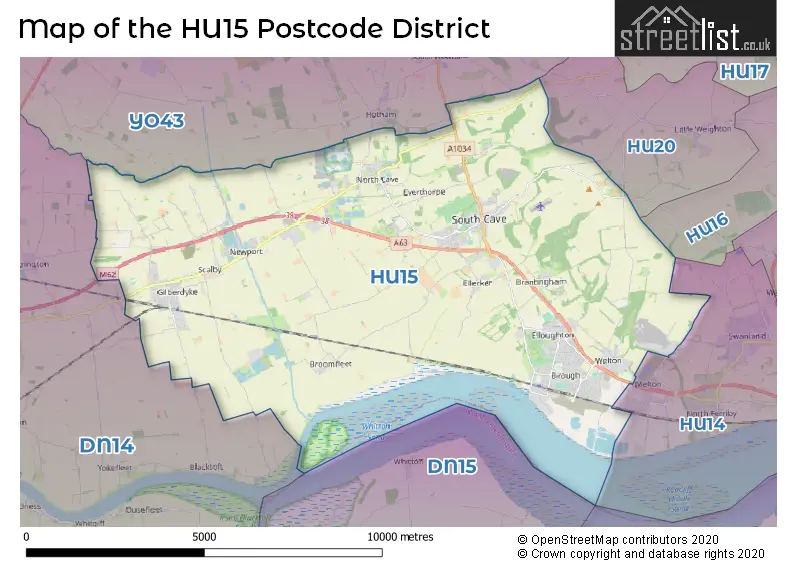
Where is the HU15 District?
To give you an idea where the district is located we have created the following table showing nearby towns.
Nearest Towns to HU15
| Town | Distance (miles) | Direction |
|---|---|---|
| Winterton | 7.19 | SSE |
| Market Weighton | 7.62 | N |
| Hessle | 8.59 | ESE |
| Cottingham | 9.31 | E |
| Howden | 9.47 | W |
| Barton-upon-Humber | 9.53 | ESE |
| Goole | 10.26 | WSW |
| Beverley | 10.30 | NE |
| Scunthorpe | 11.38 | S |
| Kingston upon Hull | 12.52 | E |
| Crowle | 13.12 | SW |
| Pocklington | 13.38 | NNW |
| Brigg | 15.44 | SSE |
| Thorne | 16.66 | SW |
| Epworth | 17.66 | SSW |
| Selby | 17.82 | W |
| Hedon | 18.01 | E |
| Driffield | 19.04 | NNE |
| Kirton in Lindsey | 19.52 | S |
The post town for this district is BROUGH.
Postcode Information for District HU15 (Total Geographical Postcodes: 701)
| Location | Post Town | Sector | Number of Postcodes |
|---|---|---|---|
| BROUGH | BROUGH | HU15 1 | 185 |
| South Cave | BROUGH | HU15 2 | 97 |
| Gilberdyke | BROUGH | HU15 2 | 96 |
| Elloughton | BROUGH | HU15 1 | 91 |
| Welton | BROUGH | HU15 1 | 69 |
| North Cave | BROUGH | HU15 2 | 55 |
| Newport | BROUGH | HU15 2 | 44 |
| Broomfleet | BROUGH | HU15 1 | 14 |
| Ellerker | BROUGH | HU15 2 | 13 |
| Brantingham | BROUGH | HU15 1 | 12 |
| Everthorpe | BROUGH | HU15 2 | 6 |
| Sandholme | BROUGH | HU15 2 | 5 |
| Riplingham | BROUGH | HU15 1 | 4 |
| Hive | BROUGH | HU15 2 | 3 |
| Drewton | BROUGH | HU15 2 | 2 |
| Everthorpe | BROUGH | HU15 1 | 2 |
| Crabley Creek | BROUGH | HU15 1 | 1 |
| Newport | BROUGH | HU15 1 | 1 |
| BROUGH | BROUGH | HU15 2 | 1 |
Retail and Shopping in HU15
Street
Town
Locality
Number of Shops
Central Postcode
View on Google Maps
MARKET PLACE
BROUGH
SOUTH CAVE
17
HU15 2AS
View on Google Maps
WELTON ROAD
BROUGH
16
HU15 1AB
View on Google Maps
SKILLINGS LANE
BROUGH
12
HU15 1BA
View on Google Maps
MAIN ROAD
BROUGH
NEWPORT
10
HU15 2QS
View on Google Maps
SCALBY LANE
BROUGH
GILBERDYKE
6
HU15 2UJ
View on Google Maps
| Street | Town | Locality | Number of Shops | Central Postcode | View on Google Maps |
|---|---|---|---|---|---|
| MARKET PLACE | BROUGH | SOUTH CAVE | 17 | HU15 2AS | View on Google Maps |
| WELTON ROAD | BROUGH | 16 | HU15 1AB | View on Google Maps | |
| SKILLINGS LANE | BROUGH | 12 | HU15 1BA | View on Google Maps | |
| MAIN ROAD | BROUGH | NEWPORT | 10 | HU15 2QS | View on Google Maps |
| SCALBY LANE | BROUGH | GILBERDYKE | 6 | HU15 2UJ | View on Google Maps |
The primary settlement in the HU15 postcode district is Brough, located in the East Riding of Yorkshire, England. Other significant settlements in this district include Brantingham, Broomfleet, Elloughton, Welton, Drewton, Ellerker, Gilberdyke, Hive, Newport, North Cave, Sandholme, and South Cave. The most significant Post Town in this district is BROUGH.
When it comes to local government, postal geography often disregards political borders. However, this district intersects the following councils: the district mostly encompasses the East Riding of Yorkshire area with a total of 667 postal codes.
The largest settlement in the HU15 postal code is BROUGH followed by South Cave, and Gilberdyke.
The postcode area has a boundary with The Humber.
The HU15 Postcode shares a border with HU14 (Swanland, NORTH FERRIBY, Melton), YO43 (Market Weighton, Holme-on-Spalding-Moor, North Newbald) and DN14 (GOOLE, Howden, Eggborough).


Dentists in the HU15 District
| # | Name | Address | Type | Contact |
|---|---|---|---|---|
| 1 | Dental Surgery | 40 - 44 CHURCH STREET , SOUTH CAVE , BROUGH , NORTH HUMBERSIDE , HU15 2EP | GENERAL DENTAL PRACTICE | |
| 2 | Time For Teeth Hmp Humber | EVERTHORPE , BROUGH , NORTH HUMBERSIDE , HU15 1RB | GENERAL DENTAL PRACTICE | |
| 3 | Brough Dental Studio | 19 WELTON ROAD , BROUGH , NORTH HUMBERSIDE , HU15 1DR | GENERAL DENTAL PRACTICE | |
| 4 | Cosmetic & Family Dentistry | 104 WELTON ROAD , BROUGH , NORTH HUMBERSIDE , HU15 1BH | GENERAL DENTAL PRACTICE | |
| 5 | H M Prison Humber | SANDS LANE , BROUGH , EAST YORKSHIRE , HU15 2JZ | GENERAL DENTAL PRACTICE |
Doctors in the HU15 District
| # | Name | Address | Type | Contact |
|---|---|---|---|---|
| 1 | Gilberdyke Health Centre | , THORNTON DAM LANE , GILBERDYKE , BROUGH , NORTH HUMBERSIDE , HU15 2UL | GP PRACTICE | |
| 2 | The Ridings Medical Group | , SOUTH CAVE , BROUGH , NORTH HUMBERSIDE , HU15 2JG | GP PRACTICE | |
| 3 | South Cave Medical Practice | , SOUTH CAVE , BROUGH , NORTH HUMBERSIDE , HU15 2JG | BRANCH SURGERY | |
| 4 | Improved Access | , THORNTON DAM LANE , BROUGH , NORTH HUMBERSIDE , HU15 2UL | GP PRACTICE | |
| 5 | Brough Surgery - Covid Local Vaccination Service | , SOUTH CAVE , BROUGH , HU15 1AY | BRANCH SURGERY | |
| 6 | Brough Surgery - Covid Local Vaccination Service 2 | , SOUTH CAVE , BROUGH , HU15 1AY | BRANCH SURGERY |
Chemists in the HU15 District
| # | Name | Address | Type | Contact |
|---|---|---|---|---|
| 1 | Elloughton Pharmacy | 63 MAIN STREET , ELLOUGHTON , BROUGH , NORTH HUMBERSIDE , HU15 1HU | PHARMACY | |
| 2 | Boots | SCALBY LANE , GILBERDYKE , BROUGH , NORTH HUMBERSIDE , HU15 2UJ | PHARMACY | |
| 3 | Boots | 55 MARKET PLACE , SOUTH CAVE , BROUGH , NORTH HUMBERSIDE , HU15 2AS | PHARMACY | |
| 4 | Brough Pharmacy | UNIT 6 , BROUGH SHOPPING PARK , WELTON ROAD , BROUGH , HU15 1AF | PHARMACY |
Opticians in the HU15 District
| # | Name | Address | Type | Contact |
|---|---|---|---|---|
| 1 | SIGHTCARE OPTICIANS (BROUGH) | UNIT 4 , BROUGH SHOPPING PARK , WELTON ROAD , BROUGH , NORTH HUMBERSIDE , HU15 1AF | OPTICAL SITE | |
| 2 | EDWARDS OPTICIANS - BROUGH | 1 STOCKBRIDGE ROAD , ELLOUGHTON , BROUGH , NORTH HUMBERSIDE , HU15 1HW | OPTICAL SITE | |
| 3 | EDWARDS OPTICIANS - ELLOUGHTON | 1B STOCKBRIDGE ROAD , ELLOUGHTON , BROUGH , HU15 1HW | OPTICAL SITE |
Schools in the Sector
Brough Primary School
Phase: Primary
Address: Springfield Avenue , Brough
Postcode: HU15 1AE
Headteacher: Mrs Helen Shepherdson (Headteacher)
Ofsted Rating: Good
Elloughton Primary School
Phase: Primary
Address: Stockbridge Road , Elloughton , Brough
Postcode: HU15 1HN
Headteacher: Mrs C Fulstow (Headteacher)
Ofsted Rating: Good
Welton Primary School
Phase: Primary
Address: Elloughtonthorpe Way , Welton , Elloughtonthorpe Way , brough
Postcode: HU15 1TJ
Headteacher: Mrs N Pidgeon (Headteacher)
Ofsted Rating: Good
Hunsley Primary
Phase: Primary
Address: Bluebird Way , Brough
Postcode: HU15 1XB
Headteacher: Mrs Lucy Hudson ()
Ofsted Rating: Good
South Cave Church of England Voluntary Controlled Primary School
Phase: Primary
Address: Church Street , South Cave , Brough
Postcode: HU15 2EP
Headteacher: Mr Wayne Tatton (Headteacher)
Ofsted Rating: Good
North Cave Church of England Voluntary Controlled Primary School
Phase: Primary
Address: Station Road , North Cave , BROUGH
Postcode: HU15 2LA
Headteacher: Mr Richard Winks (Headteacher)
Ofsted Rating: Good
Newport Primary School
Phase: Primary
Address: Main Road , Newport , Brough
Postcode: HU15 2PP
Headteacher: Ms Deborah O'Connell (Headteacher)
Ofsted Rating: Good
Gilberdyke Primary School
Phase: Primary
Address: Scalby Lane , Gilberdyke , Brough
Postcode: HU15 2SS
Headteacher: Claire Mudd (Executive Headteacher)
Ofsted Rating: Special Measures
Gilberdyke Primary School
Phase: Primary
Address: Scalby Lane , Gilberdyke , Brough
Postcode: HU15 2SS
Headteacher: Mrs Melissa Shirley ()
Ofsted Rating: Requires improvement
Stations in the Sector
Brough
CRS Code: BUH
Operator: TP
Line: Selby Line
Company: TransPennine Express
Broomfleet
CRS Code: BMF
Operator: NT
Line: Selby Line
Company: Northern
Gilberdyke
CRS Code: GBD
Operator: NT
Line: Selby Line|Hull and Doncaster Branch
Company: Northern
Accessable Motorway Junctions
M62 J38
Average Driving Time from within the district: 6.53
Average Driving Distance: 4.72
Number of Postcodes that can access the Motorway Junction: 653
M62 J37
Average Driving Time from within the district: 13.98
Average Driving Distance: 12.16
Number of Postcodes that can access the Motorway Junction: 653
M62 J36
Average Driving Time from within the district: 15.26
Average Driving Distance: 12.86
Number of Postcodes that can access the Motorway Junction: 368
M180 J5
Average Driving Time from within the district: 18.83
Average Driving Distance: 16.36
Number of Postcodes that can access the Motorway Junction: 421
M180 J4
Average Driving Time from within the district: 24.28
Average Driving Distance: 22.02
Number of Postcodes that can access the Motorway Junction: 308
M180 J3
Average Driving Time from within the district: 35.10
Average Driving Distance: 33.10
Number of Postcodes that can access the Motorway Junction: 421
M180 J2
Average Driving Time from within the district: 37.86
Average Driving Distance: 31.25
Number of Postcodes that can access the Motorway Junction: 7
Weather Forecast for South Cave
| Time Period | Icon | Description | Temperature | Rain Probability | Wind |
|---|---|---|---|---|---|
| 21:00 to 00:00 | Cloudy | 6.0°C (feels like 2.0°C) | 10.00% | NW 11 mph |
| Time Period | Icon | Description | Temperature | Rain Probability | Wind |
|---|---|---|---|---|---|
| 00:00 to 03:00 | Cloudy | 4.0°C (feels like 1.0°C) | 4.00% | W 9 mph | |
| 03:00 to 06:00 | Cloudy | 5.0°C (feels like 1.0°C) | 4.00% | W 9 mph | |
| 06:00 to 09:00 | Clear night | 4.0°C (feels like 1.0°C) | 1.00% | W 9 mph | |
| 09:00 to 12:00 | Sunny day | 4.0°C (feels like 1.0°C) | 1.00% | W 7 mph | |
| 12:00 to 15:00 | Partly cloudy (day) | 7.0°C (feels like 3.0°C) | 0.00% | WNW 11 mph | |
| 15:00 to 18:00 | Cloudy | 7.0°C (feels like 5.0°C) | 5.00% | WNW 7 mph | |
| 18:00 to 21:00 | Overcast | 5.0°C (feels like 3.0°C) | 8.00% | NW 7 mph | |
| 21:00 to 00:00 | Cloudy | 4.0°C (feels like 1.0°C) | 5.00% | NW 7 mph |
| Time Period | Icon | Description | Temperature | Rain Probability | Wind |
|---|---|---|---|---|---|
| 00:00 to 03:00 | Cloudy | 3.0°C (feels like -1.0°C) | 4.00% | NW 9 mph | |
| 03:00 to 06:00 | Partly cloudy (night) | 1.0°C (feels like -2.0°C) | 2.00% | NW 7 mph | |
| 06:00 to 09:00 | Clear night | 0.0°C (feels like -3.0°C) | 1.00% | NW 7 mph | |
| 09:00 to 12:00 | Sunny day | 1.0°C (feels like -2.0°C) | 0.00% | WNW 7 mph | |
| 12:00 to 15:00 | Sunny day | 5.0°C (feels like 2.0°C) | 0.00% | WNW 9 mph | |
| 15:00 to 18:00 | Sunny day | 6.0°C (feels like 4.0°C) | 0.00% | WNW 7 mph | |
| 18:00 to 21:00 | Clear night | 3.0°C (feels like 0.0°C) | 0.00% | W 7 mph | |
| 21:00 to 00:00 | Clear night | 1.0°C (feels like -2.0°C) | 1.00% | W 7 mph |
| Time Period | Icon | Description | Temperature | Rain Probability | Wind |
|---|---|---|---|---|---|
| 00:00 to 03:00 | Cloudy | 1.0°C (feels like -2.0°C) | 4.00% | SW 7 mph | |
| 03:00 to 06:00 | Cloudy | 2.0°C (feels like -2.0°C) | 8.00% | SW 9 mph | |
| 06:00 to 09:00 | Cloudy | 2.0°C (feels like -2.0°C) | 22.00% | SW 11 mph | |
| 09:00 to 12:00 | Cloudy | 4.0°C (feels like 0.0°C) | 16.00% | SSW 11 mph | |
| 12:00 to 15:00 | Cloudy | 6.0°C (feels like 3.0°C) | 8.00% | SW 9 mph | |
| 15:00 to 18:00 | Partly cloudy (day) | 7.0°C (feels like 5.0°C) | 3.00% | W 7 mph | |
| 18:00 to 21:00 | Partly cloudy (night) | 4.0°C (feels like 2.0°C) | 2.00% | SW 7 mph | |
| 21:00 to 00:00 | Cloudy | 3.0°C (feels like 1.0°C) | 6.00% | SW 7 mph |
| Time Period | Icon | Description | Temperature | Rain Probability | Wind |
|---|---|---|---|---|---|
| 00:00 to 03:00 | Overcast | 3.0°C (feels like 1.0°C) | 9.00% | SSW 7 mph | |
| 03:00 to 06:00 | Overcast | 4.0°C (feels like 1.0°C) | 10.00% | SSW 7 mph | |
| 06:00 to 09:00 | Overcast | 4.0°C (feels like 0.0°C) | 11.00% | S 9 mph | |
| 09:00 to 12:00 | Overcast | 4.0°C (feels like 1.0°C) | 10.00% | S 11 mph | |
| 12:00 to 15:00 | Overcast | 6.0°C (feels like 3.0°C) | 9.00% | S 13 mph | |
| 15:00 to 18:00 | Cloudy | 7.0°C (feels like 4.0°C) | 11.00% | S 13 mph | |
| 18:00 to 21:00 | Overcast | 6.0°C (feels like 3.0°C) | 11.00% | S 13 mph | |
| 21:00 to 00:00 | Cloudy | 6.0°C (feels like 2.0°C) | 14.00% | S 16 mph |
| Postal Sector | Delivery Office |
|---|---|
| HU15 1 | Brough Scale Payment Delivery Office |
| HU15 2 | Brough Scale Payment Delivery Office |
| HU15 1 | Newport (hu) Scale Payment Delivery Office |
| HU15 2 | Newport (hu) Scale Payment Delivery Office |
| HU15 2 | Gilberdyke Scale Payment Delivery Office |
| HU15 2 | South Cave Scale Payment Delivery Office |
| HU15 2 | North Cave Scale Payment Delivery Office |
| H | U | 1 | 5 | - | X | X | X |
| H | U | 1 | 5 | Space | Numeric | Letter | Letter |
Tourist Attractions
We found 1 visitor attractions.
| North Cave Wetlands |
|---|
| Wildlife |
| Nature Reserve / Wetlands / Wildlife Trips |
| View North Cave Wetlands on Google Maps |
Street List for the HU15 District
Current Monthly Rental Prices
| # Bedrooms | Min Price | Max Price | Avg Price |
|---|---|---|---|
| £825 | £825 | £825 | |
| 1 | £1,465 | £1,465 | £1,465 |
| 2 | £595 | £850 | £708 |
| 3 | £975 | £1,250 | £1,075 |
| 4 | £910 | £3,500 | £1,802 |
| 5 | £1,250 | £1,250 | £1,250 |
Current House Prices
| # Bedrooms | Min Price | Max Price | Avg Price |
|---|---|---|---|
| £265,000 | £650,000 | £436,667 | |
| 1 | £90,000 | £220,000 | £127,181 |
| 2 | £69,995 | £435,000 | £173,305 |
| 3 | £150,000 | £535,000 | £256,169 |
| 4 | £185,000 | £1,150,000 | £413,900 |
| 5 | £340,000 | £950,000 | £526,302 |
| 6 | £369,950 | £1,200,000 | £699,977 |
| 7 | £1,400,000 | £1,400,000 | £1,400,000 |
Estate Agents
| Logo | Name | Brand Name | Address | Contact Number |
|---|---|---|---|---|
 | Brough | Matthew Limb Estate Agents Ltd | Unit 2 Welton Road Retail Park Brough, HU15 1AF | 01482 251747 |
 | Elloughton | Philip Bannister & Co | 1a Stockbridge Road, Elloughton, Brough, HU15 1HW | 01482 424767 |
 | Brough | Clubleys | 1 Toft Court, 39 Skillings Lane Brough HU15 1BA | 01482 251630 |
 | Yorkshire | Strike | Nationwide | 0113 519 9126 |
 | Palmers Grange | Bellway Homes (Yorkshire) | Blenheim Avenue, Kingston Upon Hull, East Yorkshire, HU15 1XB | 01482 251841 |
Yearly House Price Averages for the District
| Type of Property | 2018 Average | 2018 Sales | 2017 Average | 2017 Sales | 2016 Average | 2016 Sales | 2015 Average | 2015 Sales |
|---|---|---|---|---|---|---|---|---|
| Detached | £309,694 | 205 | £320,873 | 222 | £287,650 | 209 | £264,233 | 205 |
| Semi-Detached | £176,947 | 179 | £158,405 | 221 | £161,016 | 190 | £151,642 | 153 |
| Terraced | £153,007 | 118 | £141,575 | 97 | £137,321 | 107 | £149,323 | 104 |
| Flats | £109,036 | 11 | £96,590 | 11 | £111,939 | 18 | £90,464 | 14 |