A wide range of spatial data has been analysed to present this overview of the HP23 5 Postcode sector. If you would like anything added, please contact us.
The HP23 5 postcode sector stands on the Buckinghamshire and Hertfordshire border.
Did you know? According to the 2021 Census, the HP23 5 postcode sector is home to a bustling 7,907 residents!
Given that each sector allows for 400 unique postcode combinations. Letters C, I, K, M, O and V are not allowed in the last two letters of a postcode. With 202 postcodes already in use, this leaves 198 units available.
The largest settlement in the HP23 5 postal code is TRING followed by Aldbury, and Cow Roast.
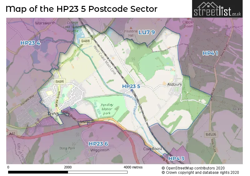
The HP23 5 Postcode shares a border with HP23 4 (TRING, Long Marston, Marsworth), HP23 6 (TRING, Wigginton, Buckland Common), HP4 1 (BERKHAMSTED, Little Gaddesden, Dagnall), HP4 3 (BERKHAMSTED, Northchurch, Dudswell) and LU7 9 (Pitstone, LEIGHTON BUZZARD, Hockliffe).
Map of the HP23 5 Postcode Sector
Explore the HP23 5 postcode sector by using our interactive map.
The sector is within the post town of TRING.
HP23 5 is a postcode sector within the HP23 postcode district which is within the HP Hemel Hempstead postcode area.
The Royal Mail delivery office for the HP23 5 postal sector is the Tring Delivery Office.
The area of the HP23 5 postcode sector is 5.53 square miles which is 14.34 square kilometres or 3,542.31 square acres.
Waterways within the HP23 5 postcode sector include the Grand Union Canal - Wendover Arm, Grand Union Canal.
Your support helps keep this site running!
If you enjoy using this website, consider buying me a coffee to help cover hosting costs.

| H | P | 2 | 3 | - | 5 | X | X |
| H | P | 2 | 3 | Space | 5 | Letter | Letter |
Official List of Streets
TRING (95 Streets)
Aldbury (14 Streets)
(11 Streets)
Bulbourne (2 Streets)
Northfield (1 Streets)
Cow Roast (1 Streets)
Unofficial Streets or Alternative Spellings
TRING
AKEMAN STREET ASH ROAD BUNSTRUX FRIARS WALKNorthchurch
NEW ROAD BRIDGE WAY BROOKFIELD CLOSE BUSHEL WHARF BYWAY CHAPPEL MEADOW EMMA ROTHSCHILD COURT GROVE LEYS KINGSLEY WAY LANGDALE GARDEN PATH NEWGROUND ROAD OLD JOES PATH RIDGE VIEW STONEY CROFT THE CEDARS THE LIMES TRING FORD ROADNew Ground
HEMP LANEDudswell
TRING ROADWeather Forecast for HP23 5
Weather Forecast for Tring
| Time Period | Icon | Description | Temperature | Rain Probability | Wind |
|---|---|---|---|---|---|
| 12:00 to 15:00 | Overcast | 5.0°C (feels like 2.0°C) | 9.00% | S 9 mph | |
| 15:00 to 18:00 | Overcast | 6.0°C (feels like 3.0°C) | 9.00% | SSE 9 mph | |
| 18:00 to 21:00 | Overcast | 5.0°C (feels like 2.0°C) | 8.00% | SSE 9 mph | |
| 21:00 to 00:00 | Cloudy | 3.0°C (feels like 0.0°C) | 5.00% | SSE 9 mph |
| Time Period | Icon | Description | Temperature | Rain Probability | Wind |
|---|---|---|---|---|---|
| 00:00 to 03:00 | Partly cloudy (night) | 2.0°C (feels like -1.0°C) | 1.00% | SSE 7 mph | |
| 03:00 to 06:00 | Partly cloudy (night) | 2.0°C (feels like -1.0°C) | 1.00% | SSE 7 mph | |
| 06:00 to 09:00 | Clear night | 1.0°C (feels like -2.0°C) | 1.00% | SSE 7 mph | |
| 09:00 to 12:00 | Sunny day | 2.0°C (feels like -2.0°C) | 0.00% | SSE 7 mph | |
| 12:00 to 15:00 | Sunny day | 5.0°C (feels like 2.0°C) | 0.00% | S 9 mph | |
| 15:00 to 18:00 | Sunny day | 6.0°C (feels like 3.0°C) | 0.00% | S 7 mph | |
| 18:00 to 21:00 | Clear night | 3.0°C (feels like 0.0°C) | 1.00% | S 4 mph | |
| 21:00 to 00:00 | Clear night | 2.0°C (feels like -1.0°C) | 1.00% | S 7 mph |
| Time Period | Icon | Description | Temperature | Rain Probability | Wind |
|---|---|---|---|---|---|
| 00:00 to 03:00 | Cloudy | 1.0°C (feels like -2.0°C) | 5.00% | SSW 7 mph | |
| 03:00 to 06:00 | Overcast | 2.0°C (feels like -2.0°C) | 9.00% | SSW 7 mph | |
| 06:00 to 09:00 | Overcast | 2.0°C (feels like -1.0°C) | 9.00% | SSW 7 mph | |
| 09:00 to 12:00 | Overcast | 3.0°C (feels like 0.0°C) | 9.00% | S 7 mph | |
| 12:00 to 15:00 | Cloudy | 6.0°C (feels like 3.0°C) | 6.00% | SSW 9 mph | |
| 15:00 to 18:00 | Cloudy | 7.0°C (feels like 4.0°C) | 5.00% | SSW 9 mph | |
| 18:00 to 21:00 | Partly cloudy (night) | 5.0°C (feels like 2.0°C) | 2.00% | S 9 mph | |
| 21:00 to 00:00 | Cloudy | 4.0°C (feels like 0.0°C) | 5.00% | S 11 mph |
| Time Period | Icon | Description | Temperature | Rain Probability | Wind |
|---|---|---|---|---|---|
| 00:00 to 03:00 | Cloudy | 4.0°C (feels like 1.0°C) | 6.00% | S 11 mph | |
| 03:00 to 06:00 | Partly cloudy (night) | 4.0°C (feels like 1.0°C) | 4.00% | S 11 mph | |
| 06:00 to 09:00 | Overcast | 4.0°C (feels like 1.0°C) | 8.00% | SSW 11 mph | |
| 09:00 to 12:00 | Overcast | 6.0°C (feels like 2.0°C) | 9.00% | SSW 11 mph | |
| 12:00 to 15:00 | Overcast | 8.0°C (feels like 5.0°C) | 10.00% | SSW 13 mph | |
| 15:00 to 18:00 | Overcast | 9.0°C (feels like 6.0°C) | 18.00% | SSW 13 mph | |
| 18:00 to 21:00 | Light rain | 8.0°C (feels like 5.0°C) | 50.00% | SSW 11 mph | |
| 21:00 to 00:00 | Partly cloudy (night) | 7.0°C (feels like 4.0°C) | 11.00% | WSW 9 mph |
| Time Period | Icon | Description | Temperature | Rain Probability | Wind |
|---|---|---|---|---|---|
| 00:00 to 03:00 | Clear night | 5.0°C (feels like 2.0°C) | 6.00% | W 9 mph | |
| 03:00 to 06:00 | Clear night | 4.0°C (feels like 1.0°C) | 3.00% | W 7 mph | |
| 06:00 to 09:00 | Clear night | 2.0°C (feels like -1.0°C) | 2.00% | WNW 7 mph | |
| 09:00 to 12:00 | Partly cloudy (day) | 3.0°C (feels like 0.0°C) | 2.00% | WNW 4 mph | |
| 12:00 to 15:00 | Cloudy | 6.0°C (feels like 4.0°C) | 4.00% | NW 7 mph | |
| 15:00 to 18:00 | Cloudy | 7.0°C (feels like 5.0°C) | 4.00% | NNW 4 mph | |
| 18:00 to 21:00 | Cloudy | 3.0°C (feels like 1.0°C) | 4.00% | NNW 4 mph | |
| 21:00 to 00:00 | Partly cloudy (night) | 2.0°C (feels like 0.0°C) | 2.00% | NNW 4 mph |
Schools and Places of Education Within the HP23 5 Postcode Sector
Aldbury Church of England Primary and Nursery School
Voluntary controlled school
Stocks Road, Tring, Hertfordshire, HP23 5RT
Head: Miss Jacqueline Moore
Ofsted Rating: Good
Inspection: 2023-05-17 (626 days ago)
Website: Visit Aldbury Church of England Primary and Nursery School Website
Phone: 01442851240
Number of Pupils: 107
Bishop Wood Church of England Junior School, Tring
Voluntary aided school
Frogmore Street, Tring, Hertfordshire, HP23 5AU
Head: Mr Gary Stanley
Ofsted Rating: Good
Inspection: 2023-03-22 (682 days ago)
Website: Visit Bishop Wood Church of England Junior School, Tring Website
Phone: 01442822024
Number of Pupils: 236
Grove Road Primary School
Academy converter
Grove Road, Tring, Hertfordshire, HP23 5PD
Head: Mrs Sharon Wilson
Ofsted Rating: Good
Inspection: 2022-04-27 (1011 days ago)
Website: Visit Grove Road Primary School Website
Phone: 01442822056
Number of Pupils: 457
Tring School
Academy converter
Mortimer Hill, Tring, Hertfordshire, HP23 5JD
Head: Mrs Sally Ambrose
Ofsted Rating: Good
Inspection: 2023-05-05 (638 days ago)
Website: Visit Tring School Website
Phone: 01442822303
Number of Pupils: 1540
House Prices in the HP23 5 Postcode Sector
| Type of Property | 2018 Average | 2018 Sales | 2017 Average | 2017 Sales | 2016 Average | 2016 Sales | 2015 Average | 2015 Sales |
|---|---|---|---|---|---|---|---|---|
| Detached | £760,278 | 27 | £800,583 | 30 | £780,394 | 43 | £792,457 | 50 |
| Semi-Detached | £522,874 | 33 | £543,974 | 19 | £563,264 | 32 | £422,237 | 43 |
| Terraced | £351,208 | 46 | £347,259 | 45 | £365,433 | 52 | £342,386 | 68 |
| Flats | £245,458 | 12 | £263,091 | 32 | £246,006 | 36 | £233,829 | 14 |
Important Postcodes HP23 5 in the Postcode Sector
HP23 5AU is the postcode for Bishop Wood Junior School, Frogmore Street, and Bishop Wood C of E Junior School, Frogmore Street
HP23 5DJ is the postcode for Dundale Primary & Nursery School, Bettys Lane, JUNIOR BUILDING, Dundale Primary & Nursery School, Bettys Lane, and INFANT BUILDING, Dundale Primary & Nursery School, Bettys Lane
HP23 5JD is the postcode for DESBOROUGH AND BELOE, Tring School, Mortimer Hill, MAIN BUILDING, Tring School, Mortimer Hill, Tring School, Mortimer Hill, SPORTS CENTRE, Tring School, Mortimer Hill, and NEVILLE, Tring School, Mortimer Hill
HP23 5JU is the postcode for Tring Sports Centre, Mortimer Hill
HP23 5PD is the postcode for Nursery and Reception, Grove Road Primary School, and Grove Road Primary School, Grove Road
HP23 5QY is the postcode for Pennyroyal, Station Road
HP23 5RT is the postcode for Aldbury Junior School, Stocks Road, Aldbury
| The HP23 5 Sector is within these Local Authorities |
|
|---|---|
| The HP23 5 Sector is within these Counties |
|
| The HP23 5 Sector is within these Water Company Areas |
|