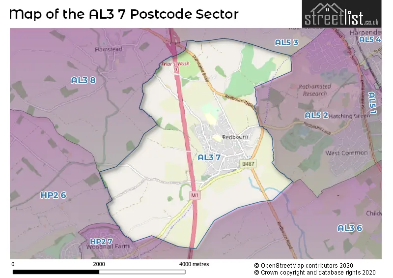
The AL3 7 postcode sector is within the county of Hertfordshire.
Did you know? According to the 2021 Census, the AL3 7 postcode sector is home to a bustling 5,346 residents!
Given that each sector allows for 400 unique postcode combinations. Letters C, I, K, M, O and V are not allowed in the last two letters of a postcode. With 183 postcodes already in use, this leaves 217 units available.
The AL3 7 postal code covers the settlement of Redbourn.
The AL3 7 Postcode shares a border with AL3 6 (ST. ALBANS, Childwickbury, Gorhambury), AL3 8 (Markyate, Flamstead), AL5 2 (HARPENDEN), HP2 6 (HEMEL HEMPSTEAD, Gaddesden Row, Bridens Camp), AL5 3 (HARPENDEN) and HP2 7 (HEMEL HEMPSTEAD, Hemel Hempstead Industrial Estate).
The sector is within the post town of ST. ALBANS.
AL3 7 is a postcode sector within the HP2 postcode district which is within the HP Hemel Hempstead postcode area.
The Royal Mail delivery office for the AL3 7 postal sector is the Hemel Hempstead Delivery Office.
The area of the AL3 7 postcode sector is 5.28 square miles which is 13.67 square kilometres or 3,376.90 square acres.
The AL3 7 postcode sector is crossed by the M1 motorway.
Waterways within the AL3 7 postcode sector include the River Ver.


Map of the AL3 7 Postcode Sector
Explore the AL3 7 postcode sector by using our free interactive map.
| A | L | 3 | - | 7 | X | X |
| A | L | 3 | Space | 7 | Letter | Letter |
Official List of Streets
Redbourn (77 Streets)
ST. ALBANS (1 Streets)
Unofficial Streets or Alternative Spellings
Flamstead
DUNSTABLE ROADHARPENDEN
KINSBOURNE GREEN LANEST. ALBANS
REDBOURN ROADHEMEL HEMPSTEAD
REDBOURN ROADWeather Forecast for AL3 7
Weather Forecast for Rothamsted
| Time Period | Icon | Description | Temperature | Rain Probability | Wind |
|---|---|---|---|---|---|
| 21:00 to 00:00 | Cloudy | 15.0°C (feels like 13.0°C) | 8.00% | NE 11 mph |
| Time Period | Icon | Description | Temperature | Rain Probability | Wind |
|---|---|---|---|---|---|
| 00:00 to 03:00 | Overcast | 14.0°C (feels like 12.0°C) | 9.00% | NE 9 mph | |
| 03:00 to 06:00 | Overcast | 13.0°C (feels like 12.0°C) | 10.00% | NNE 9 mph | |
| 06:00 to 09:00 | Overcast | 14.0°C (feels like 12.0°C) | 10.00% | NNE 9 mph | |
| 09:00 to 12:00 | Cloudy | 17.0°C (feels like 15.0°C) | 12.00% | NE 11 mph | |
| 12:00 to 15:00 | Thunder shower (day) | 20.0°C (feels like 18.0°C) | 60.00% | ENE 11 mph | |
| 15:00 to 18:00 | Sunny day | 21.0°C (feels like 19.0°C) | 10.00% | ENE 9 mph | |
| 18:00 to 21:00 | Clear night | 18.0°C (feels like 17.0°C) | 2.00% | ENE 9 mph | |
| 21:00 to 00:00 | Clear night | 14.0°C (feels like 13.0°C) | 0.00% | NE 9 mph |
| Time Period | Icon | Description | Temperature | Rain Probability | Wind |
|---|---|---|---|---|---|
| 00:00 to 03:00 | Clear night | 14.0°C (feels like 12.0°C) | 1.00% | NE 9 mph | |
| 03:00 to 06:00 | Clear night | 13.0°C (feels like 12.0°C) | 3.00% | NE 7 mph | |
| 06:00 to 09:00 | Sunny day | 13.0°C (feels like 12.0°C) | 6.00% | NE 7 mph | |
| 09:00 to 12:00 | Partly cloudy (day) | 17.0°C (feels like 16.0°C) | 4.00% | ENE 9 mph | |
| 12:00 to 15:00 | Partly cloudy (day) | 20.0°C (feels like 19.0°C) | 7.00% | E 9 mph | |
| 15:00 to 18:00 | Light rain shower (day) | 21.0°C (feels like 20.0°C) | 33.00% | E 9 mph | |
| 18:00 to 21:00 | Clear night | 18.0°C (feels like 18.0°C) | 5.00% | E 7 mph | |
| 21:00 to 00:00 | Partly cloudy (night) | 15.0°C (feels like 15.0°C) | 8.00% | ENE 7 mph |
| Time Period | Icon | Description | Temperature | Rain Probability | Wind |
|---|---|---|---|---|---|
| 00:00 to 03:00 | Cloudy | 14.0°C (feels like 13.0°C) | 7.00% | ENE 9 mph | |
| 03:00 to 06:00 | Cloudy | 14.0°C (feels like 13.0°C) | 13.00% | NE 7 mph | |
| 06:00 to 09:00 | Cloudy | 14.0°C (feels like 13.0°C) | 18.00% | ENE 9 mph | |
| 09:00 to 12:00 | Light rain shower (day) | 16.0°C (feels like 15.0°C) | 30.00% | ENE 11 mph | |
| 12:00 to 15:00 | Light rain shower (day) | 18.0°C (feels like 17.0°C) | 30.00% | E 11 mph | |
| 15:00 to 18:00 | Light rain shower (day) | 18.0°C (feels like 17.0°C) | 35.00% | E 9 mph | |
| 18:00 to 21:00 | Cloudy | 17.0°C (feels like 16.0°C) | 20.00% | E 7 mph | |
| 21:00 to 00:00 | Light rain shower (night) | 15.0°C (feels like 14.0°C) | 34.00% | E 7 mph |
| Time Period | Icon | Description | Temperature | Rain Probability | Wind |
|---|---|---|---|---|---|
| 00:00 to 03:00 | Overcast | 14.0°C (feels like 14.0°C) | 22.00% | E 7 mph | |
| 03:00 to 06:00 | Overcast | 13.0°C (feels like 13.0°C) | 21.00% | N 7 mph | |
| 06:00 to 09:00 | Mist | 13.0°C (feels like 12.0°C) | 24.00% | WSW 7 mph | |
| 09:00 to 12:00 | Overcast | 14.0°C (feels like 13.0°C) | 19.00% | WSW 9 mph | |
| 12:00 to 15:00 | Cloudy | 17.0°C (feels like 16.0°C) | 14.00% | WSW 9 mph | |
| 15:00 to 18:00 | Light rain shower (day) | 17.0°C (feels like 16.0°C) | 35.00% | SW 9 mph | |
| 18:00 to 21:00 | Light rain shower (night) | 15.0°C (feels like 14.0°C) | 32.00% | WSW 7 mph | |
| 21:00 to 00:00 | Light rain shower (night) | 13.0°C (feels like 12.0°C) | 29.00% | W 7 mph |
Schools and Places of Education Within the AL3 7 Postcode Sector
Redbourn Primary School
Community school
Long Cutt, St Albans, Hertfordshire, AL3 7EX
Head: Miss Emma Fenn
Ofsted Rating: Requires improvement
Inspection: 2022-10-13 (707 days ago)
Website: Visit Redbourn Primary School Website
Phone: 01582792341
Number of Pupils: 438
St Luke's School
Foundation special school
Crouch Hall Lane, St Albans, Hertfordshire, AL3 7ET
Head: Mr Stephen Hoult-Allen
Ofsted Rating: Good
Inspection: 2023-06-08 (469 days ago)
Website: Visit St Luke's School Website
Phone: 01582626727
Number of Pupils: 160
House Prices in the AL3 7 Postcode Sector
| Type of Property | 2018 Average | 2018 Sales | 2017 Average | 2017 Sales | 2016 Average | 2016 Sales | 2015 Average | 2015 Sales |
|---|---|---|---|---|---|---|---|---|
| Detached | £744,881 | 21 | £695,188 | 29 | £673,748 | 28 | £619,458 | 24 |
| Semi-Detached | £534,762 | 19 | £522,056 | 36 | £537,197 | 19 | £497,750 | 14 |
| Terraced | £446,925 | 20 | £415,889 | 18 | £421,332 | 29 | £363,968 | 33 |
| Flats | £244,278 | 16 | £271,812 | 13 | £343,278 | 18 | £271,850 | 7 |
Important Postcodes AL3 7 in the Postcode Sector
AL3 7BL is the postcode for Health Centre, 1, Hawkes Drive
AL3 7ET is the postcode for St. Luke's School, Crouch Hall Lane, MAIN BLOCK, St. Luke's School, Crouch Hall Lane, and MAIN BLOCK, ST LUKES SCHOOL, CROUCH HALL LANE
AL3 7EX is the postcode for Redbourn Primary School, Long Cutt, Redbourn Primary School (Upper School), Long Cutt, Redbourn, and Redbourn Lower School, Long Cutt, Redbourn
AL3 7LR is the postcode for Redbourn Parish Centre, The Park
AL3 7PP is the postcode for Redbourn Leisure Centre, 75 Dunstable Road, Redbourn, and Redbourn Leisure Centre, 75 Dunstable Road
| The AL3 7 Sector is within these Local Authorities |
|
|---|---|
| The AL3 7 Sector is within these Counties |
|
| The AL3 7 Sector is within these Water Company Areas |
|
Tourist Attractions within the AL3 7 Postcode Area
We found 1 visitor attractions within the HP2 postcode area
| Redbourn Village Museum |
|---|
| Museums & Art Galleries |
| Museum and / or Art Gallery |
| View Redbourn Village Museum on Google Maps |