A wide range of spatial data has been analysed to present this overview of the HP19 7 Postcode sector. If you would like anything added, please contact us.
The HP19 7 postcode sector is within the county of Buckinghamshire.
Did you know? According to the 2021 Census, the HP19 7 postcode sector is home to a bustling 6,792 residents!
Given that each sector allows for 400 unique postcode combinations. Letters C, I, K, M, O and V are not allowed in the last two letters of a postcode. With 146 postcodes already in use, this leaves 254 units available.
The HP19 7 postal code covers the settlement of AYLESBURY.
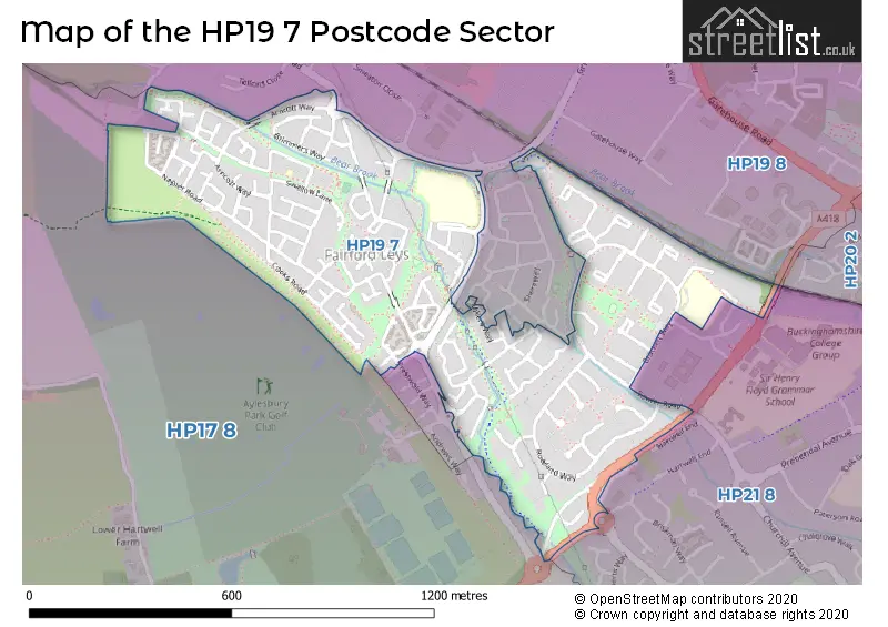
The HP19 7 Postcode shares a border with HP17 8 (Haddenham, Stone, Dinton), HP19 8 (AYLESBURY, Rabans Lane Industrial Area, Gatehouse Industrial Area), HP20 2 (AYLESBURY) and HP21 8 (AYLESBURY).
Map of the HP19 7 Postcode Sector
Explore the HP19 7 postcode sector by using our interactive map.
The sector is within the post town of AYLESBURY.
HP19 7 is a postcode sector within the HP19 postcode district which is within the HP Hemel Hempstead postcode area.
The Royal Mail delivery office for the HP19 7 postal sector is the Aylesbury Delivery Office.
The area of the HP19 7 postcode sector is 0.40 square miles which is 1.04 square kilometres or 256.91 square acres.
Your support helps keep this site running!
If you enjoy using this website, consider buying me a coffee to help cover hosting costs.

| H | P | 1 | 9 | - | 7 | X | X |
| H | P | 1 | 9 | Space | 7 | Letter | Letter |
Official List of Streets
AYLESBURY (96 Streets)
(2 Streets)
Unofficial Streets or Alternative Spellings
AYLESBURY
BRACKEN WAY CHURCHILL AVENUE COLDHARBOUR WAY GRIFFIN LANE HOMESTEAD PLACE LEITH ROAD OXFORD ROAD PRESTWOLD WAY THAME ROAD SOUTHRabans Lane Industrial Area
BRUNEL ROAD BRUNEL GATE CROMWELL MEWS GIBSON MEWS HEMP HILL SINGLETON WAY THAME VALLEY WALKHartwell
OXFORD ROADWeather Forecast for HP19 7
Weather Forecast for Aylesbury
| Time Period | Icon | Description | Temperature | Rain Probability | Wind |
|---|---|---|---|---|---|
| 15:00 to 18:00 | Sunny day | 7.0°C (feels like 4.0°C) | 0.00% | S 9 mph | |
| 18:00 to 21:00 | Clear night | 4.0°C (feels like 2.0°C) | 1.00% | SSW 4 mph | |
| 21:00 to 00:00 | Partly cloudy (night) | 2.0°C (feels like 0.0°C) | 1.00% | S 7 mph |
| Time Period | Icon | Description | Temperature | Rain Probability | Wind |
|---|---|---|---|---|---|
| 00:00 to 03:00 | Cloudy | 2.0°C (feels like -1.0°C) | 7.00% | SSW 7 mph | |
| 03:00 to 06:00 | Overcast | 3.0°C (feels like 0.0°C) | 9.00% | SSW 4 mph | |
| 06:00 to 09:00 | Overcast | 4.0°C (feels like 1.0°C) | 8.00% | SSW 7 mph | |
| 09:00 to 12:00 | Overcast | 5.0°C (feels like 2.0°C) | 9.00% | SSW 7 mph | |
| 12:00 to 15:00 | Overcast | 7.0°C (feels like 5.0°C) | 10.00% | SSW 9 mph | |
| 15:00 to 18:00 | Overcast | 8.0°C (feels like 6.0°C) | 10.00% | SSW 9 mph | |
| 18:00 to 21:00 | Cloudy | 7.0°C (feels like 4.0°C) | 5.00% | S 9 mph | |
| 21:00 to 00:00 | Cloudy | 6.0°C (feels like 3.0°C) | 4.00% | SSW 11 mph |
| Time Period | Icon | Description | Temperature | Rain Probability | Wind |
|---|---|---|---|---|---|
| 00:00 to 03:00 | Cloudy | 6.0°C (feels like 2.0°C) | 6.00% | SSW 11 mph | |
| 03:00 to 06:00 | Cloudy | 6.0°C (feels like 2.0°C) | 5.00% | SSW 11 mph | |
| 06:00 to 09:00 | Overcast | 6.0°C (feels like 3.0°C) | 8.00% | SSW 13 mph | |
| 09:00 to 12:00 | Overcast | 7.0°C (feels like 3.0°C) | 8.00% | SSW 13 mph | |
| 12:00 to 15:00 | Overcast | 9.0°C (feels like 6.0°C) | 10.00% | SSW 18 mph | |
| 15:00 to 18:00 | Overcast | 10.0°C (feels like 6.0°C) | 20.00% | SSW 16 mph | |
| 18:00 to 21:00 | Heavy rain | 9.0°C (feels like 6.0°C) | 83.00% | SW 13 mph | |
| 21:00 to 00:00 | Clear night | 7.0°C (feels like 4.0°C) | 15.00% | WSW 11 mph |
| Time Period | Icon | Description | Temperature | Rain Probability | Wind |
|---|---|---|---|---|---|
| 00:00 to 03:00 | Clear night | 6.0°C (feels like 2.0°C) | 1.00% | WSW 11 mph | |
| 03:00 to 06:00 | Clear night | 4.0°C (feels like 1.0°C) | 1.00% | W 9 mph | |
| 06:00 to 09:00 | Clear night | 3.0°C (feels like 0.0°C) | 1.00% | W 7 mph | |
| 09:00 to 12:00 | Partly cloudy (day) | 4.0°C (feels like 1.0°C) | 1.00% | W 7 mph | |
| 12:00 to 15:00 | Cloudy | 7.0°C (feels like 5.0°C) | 4.00% | WNW 7 mph | |
| 15:00 to 18:00 | Cloudy | 7.0°C (feels like 5.0°C) | 4.00% | NW 7 mph | |
| 18:00 to 21:00 | Partly cloudy (night) | 4.0°C (feels like 2.0°C) | 1.00% | NW 4 mph | |
| 21:00 to 00:00 | Clear night | 2.0°C (feels like 0.0°C) | 1.00% | NNW 4 mph |
| Time Period | Icon | Description | Temperature | Rain Probability | Wind |
|---|---|---|---|---|---|
| 00:00 to 03:00 | Clear night | 1.0°C (feels like -1.0°C) | 1.00% | N 4 mph | |
| 03:00 to 06:00 | Clear night | 0.0°C (feels like -2.0°C) | 2.00% | NNE 4 mph | |
| 06:00 to 09:00 | Clear night | 0.0°C (feels like -3.0°C) | 2.00% | NNE 4 mph | |
| 09:00 to 12:00 | Sunny day | 2.0°C (feels like -1.0°C) | 2.00% | NE 7 mph | |
| 12:00 to 15:00 | Sunny day | 6.0°C (feels like 4.0°C) | 1.00% | ENE 7 mph | |
| 15:00 to 18:00 | Sunny day | 7.0°C (feels like 5.0°C) | 1.00% | ENE 9 mph | |
| 18:00 to 21:00 | Clear night | 4.0°C (feels like 1.0°C) | 1.00% | NE 7 mph | |
| 21:00 to 00:00 | Clear night | 3.0°C (feels like -1.0°C) | 1.00% | ENE 7 mph |
Schools and Places of Education Within the HP19 7 Postcode Sector
Bearbrook Combined School
Academy converter
Fowler Road, Aylesbury, Buckinghamshire, HP19 7QP
Head: Mr Marcus Faulkner
Ofsted Rating: Good
Inspection: 2023-12-14 (416 days ago)
Website: Visit Bearbrook Combined School Website
Phone: 01296488331
Number of Pupils: 457
Benjamin College
Other independent special school
4 Wren Path, AYLESBURY, Buckinghamshire, HP19 7AR
Head: Mrs Anne Hanson
Ofsted Rating: Requires improvement
Inspection: 2022-11-10 (815 days ago)
Website: Visit Benjamin College Website
Phone: 08000921312
Number of Pupils: 12
House Prices in the HP19 7 Postcode Sector
| Type of Property | 2018 Average | 2018 Sales | 2017 Average | 2017 Sales | 2016 Average | 2016 Sales | 2015 Average | 2015 Sales |
|---|---|---|---|---|---|---|---|---|
| Detached | £394,604 | 24 | £388,656 | 25 | £353,015 | 24 | £330,809 | 29 |
| Semi-Detached | £298,321 | 35 | £299,750 | 50 | £275,931 | 40 | £249,989 | 37 |
| Terraced | £264,576 | 57 | £264,151 | 54 | £258,662 | 72 | £221,395 | 75 |
| Flats | £187,764 | 32 | £185,674 | 40 | £179,361 | 48 | £145,749 | 58 |
Important Postcodes HP19 7 in the Postcode Sector
HP19 7QG is the postcode for Prebendal Farm Community Centre, Fowler Road
HP19 7QP is the postcode for Bearbrook Combined School, Fowler Road, and Bearbrook Cp School, Fowler Road
HP19 7WF is the postcode for ST MARYS CHURCH OF ENGLAND SCHOOL, KEEN CLOSE, COLDHARBOUR, St. Marys C of E School, Keen Close, and EARLY YEARS BUILDING, St. Marys C of E School, Keen Close
| The HP19 7 Sector is within these Local Authorities |
|
|---|---|
| The HP19 7 Sector is within these Counties |
|
| The HP19 7 Sector is within these Water Company Areas |
|