
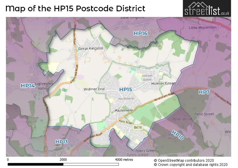
Map of the HP15 Postcode District
Explore the postcode district by using our interactive map.
Circles represent recorded crime; the larger the circle, the higher the crime rates.
Your support helps keep this site running!
If you enjoy using this website, consider buying me a coffee to help cover hosting costs.
Where is the HP15 District?
To give you an idea where the district is located we have created the following table showing nearby towns.
Nearest Towns to HP15
| Town | Distance (miles) | Direction |
|---|---|---|
| High Wycombe | 2.85 | SSW |
| Amersham | 4.67 | ENE |
| Beaconsfield | 4.73 | SE |
| Chesham | 5.13 | ENE |
| Princes Risborough | 6.58 | NW |
| Marlow | 6.90 | SSW |
| Wendover | 6.93 | N |
| Chorleywood | 8.32 | E |
| Gerrards Cross | 8.67 | SE |
| Berkhamsted | 9.15 | NE |
| Tring | 9.25 | NNE |
| Maidenhead | 9.75 | S |
| Rickmansworth | 10.68 | E |
| Aylesbury | 11.39 | NNW |
| Slough | 11.91 | SSE |
| Henley-on-Thames | 11.97 | SW |
| Hemel Hempstead | 12.07 | ENE |
| Watlington | 12.60 | W |
| Thame | 12.81 | WNW |
| Eton | 12.85 | SSE |
The post town for this district is HIGH WYCOMBE.
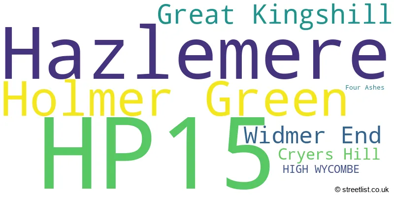
Postcode Information for District HP15 (Total Geographical Postcodes: 458)
| Location | Post Town | Sector | Number of Postcodes |
|---|---|---|---|
| Hazlemere | HIGH WYCOMBE | HP15 7 | 237 |
| Holmer Green | HIGH WYCOMBE | HP15 6 | 105 |
| Great Kingshill | HIGH WYCOMBE | HP15 6 | 52 |
| Widmer End | HIGH WYCOMBE | HP15 6 | 43 |
| Cryers Hill | HIGH WYCOMBE | HP15 6 | 15 |
| HIGH WYCOMBE | HIGH WYCOMBE | HP15 6 | 3 |
| Four Ashes | HIGH WYCOMBE | HP15 6 | 2 |
| HIGH WYCOMBE | HIGH WYCOMBE | HP15 7 | 1 |
Retail and Shopping in HP15
Street
Town
Locality
Number of Shops
Central Postcode
View on Google Maps
PARK PARADE CENTRE
HIGH WYCOMBE
HAZLEMERE
18
HP15 7AA
View on Google Maps
PENN ROAD
HIGH WYCOMBE
HAZLEMERE
10
HP15 7LN
View on Google Maps
AMERSHAM ROAD
HIGH WYCOMBE
HAZLEMERE
8
HP15 7QA
View on Google Maps
POND APPROACH
HIGH WYCOMBE
HOLMER GREEN
7
HP15 6RW
View on Google Maps
| Street | Town | Locality | Number of Shops | Central Postcode | View on Google Maps |
|---|---|---|---|---|---|
| PARK PARADE CENTRE | HIGH WYCOMBE | HAZLEMERE | 18 | HP15 7AA | View on Google Maps |
| PENN ROAD | HIGH WYCOMBE | HAZLEMERE | 10 | HP15 7LN | View on Google Maps |
| AMERSHAM ROAD | HIGH WYCOMBE | HAZLEMERE | 8 | HP15 7QA | View on Google Maps |
| POND APPROACH | HIGH WYCOMBE | HOLMER GREEN | 7 | HP15 6RW | View on Google Maps |
The primary settlement in the HP15 postcode district is Holmer Green, which is located in the county of Buckinghamshire in England. Other significant settlements in this postcode district include Widmer End, Great Kingshill, and Cryers Hill. The most significant post town in the HP15 postcode district is High Wycombe.
When it comes to local government, postal geography often disregards political borders. However, this district intersects the following councils: the district mostly encompasses the Buckinghamshire area with a total of 426 postal codes.
The largest settlement in the HP15 postal code is Hazlemere followed by Holmer Green, and Great Kingshill.
The HP15 Postcode shares a border with HP10 (Wooburn Green, Flackwell Heath, Penn), HP13 (HIGH WYCOMBE, Downley), HP14 (Stokenchurch, Lane End, Walters Ash), HP7 (AMERSHAM, Coleshill, Winchmore Hill) and HP16 (Prestwood, GREAT MISSENDEN, Little Kingshill).


Dentists in the HP15 District
| # | Name | Address | Type | Contact |
|---|---|---|---|---|
| 1 | The Hazlemere Dental Practice | 1 HOLMER GREEN ROAD , HAZLEMERE , HIGH WYCOMBE , BUCKINGHAMSHIRE , HP15 7BB | GENERAL DENTAL PRACTICE |
Doctors in the HP15 District
| # | Name | Address | Type | Contact |
|---|---|---|---|---|
| 1 | Dr Ec Bray | , 35 BROWNS ROAD , HOLMER GREEN , HIGH WYCOMBE , BUCKINGHAMSHIRE , HP15 6RZ | BRANCH SURGERY | |
| 2 | Highfield Surgery | , HAZLEMERE , HIGH WYCOMBE , BUCKINGHAMSHIRE , HP15 7UW | GP PRACTICE | |
| 3 | Reidy Rn | , 2A ROBERTS RIDE , HAZLEMERE , HIGH WYCOMBE , BUCKINGHAMSHIRE , HP15 7AD | BRANCH SURGERY |
Chemists in the HP15 District
| # | Name | Address | Type | Contact |
|---|---|---|---|---|
| 1 | Rowlands Pharmacy | 2 MARKET PARADE , HAZLEMERE , HIGH WYCOMBE , BUCKINGHAMSHIRE , HP15 7LQ | PHARMACY | |
| 2 | Boots | 9-11 PARK PARADE CENTRE , HAZLEMERE , HIGH WYCOMBE , BUCKINGHAMSHIRE , HP15 7AA | PHARMACY | |
| 3 | Landsdales Pharmacy & Clinics | 9 TURNERS PLACE , HOLMER GREEN , HIGH WYCOMBE , BUCKINGHAMSHIRE , HP15 6RN | PHARMACY |
Opticians in the HP15 District
| # | Name | Address | Type | Contact |
|---|---|---|---|---|
| 1 | W J KEPETZIS OPTOMETRISTS | 26 EASTERN DENE , HAZLEMERE , HIGH WYCOMBE , BUCKINGHAMSHIRE , HP15 7BS | OPTICAL SITE |
Schools in the Sector
Widmer End Community Combined School
Phase: Primary
Address: Estcourt Drive , Widmer End , High Wycombe
Postcode: HP15 6AH
Headteacher: Mrs Gemma Hillier (Headteacher)
Ofsted Rating: Good
Great Kingshill Church of England Combined School
Phase: Primary
Address: Cryers Hill Road , Cryers Hill Great Kingshill , High Wycombe
Postcode: HP15 6JP
Headteacher: Miss Joanne Garlick (Headteacher)
Ofsted Rating: Good
Great Kingshill Church of England Combined School
Phase: Primary
Address: Cryers Hill Road , Cryers Hill , High Wycombe
Postcode: HP15 6JP
Headteacher: Mrs Suzanne Best (Headteacher)
Ofsted Rating: Good
Holmer Green Senior School
Phase: Secondary
Address: Parish Piece , Holmer Green , High Wycombe
Postcode: HP15 6SP
Headteacher: Mr Edward Hillyard (Headteacher)
Ofsted Rating: Good
Holmer Green Junior School
Phase: Primary
Address: The Common , Holmer Green , High Wycombe
Postcode: HP15 6TD
Headteacher: Mr Robin Cusdin (Headteacher)
Ofsted Rating: Good
Holmer Green First School and Pre-School
Phase: Primary
Address: Watchet Lane , Holmer Green , High Wycombe
Postcode: HP15 6UG
Headteacher: Mrs Gillian Jones (Headteacher)
Ofsted Rating: Good
Cedar Park School & Nursery
Phase: Primary
Address: Cedar Avenue , Hazlemere , High Wycombe
Postcode: HP15 7EF
Headteacher: Mr Luke Redman (Headteacher)
Ofsted Rating: Good
Manor Farm Community Infant School
Phase: Primary
Address: Rose Avenue , Hazlemere , High Wycombe
Postcode: HP15 7PH
Headteacher: Janice Woodhead (Headteacher)
Ofsted Rating: Good
Manor Farm Community Junior School
Phase: Primary
Address: Rose Avenue , Hazlemere , Manor Farm Community Junior School , HIGH WYCOMBE
Postcode: HP15 7PH
Headteacher: Mr David Compton (Headteacher)
Ofsted Rating: Serious Weaknesses
Hazlemere Church of England Combined School
Phase: Primary
Address: Amersham Road , Hazlemere , High Wycombe
Postcode: HP15 7PZ
Headteacher: Mr Brian Daniels (Headteacher)
Ofsted Rating: Good
Sir William Ramsay School
Phase: Secondary
Address: Rose Avenue , Hazlemere , High Wycombe
Postcode: HP15 7UB
Headteacher: Mr Garret Fay (Headteacher)
Ofsted Rating: Serious Weaknesses
Stations in the Sector
No stations found in this postcode district.
Accessable Motorway Junctions
M40 J4
Average Driving Time from within the district: 9.03
Average Driving Distance: 4.55
Number of Postcodes that can access the Motorway Junction: 424
M40 J3
Average Driving Time from within the district: 12.63
Average Driving Distance: 5.77
Number of Postcodes that can access the Motorway Junction: 424
A404(M) J9
Average Driving Time from within the district: 13.16
Average Driving Distance: 10.31
Number of Postcodes that can access the Motorway Junction: 29
M40 J2
Average Driving Time from within the district: 13.24
Average Driving Distance: 8.51
Number of Postcodes that can access the Motorway Junction: 424
M40 J5
Average Driving Time from within the district: 15.93
Average Driving Distance: 11.85
Number of Postcodes that can access the Motorway Junction: 309
M25 J18
Average Driving Time from within the district: 17.14
Average Driving Distance: 10.52
Number of Postcodes that can access the Motorway Junction: 113
M40 J6
Average Driving Time from within the district: 18.87
Average Driving Distance: 15.28
Number of Postcodes that can access the Motorway Junction: 33
M25 J17
Average Driving Time from within the district: 19.70
Average Driving Distance: 12.60
Number of Postcodes that can access the Motorway Junction: 364
Weather Forecast for High Wycombe
| Time Period | Icon | Description | Temperature | Rain Probability | Wind |
|---|---|---|---|---|---|
| 21:00 to 00:00 | Cloudy | 3.0°C (feels like 2.0°C) | 6.00% | S 4 mph |
| Time Period | Icon | Description | Temperature | Rain Probability | Wind |
|---|---|---|---|---|---|
| 00:00 to 03:00 | Overcast | 3.0°C (feels like 1.0°C) | 9.00% | SSW 4 mph | |
| 03:00 to 06:00 | Fog | 2.0°C (feels like 0.0°C) | 16.00% | S 4 mph | |
| 06:00 to 09:00 | Fog | 1.0°C (feels like -1.0°C) | 17.00% | SSE 4 mph | |
| 09:00 to 12:00 | Fog | 1.0°C (feels like -1.0°C) | 18.00% | SE 4 mph | |
| 12:00 to 15:00 | Overcast | 3.0°C (feels like 0.0°C) | 11.00% | SSE 4 mph | |
| 15:00 to 18:00 | Overcast | 3.0°C (feels like 1.0°C) | 10.00% | SE 4 mph | |
| 18:00 to 21:00 | Cloudy | 2.0°C (feels like 0.0°C) | 6.00% | ESE 4 mph | |
| 21:00 to 00:00 | Cloudy | 2.0°C (feels like 0.0°C) | 7.00% | ESE 4 mph |
| Time Period | Icon | Description | Temperature | Rain Probability | Wind |
|---|---|---|---|---|---|
| 00:00 to 03:00 | Cloudy | 2.0°C (feels like -1.0°C) | 7.00% | ESE 4 mph | |
| 03:00 to 06:00 | Cloudy | 1.0°C (feels like -1.0°C) | 9.00% | E 4 mph | |
| 06:00 to 09:00 | Cloudy | 1.0°C (feels like -1.0°C) | 10.00% | E 4 mph | |
| 09:00 to 12:00 | Mist | 2.0°C (feels like -1.0°C) | 18.00% | ENE 4 mph | |
| 12:00 to 15:00 | Overcast | 3.0°C (feels like 1.0°C) | 12.00% | ENE 4 mph | |
| 15:00 to 18:00 | Overcast | 4.0°C (feels like 2.0°C) | 16.00% | ENE 7 mph | |
| 18:00 to 21:00 | Overcast | 4.0°C (feels like 1.0°C) | 22.00% | ENE 7 mph | |
| 21:00 to 00:00 | Overcast | 3.0°C (feels like 1.0°C) | 20.00% | ENE 7 mph |
| Time Period | Icon | Description | Temperature | Rain Probability | Wind |
|---|---|---|---|---|---|
| 00:00 to 03:00 | Light rain | 3.0°C (feels like 1.0°C) | 48.00% | NE 7 mph | |
| 03:00 to 06:00 | Mist | 3.0°C (feels like 0.0°C) | 29.00% | NNW 7 mph | |
| 06:00 to 09:00 | Overcast | 3.0°C (feels like 0.0°C) | 23.00% | NW 7 mph | |
| 09:00 to 12:00 | Overcast | 3.0°C (feels like 0.0°C) | 20.00% | WSW 7 mph | |
| 12:00 to 15:00 | Overcast | 5.0°C (feels like 1.0°C) | 15.00% | WSW 9 mph | |
| 15:00 to 18:00 | Overcast | 6.0°C (feels like 3.0°C) | 16.00% | WSW 9 mph | |
| 18:00 to 21:00 | Cloudy | 5.0°C (feels like 2.0°C) | 14.00% | SW 7 mph | |
| 21:00 to 00:00 | Cloudy | 4.0°C (feels like 1.0°C) | 13.00% | SW 7 mph |
| Postal Sector | Delivery Office |
|---|---|
| HP15 6 | Hazlemere Delivery Office |
| HP15 7 | Hazlemere Delivery Office |
| H | P | 1 | 5 | - | X | X | X |
| H | P | 1 | 5 | Space | Numeric | Letter | Letter |
Street List for the HP15 District
Current Monthly Rental Prices
| # Bedrooms | Min Price | Max Price | Avg Price |
|---|---|---|---|
| £800 | £800 | £800 | |
| 1 | £950 | £1,395 | £1,173 |
| 2 | £1,700 | £2,400 | £1,858 |
| 3 | £1,800 | £1,800 | £1,800 |
| 4 | £1,750 | £2,400 | £2,150 |
Current House Prices
| # Bedrooms | Min Price | Max Price | Avg Price |
|---|---|---|---|
| £25,000 | £475,000 | £250,000 | |
| 1 | £154,950 | £335,000 | £239,681 |
| 2 | £255,000 | £650,000 | £412,997 |
| 3 | £400,000 | £750,000 | £526,327 |
| 4 | £499,950 | £1,500,000 | £763,019 |
| 5 | £539,950 | £1,350,000 | £1,073,742 |
| 6 | £1,100,000 | £1,599,950 | £1,384,980 |
Estate Agents
| Logo | Name | Brand Name | Address | Contact Number |
|---|---|---|---|---|
 | Hazlemere | Wye Residential | 3 Market Parade, Hazlemere, HP15 7LQ | 01494 341325 |
 | Hazlemere | JNP | Old Bank House Amersham Road Hazlemere HP15 7PU | 01494 419362 |
 | Amersham | Kingshills Estate Agents South Buckinghamshire | Comet Studios De Havilland Court Penn Street Amersham HP7 0PX | 01494 939868 |
 | Hazlemere | Keegan White | 1 Penn Road, Hazlemere, HP15 7LN | 01494 341061 |
 | Hazlemere | Hurst Estate Agents | 25 Park Parade Centre, Hazlemere, HP15 7AA | 01494 328857 |
Yearly House Price Averages for the District
| Type of Property | 2018 Average | 2018 Sales | 2017 Average | 2017 Sales | 2016 Average | 2016 Sales | 2015 Average | 2015 Sales |
|---|---|---|---|---|---|---|---|---|
| Detached | £647,373 | 91 | £650,876 | 100 | £629,463 | 90 | £533,001 | 99 |
| Semi-Detached | £438,083 | 72 | £454,026 | 82 | £430,510 | 81 | £382,942 | 91 |
| Terraced | £368,139 | 38 | £377,923 | 46 | £345,414 | 55 | £312,559 | 53 |
| Flats | £305,804 | 70 | £266,598 | 25 | £259,290 | 26 | £258,338 | 38 |