A wide range of spatial data has been analysed to present this overview of the HA8 5 Postcode sector. If you would like anything added, please contact us.
The HA8 5 postcode sector is within the county of Greater London.
Did you know? According to the 2021 Census, the HA8 5 postcode sector is home to a bustling 14,009 residents!
Given that each sector allows for 400 unique postcode combinations. Letters C, I, K, M, O and V are not allowed in the last two letters of a postcode. With 206 postcodes already in use, this leaves 194 units available.
The HA8 5 postal code covers the settlement of EDGWARE .
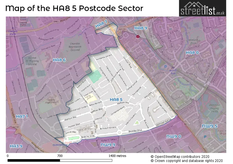
The HA8 5 Postcode shares a border with NW9 0 (LONDON , KINGSBURY ), NW9 5 (COLINDALE , GRAHAME PARK SOUTH SECTION ), NW9 9 (LONDON , KINGSBURY ), HA8 7 (EDGWARE , THE HALE ), HA7 1 (STANMORE ), HA8 0 (EDGWARE , BURNT OAK ), HA8 6 (EDGWARE ) and HA8 9 (EDGWARE , DEANS LANE TO LYNDHURST AVENUE ).
Map of the HA8 5 Postcode Sector
Explore the HA8 5 postcode sector by using our interactive map.
The sector is within the post town of EDGWARE.
HA8 5 is a postcode sector within the HA8 postcode district which is within the HA Harrow postcode area.
The Royal Mail delivery office for the HA8 5 postal sector is the Edgware Delivery Office.
The area of the HA8 5 postcode sector is 0.51 square miles which is 1.31 square kilometres or 323.88 square acres.
Waterways within the HA8 5 postcode sector include the Edgware Brook.
Your support helps keep this site running!
If you enjoy using this website, consider buying me a coffee to help cover hosting costs.

| H | A | 8 | - | 5 | X | X |
| H | A | 8 | Space | 5 | Letter | Letter |
Official List of Streets
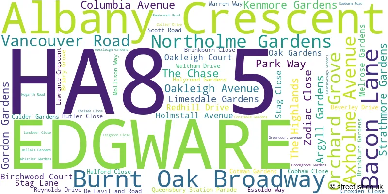
EDGWARE (61 Streets)
(2 Streets)
Unofficial Streets or Alternative Spellings
Weather Forecast for HA8 5
Weather Forecast for Wembley Arena
| Time Period | Icon | Description | Temperature | Rain Probability | Wind |
|---|---|---|---|---|---|
| 12:00 to 15:00 | Overcast | 7.0°C (feels like 5.0°C) | 11.00% | S 4 mph | |
| 15:00 to 18:00 | Overcast | 8.0°C (feels like 5.0°C) | 44.00% | SSW 9 mph | |
| 18:00 to 21:00 | Cloudy | 7.0°C (feels like 5.0°C) | 5.00% | SSW 7 mph | |
| 21:00 to 00:00 | Overcast | 6.0°C (feels like 4.0°C) | 10.00% | SSW 7 mph |
| Time Period | Icon | Description | Temperature | Rain Probability | Wind |
|---|---|---|---|---|---|
| 00:00 to 03:00 | Overcast | 7.0°C (feels like 4.0°C) | 9.00% | SSW 9 mph | |
| 03:00 to 06:00 | Cloudy | 7.0°C (feels like 5.0°C) | 8.00% | SSW 9 mph | |
| 06:00 to 09:00 | Cloudy | 7.0°C (feels like 4.0°C) | 4.00% | SSW 11 mph | |
| 09:00 to 12:00 | Cloudy | 7.0°C (feels like 5.0°C) | 5.00% | SSW 11 mph | |
| 12:00 to 15:00 | Cloudy | 9.0°C (feels like 6.0°C) | 8.00% | SSW 13 mph | |
| 15:00 to 18:00 | Overcast | 10.0°C (feels like 7.0°C) | 14.00% | SSW 13 mph | |
| 18:00 to 21:00 | Heavy rain | 9.0°C (feels like 7.0°C) | 79.00% | SSW 13 mph | |
| 21:00 to 00:00 | Partly cloudy (night) | 9.0°C (feels like 6.0°C) | 10.00% | WSW 9 mph |
| Time Period | Icon | Description | Temperature | Rain Probability | Wind |
|---|---|---|---|---|---|
| 00:00 to 03:00 | Clear night | 7.0°C (feels like 4.0°C) | 1.00% | WSW 7 mph | |
| 03:00 to 06:00 | Clear night | 5.0°C (feels like 3.0°C) | 0.00% | WSW 7 mph | |
| 06:00 to 09:00 | Clear night | 4.0°C (feels like 2.0°C) | 0.00% | WSW 4 mph | |
| 09:00 to 12:00 | Cloudy | 4.0°C (feels like 2.0°C) | 4.00% | WSW 4 mph | |
| 12:00 to 15:00 | Cloudy | 7.0°C (feels like 6.0°C) | 4.00% | W 4 mph | |
| 15:00 to 18:00 | Cloudy | 9.0°C (feels like 7.0°C) | 5.00% | NW 4 mph | |
| 18:00 to 21:00 | Cloudy | 6.0°C (feels like 6.0°C) | 5.00% | NNW 4 mph | |
| 21:00 to 00:00 | Partly cloudy (night) | 5.0°C (feels like 4.0°C) | 1.00% | N 4 mph |
| Time Period | Icon | Description | Temperature | Rain Probability | Wind |
|---|---|---|---|---|---|
| 00:00 to 03:00 | Partly cloudy (night) | 4.0°C (feels like 2.0°C) | 1.00% | NNE 4 mph | |
| 03:00 to 06:00 | Clear night | 3.0°C (feels like 1.0°C) | 1.00% | NNE 4 mph | |
| 06:00 to 09:00 | Clear night | 2.0°C (feels like 0.0°C) | 0.00% | NE 4 mph | |
| 09:00 to 12:00 | Sunny day | 2.0°C (feels like 0.0°C) | 1.00% | NE 4 mph | |
| 12:00 to 15:00 | Sunny day | 6.0°C (feels like 4.0°C) | 1.00% | NE 7 mph | |
| 15:00 to 18:00 | Sunny day | 8.0°C (feels like 6.0°C) | 2.00% | ENE 9 mph | |
| 18:00 to 21:00 | Clear night | 6.0°C (feels like 4.0°C) | 1.00% | NE 7 mph | |
| 21:00 to 00:00 | Clear night | 4.0°C (feels like 2.0°C) | 1.00% | NE 7 mph |
| Time Period | Icon | Description | Temperature | Rain Probability | Wind |
|---|---|---|---|---|---|
| 00:00 to 03:00 | Clear night | 3.0°C (feels like 1.0°C) | 1.00% | NE 7 mph | |
| 03:00 to 06:00 | Cloudy | 3.0°C (feels like 0.0°C) | 5.00% | NE 7 mph | |
| 06:00 to 09:00 | Cloudy | 3.0°C (feels like 0.0°C) | 5.00% | NE 7 mph | |
| 09:00 to 12:00 | Overcast | 3.0°C (feels like 0.0°C) | 9.00% | NE 9 mph | |
| 12:00 to 15:00 | Partly cloudy (day) | 5.0°C (feels like 2.0°C) | 3.00% | NE 9 mph | |
| 15:00 to 18:00 | Partly cloudy (day) | 6.0°C (feels like 3.0°C) | 3.00% | NE 9 mph | |
| 18:00 to 21:00 | Clear night | 5.0°C (feels like 2.0°C) | 2.00% | NE 9 mph | |
| 21:00 to 00:00 | Cloudy | 4.0°C (feels like 1.0°C) | 5.00% | NE 7 mph |
Schools and Places of Education Within the HA8 5 Postcode Sector
Stag Lane Primary School
Community school
Collier Drive, Edgware, Middlesex, HA8 5RU
Head: Mrs Nina Will
Ofsted Rating: Good
Inspection: 2018-12-05 (2252 days ago)
Website: Visit Stag Lane Primary School Website
Phone: 02089521475
Number of Pupils: 855
House Prices in the HA8 5 Postcode Sector
| Type of Property | 2018 Average | 2018 Sales | 2017 Average | 2017 Sales | 2016 Average | 2016 Sales | 2015 Average | 2015 Sales |
|---|---|---|---|---|---|---|---|---|
| Detached | £746,000 | 2 | £0 | 0 | £562,500 | 2 | £563,333 | 3 |
| Semi-Detached | £521,842 | 36 | £525,303 | 36 | £533,652 | 26 | £452,294 | 44 |
| Terraced | £483,393 | 14 | £455,739 | 23 | £395,389 | 18 | £421,783 | 30 |
| Flats | £300,609 | 16 | £287,643 | 21 | £310,403 | 58 | £295,350 | 161 |
Important Postcodes HA8 5 in the Postcode Sector
HA8 5RU is the postcode for Stag Lane School, Collier Drive
| The HA8 5 Sector is within these Local Authorities |
|
|---|---|
| The HA8 5 Sector is within these Counties |
|
| The HA8 5 Sector is within these Water Company Areas |
|