A wide range of spatial data has been analysed to present this overview of the HA7 4 Postcode sector. If you would like anything added, please contact us.
The HA7 4 postcode sector stands on the Greater London and Hertfordshire border.
Did you know? According to the 2021 Census, the HA7 4 postcode sector is home to a bustling 9,838 residents!
Given that each sector allows for 400 unique postcode combinations. Letters C, I, K, M, O and V are not allowed in the last two letters of a postcode. With 254 postcodes already in use, this leaves 146 units available.
The HA7 4 postal code covers the settlement of STANMORE .
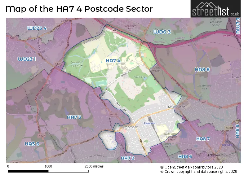
The HA7 4 Postcode shares a border with WD23 4 (BUSHEY , BUSHEY HEATH ), HA7 3 (STANMORE , HARROW WEALD ), HA8 7 (EDGWARE , THE HALE ), WD6 3 (ELSTREE ), WD23 1 (BUSHEY , BUSHEY HEATH ), HA7 2 (STANMORE ), HA8 6 (EDGWARE ) and HA8 8 (EDGWARE , STONEGROVE AND SPUR ROAD ESTATE ).
Map of the HA7 4 Postcode Sector
Explore the HA7 4 postcode sector by using our interactive map.
The sector is within the post town of STANMORE.
HA7 4 is a postcode sector within the HA7 postcode district which is within the HA Harrow postcode area.
The Royal Mail delivery office for the HA7 4 postal sector is the Stanmore Delivery Office.
The area of the HA7 4 postcode sector is 1.95 square miles which is 5.04 square kilometres or 1,245.40 square acres.
The HA7 4 postcode sector is crossed by the M1 motorway.
Your support helps keep this site running!
If you enjoy using this website, consider buying me a coffee to help cover hosting costs.


| H | A | 7 | - | 4 | X | X |
| H | A | 7 | Space | 4 | Letter | Letter |
Official List of Streets
STANMORE (98 Streets)
(5 Streets)
Unofficial Streets or Alternative Spellings
EDGWARE,
HOWBERRY ROAD CHATSWORTH COURT EDGWARE WAY (WATFORD BY-PASS) ELLIOTT ROAD GROVE FARM LANE HARROW FP04 HORSE RIDE LADY ALESFORD AVENUE LONG TRAIL WATFORD BY-PASSSTANMORE
DOUGLAS CLOSE EATON CLOSE GREEN LANE LANSDOWNE ROAD LITTLE COMMON OLD CHURCH LANE PRIORY DRIVE STANMORE HILL THE COMMONEDGWARE
PIPERS GREEN LANE WYCHWOOD AVENUEHARROW,
UXBRIDGE ROADBushey Heath
HEATHBOURNE ROADWeather Forecast for HA7 4
Weather Forecast for Bushey
| Time Period | Icon | Description | Temperature | Rain Probability | Wind |
|---|---|---|---|---|---|
| 00:00 to 03:00 | Partly cloudy (night) | 3.0°C (feels like 0.0°C) | 1.00% | SSE 7 mph | |
| 03:00 to 06:00 | Clear night | 2.0°C (feels like 0.0°C) | 0.00% | SSE 7 mph | |
| 06:00 to 09:00 | Clear night | 2.0°C (feels like -1.0°C) | 0.00% | SE 7 mph | |
| 09:00 to 12:00 | Sunny day | 2.0°C (feels like -1.0°C) | 0.00% | SE 7 mph | |
| 12:00 to 15:00 | Sunny day | 5.0°C (feels like 3.0°C) | 0.00% | S 7 mph | |
| 15:00 to 18:00 | Sunny day | 6.0°C (feels like 4.0°C) | 0.00% | S 7 mph | |
| 18:00 to 21:00 | Clear night | 4.0°C (feels like 2.0°C) | 0.00% | SSW 4 mph | |
| 21:00 to 00:00 | Clear night | 2.0°C (feels like 0.0°C) | 1.00% | S 4 mph |
| Time Period | Icon | Description | Temperature | Rain Probability | Wind |
|---|---|---|---|---|---|
| 00:00 to 03:00 | Clear night | 1.0°C (feels like -1.0°C) | 2.00% | SW 4 mph | |
| 03:00 to 06:00 | Cloudy | 1.0°C (feels like -2.0°C) | 6.00% | SSW 4 mph | |
| 06:00 to 09:00 | Overcast | 1.0°C (feels like -2.0°C) | 10.00% | SSW 4 mph | |
| 09:00 to 12:00 | Overcast | 2.0°C (feels like 0.0°C) | 9.00% | SSW 7 mph | |
| 12:00 to 15:00 | Overcast | 5.0°C (feels like 3.0°C) | 8.00% | SSW 7 mph | |
| 15:00 to 18:00 | Sunny day | 7.0°C (feels like 5.0°C) | 2.00% | SSW 7 mph | |
| 18:00 to 21:00 | Partly cloudy (night) | 5.0°C (feels like 2.0°C) | 2.00% | S 7 mph | |
| 21:00 to 00:00 | Partly cloudy (night) | 4.0°C (feels like 1.0°C) | 3.00% | SSW 9 mph |
| Time Period | Icon | Description | Temperature | Rain Probability | Wind |
|---|---|---|---|---|---|
| 00:00 to 03:00 | Cloudy | 4.0°C (feels like 1.0°C) | 6.00% | SSW 9 mph | |
| 03:00 to 06:00 | Partly cloudy (night) | 4.0°C (feels like 1.0°C) | 3.00% | SSW 9 mph | |
| 06:00 to 09:00 | Cloudy | 4.0°C (feels like 1.0°C) | 5.00% | SSW 9 mph | |
| 09:00 to 12:00 | Overcast | 5.0°C (feels like 2.0°C) | 8.00% | SSW 11 mph | |
| 12:00 to 15:00 | Overcast | 8.0°C (feels like 5.0°C) | 9.00% | SSW 11 mph | |
| 15:00 to 18:00 | Overcast | 9.0°C (feels like 7.0°C) | 15.00% | SSW 11 mph | |
| 18:00 to 21:00 | Light rain | 8.0°C (feels like 6.0°C) | 48.00% | SSW 11 mph | |
| 21:00 to 00:00 | Partly cloudy (night) | 8.0°C (feels like 5.0°C) | 12.00% | SW 9 mph |
| Time Period | Icon | Description | Temperature | Rain Probability | Wind |
|---|---|---|---|---|---|
| 00:00 to 03:00 | Clear night | 6.0°C (feels like 4.0°C) | 5.00% | W 7 mph | |
| 03:00 to 06:00 | Clear night | 5.0°C (feels like 2.0°C) | 4.00% | W 7 mph | |
| 06:00 to 09:00 | Clear night | 3.0°C (feels like 1.0°C) | 2.00% | WNW 7 mph | |
| 09:00 to 12:00 | Cloudy | 3.0°C (feels like 1.0°C) | 4.00% | NW 4 mph | |
| 12:00 to 15:00 | Cloudy | 7.0°C (feels like 5.0°C) | 4.00% | NW 4 mph | |
| 15:00 to 18:00 | Cloudy | 8.0°C (feels like 6.0°C) | 4.00% | N 4 mph | |
| 18:00 to 21:00 | Cloudy | 5.0°C (feels like 3.0°C) | 4.00% | N 4 mph | |
| 21:00 to 00:00 | Cloudy | 3.0°C (feels like 2.0°C) | 4.00% | N 4 mph |
Schools and Places of Education Within the HA7 4 Postcode Sector
Aylward Primary School
Academy sponsor led
Pangbourne Drive, Stanmore, Middlesex, HA7 4RE
Head: Mr Clive Westall
Ofsted Rating: Good
Inspection: 2022-10-13 (843 days ago)
Website: Visit Aylward Primary School Website
Phone: 02089589202
Number of Pupils: 513
Stanmore College
Further education
Elm Park, Stanmore, , HA7 4BQ
Head: Mrs Annette Cast
Ofsted Rating: Good
Inspection: 2023-04-28 (646 days ago)
Website: Visit Stanmore College Website
Phone: 02084207700
Number of Pupils: 0
House Prices in the HA7 4 Postcode Sector
| Type of Property | 2018 Average | 2018 Sales | 2017 Average | 2017 Sales | 2016 Average | 2016 Sales | 2015 Average | 2015 Sales |
|---|---|---|---|---|---|---|---|---|
| Detached | £1,226,269 | 26 | £1,264,598 | 22 | £1,349,233 | 30 | £1,371,111 | 31 |
| Semi-Detached | £636,187 | 26 | £610,606 | 16 | £561,069 | 27 | £612,998 | 21 |
| Terraced | £728,125 | 4 | £678,643 | 7 | £589,071 | 14 | £572,388 | 8 |
| Flats | £426,358 | 51 | £389,318 | 48 | £398,109 | 51 | £375,294 | 59 |
Important Postcodes HA7 4 in the Postcode Sector
HA7 4AP is the postcode for Aspire, Aspire National Training Centre, Wood Lane
HA7 4BQ is the postcode for WILLOW BUILDING, Stanmore College, Elm Park, OAK BUILDING, Stanmore College, Elm Park, LARCH BUILDING, Stanmore College, Elm Park, ROWAN BUILDING, Stanmore College, Elm Park, SPRUCE BUILDING, Stanmore College, Elm Park, OAK & HAWTHORN BUILDING, Stanmore College, Elm Park, Stanmore College, Elm Park, and ELM BUILDING, Stanmore College, Elm Park
HA7 4LP is the postcode for ORTHOTICS, Royal National Orthopaedic Hospital, Brockley Hill, MAIN BLOCK, Royal National Orthopaedic Hospital, Brockley Hill, KITCHEN BLOCK, Royal National Orthopaedic Hospital, Brockley Hill, GRAHAM HILL, Royal National Orthopaedic Hospital, Brockley Hill, TEACHING CENTRE, Royal National Orthopaedic Hospital, Brockley Hill, ORCHARD COURT, Royal National Orthopaedic Hospital, Brockley Hill, REHABILITATION WARD & PAIN CLINIC, Royal National Orthopaedic Hospital, Brockley Hill, ADOLESCENT WARD, Royal National Orthopaedic Hospital, Brockley Hill, EAST GATE HOUSE, Royal National Orthopaedic Hospital, Brockley Hill, MURIEL SANDS HOUSE, Royal National Orthopaedic Hospital, Brockley Hill, INSTITUTE OF ORTHOPAEDICS BIO-MEDICAL ENGINEERING, Royal National Orthopaedic Hospital, Brockley Hill, CHOMLEY COURT, Royal National Orthopaedic Hospital, Brockley Hill, PATIENTS CENTRE, Royal National Orthopaedic Hospital, Brockley Hill, Royal National Orthopaedic Hospital NHS Trust, Royal National Orthopaedic Hospital (stanmore), INSTITUTE OF ORTHOPAEDICS AND MUSCULOSKELETAL SCIENCE (IOMS), Royal National Orthopaedic Hospital, Brockley Hill, and 1-12 SIR HENRY FLOYD COURT, Royal National Orthopaedic Hospital, Brockley Hill
HA7 4RE is the postcode for Aylward First & Middle School, Pangbourne Drive
| The HA7 4 Sector is within these Local Authorities |
|
|---|---|
| The HA7 4 Sector is within these Counties |
|
| The HA7 4 Sector is within these Water Company Areas |
|