A wide range of spatial data has been analysed to present this overview of the HA3 7 Postcode sector. If you would like anything added, please contact us.
The HA3 7 postcode sector is within the county of Greater London.
Did you know? According to the 2021 Census, the HA3 7 postcode sector is home to a bustling 12,992 residents!
Given that each sector allows for 400 unique postcode combinations. Letters C, I, K, M, O and V are not allowed in the last two letters of a postcode. With 218 postcodes already in use, this leaves 182 units available.
The largest settlement in the HA3 7 postal code is HARROW followed by WEALDSTONE , and HARROW WEALD .
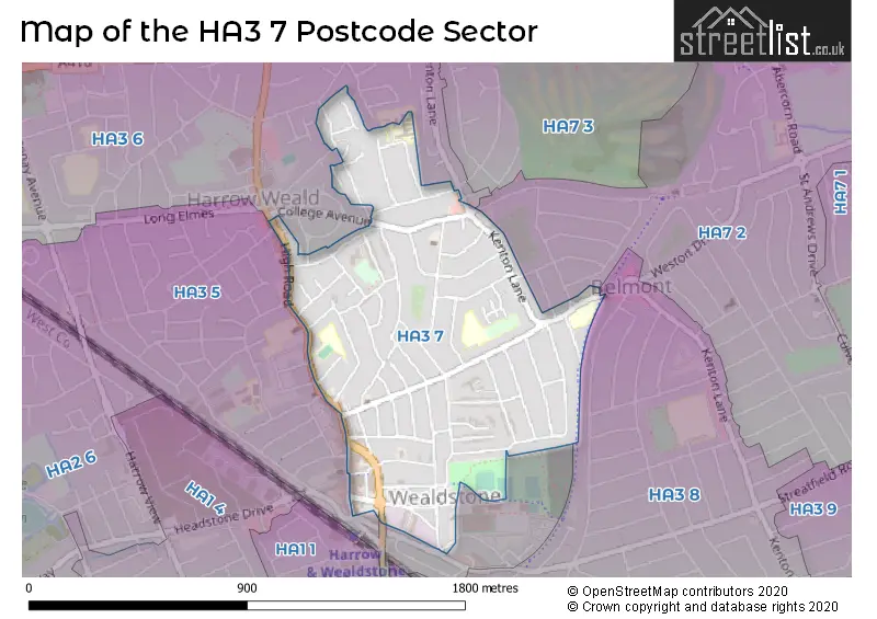
The HA3 7 Postcode shares a border with HA3 5 (HARROW , WEALDSTONE , HARROW WEALD ), HA3 6 (HARROW , HARROW WEALD ), HA3 8 (HARROW , KENTON ) and HA7 2 (STANMORE ).
Map of the HA3 7 Postcode Sector
Explore the HA3 7 postcode sector by using our interactive map.
The sector is within the post town of HARROW.
HA3 7 is a postcode sector within the HA3 postcode district which is within the HA Harrow postcode area.
The Royal Mail delivery office for the HA3 7 postal sector is the Harrow Central Delivery Office and Harrow Kenton & Weald Delivery Office.
The area of the HA3 7 postcode sector is 0.51 square miles which is 1.33 square kilometres or 327.72 square acres.
Your support helps keep this site running!
If you enjoy using this website, consider buying me a coffee to help cover hosting costs.


| H | A | 3 | - | 7 | X | X |
| H | A | 3 | Space | 7 | Letter | Letter |
Official List of Streets
HARROW (59 Streets)
Wealdstone (8 Streets)
(2 Streets)
Unofficial Streets or Alternative Spellings
HARROW
BRUCE ROAD CHRISTCHURCH AVENUE COLLEGE AVENUE GORDON ROAD PARK RISE WEALD LANE WHITEFRIARS DRIVESTANMORE
BEVERLEY GARDENS CURZON AVENUE MOUNTBEL ROAD MOUNTSIDE BELMONT TRAIL FRIARS WALK GREEN WAY GARDENS JOHN LAMB COURT THE GREEN WAYWealdstone
ARTISAN PLACEHarrow Weald
COLLEGE ROAD HIGH ROADWeather Forecast for HA3 7
Weather Forecast for Harrow
| Time Period | Icon | Description | Temperature | Rain Probability | Wind |
|---|---|---|---|---|---|
| 03:00 to 06:00 | Partly cloudy (night) | 3.0°C (feels like 0.0°C) | 1.00% | SE 7 mph | |
| 06:00 to 09:00 | Clear night | 2.0°C (feels like -1.0°C) | 0.00% | SE 4 mph | |
| 09:00 to 12:00 | Sunny day | 2.0°C (feels like 0.0°C) | 0.00% | SE 4 mph | |
| 12:00 to 15:00 | Sunny day | 5.0°C (feels like 3.0°C) | 0.00% | S 7 mph | |
| 15:00 to 18:00 | Sunny day | 7.0°C (feels like 5.0°C) | 0.00% | S 7 mph | |
| 18:00 to 21:00 | Clear night | 4.0°C (feels like 3.0°C) | 1.00% | S 4 mph | |
| 21:00 to 00:00 | Clear night | 3.0°C (feels like 1.0°C) | 1.00% | S 4 mph |
| Time Period | Icon | Description | Temperature | Rain Probability | Wind |
|---|---|---|---|---|---|
| 00:00 to 03:00 | Clear night | 1.0°C (feels like -1.0°C) | 2.00% | SSW 4 mph | |
| 03:00 to 06:00 | Cloudy | 1.0°C (feels like -1.0°C) | 7.00% | SSW 4 mph | |
| 06:00 to 09:00 | Overcast | 1.0°C (feels like -1.0°C) | 10.00% | SSW 4 mph | |
| 09:00 to 12:00 | Overcast | 2.0°C (feels like 0.0°C) | 9.00% | SSW 4 mph | |
| 12:00 to 15:00 | Cloudy | 6.0°C (feels like 4.0°C) | 5.00% | SSW 7 mph | |
| 15:00 to 18:00 | Sunny day | 7.0°C (feels like 5.0°C) | 2.00% | SSW 7 mph | |
| 18:00 to 21:00 | Partly cloudy (night) | 5.0°C (feels like 3.0°C) | 2.00% | S 7 mph | |
| 21:00 to 00:00 | Partly cloudy (night) | 4.0°C (feels like 2.0°C) | 3.00% | S 7 mph |
| Time Period | Icon | Description | Temperature | Rain Probability | Wind |
|---|---|---|---|---|---|
| 00:00 to 03:00 | Cloudy | 4.0°C (feels like 2.0°C) | 6.00% | SSW 7 mph | |
| 03:00 to 06:00 | Partly cloudy (night) | 4.0°C (feels like 2.0°C) | 3.00% | S 7 mph | |
| 06:00 to 09:00 | Partly cloudy (night) | 4.0°C (feels like 2.0°C) | 3.00% | SSW 9 mph | |
| 09:00 to 12:00 | Cloudy | 6.0°C (feels like 3.0°C) | 6.00% | SSW 9 mph | |
| 12:00 to 15:00 | Cloudy | 9.0°C (feels like 6.0°C) | 7.00% | SSW 11 mph | |
| 15:00 to 18:00 | Overcast | 9.0°C (feels like 7.0°C) | 15.00% | SSW 11 mph | |
| 18:00 to 21:00 | Light rain | 9.0°C (feels like 6.0°C) | 48.00% | SSW 9 mph | |
| 21:00 to 00:00 | Cloudy | 8.0°C (feels like 6.0°C) | 14.00% | SW 9 mph |
| Time Period | Icon | Description | Temperature | Rain Probability | Wind |
|---|---|---|---|---|---|
| 00:00 to 03:00 | Clear night | 6.0°C (feels like 4.0°C) | 5.00% | WSW 7 mph | |
| 03:00 to 06:00 | Clear night | 5.0°C (feels like 3.0°C) | 4.00% | W 7 mph | |
| 06:00 to 09:00 | Clear night | 3.0°C (feels like 1.0°C) | 2.00% | WNW 4 mph | |
| 09:00 to 12:00 | Cloudy | 4.0°C (feels like 2.0°C) | 4.00% | NW 4 mph | |
| 12:00 to 15:00 | Cloudy | 7.0°C (feels like 6.0°C) | 4.00% | NW 4 mph | |
| 15:00 to 18:00 | Cloudy | 8.0°C (feels like 7.0°C) | 4.00% | N 4 mph | |
| 18:00 to 21:00 | Cloudy | 5.0°C (feels like 4.0°C) | 5.00% | N 4 mph | |
| 21:00 to 00:00 | Cloudy | 4.0°C (feels like 2.0°C) | 4.00% | N 4 mph |
Schools and Places of Education Within the HA3 7 Postcode Sector
Belmont School
Community school
Hibbert Road, Harrow, Middlesex, HA3 7JT
Head: Mrs Poonam Aggarwall
Ofsted Rating: Outstanding
Inspection: 2012-05-24 (4637 days ago)
Website: Visit Belmont School Website
Phone: 02084270903
Number of Pupils: 652
Weald Rise Primary School
Community school
Robin Hood Drive, Harrow, , HA3 7DH
Head: Mrs Folake Agbaniyaka
Ofsted Rating: Good
Inspection: 2023-05-24 (620 days ago)
Website: Visit Weald Rise Primary School Website
Phone: 02089544531
Number of Pupils: 413
House Prices in the HA3 7 Postcode Sector
| Type of Property | 2018 Average | 2018 Sales | 2017 Average | 2017 Sales | 2016 Average | 2016 Sales | 2015 Average | 2015 Sales |
|---|---|---|---|---|---|---|---|---|
| Detached | £1,057,500 | 3 | £584,000 | 5 | £576,813 | 8 | £425,000 | 1 |
| Semi-Detached | £509,275 | 20 | £516,444 | 18 | £509,517 | 24 | £485,630 | 38 |
| Terraced | £439,607 | 36 | £431,717 | 30 | £431,730 | 50 | £395,715 | 52 |
| Flats | £258,822 | 37 | £283,651 | 38 | £299,705 | 40 | £253,234 | 61 |
Important Postcodes HA3 7 in the Postcode Sector
HA3 7AE is the postcode for London Borough of Harrow, Wealdstone Library, 38-40 High Street, and Wealdstone Library, 38-40 High Street
HA3 7AY is the postcode for Sacred Heart RC School, 186 High Street
HA3 7DH is the postcode for Weald First & Middle School, Robin Hood Drive
HA3 7EZ is the postcode for Harkett Court, 13 Harkett Close
HA3 7JJ is the postcode for John Lamb Court, The Bye Way
HA3 7JT is the postcode for Belmont First & Middle School, Hibbert Road
HA3 7LH is the postcode for 654, Kenton Lane, and VERNON LODGE, 654, Kenton Lane
HA3 7LP is the postcode for St. Josephs School, Dobbin Close
HA3 7LR is the postcode for Goddard Court, 10 Dobbin Close
HA3 7LT is the postcode for BELMONT HEALTH CENTRE, 516 KENTON LANE, HARROW, and Belmont Health Centre, 516 Kenton Lane
HA3 7SN is the postcode for GANGE CHILDRENS CENTRE, 68, Canning Road
| The HA3 7 Sector is within these Local Authorities |
|
|---|---|
| The HA3 7 Sector is within these Counties |
|
| The HA3 7 Sector is within these Water Company Areas |
|