A wide range of spatial data has been analysed to present this overview of the HA1 4 Postcode sector. If you would like anything added, please contact us.
The HA1 4 postcode sector is within the county of Greater London.
Did you know? According to the 2021 Census, the HA1 4 postcode sector is home to a bustling 15,414 residents!
Given that each sector allows for 400 unique postcode combinations. Letters C, I, K, M, O and V are not allowed in the last two letters of a postcode. With 259 postcodes already in use, this leaves 141 units available.
The largest settlement in the HA1 4 postal code is HARROW followed by WEST HARROW , and WEALDSTONE .
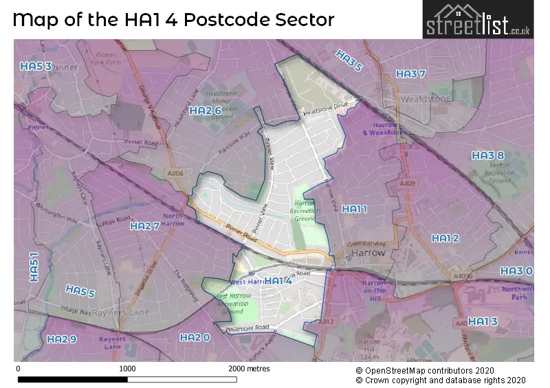
The HA1 4 Postcode shares a border with HA1 1 (HARROW ), HA2 6 (HARROW , NORTH HARROW , HARROW WEALD ), HA3 5 (HARROW , WEALDSTONE , HARROW WEALD ), HA1 3 (HARROW ), HA2 0 (HARROW , SOUTH HARROW , RAYNERS LANE ) and HA2 7 (HARROW , NORTH HARROW , RAYNERS LANE ).
Map of the HA1 4 Postcode Sector
Explore the HA1 4 postcode sector by using our interactive map.
The sector is within the post town of HARROW.
HA1 4 is a postcode sector within the HA1 postcode district which is within the HA Harrow postcode area.
The Royal Mail delivery office for the HA1 4 postal sector is the Harrow Central Delivery Office.
The area of the HA1 4 postcode sector is 0.76 square miles which is 1.98 square kilometres or 489.30 square acres.
Waterways within the HA1 4 postcode sector include the Yeading Brook.
Your support helps keep this site running!
If you enjoy using this website, consider buying me a coffee to help cover hosting costs.


| H | A | 1 | - | 4 | X | X |
| H | A | 1 | Space | 4 | Letter | Letter |
Official List of Streets
HARROW (76 Streets)
Unofficial Streets or Alternative Spellings
HARROW
BADMINTON CLOSE BLENHEIM ROAD COLLEGE ROAD FARMBOROUGH CLOSE HEADSTONE GARDENS HINDES ROAD JUNCTION ROAD KINGSFIELD AVENUE MARLBOROUGH HILL PARKSIDE WAY POOL ROAD PORLOCK AVENUE RADNOR ROAD SALISBURY ROAD VICTOR ROAD WELBECK ROAD WOODBERRY AVENUENorth Harrow
HARROW VIEW STATION ROADSouth Harrow
SHAFTESBURY AVENUE THE SPINGWAYHARROW,
PINNER ROADWeather Forecast for HA1 4
Weather Forecast for Harrow
| Time Period | Icon | Description | Temperature | Rain Probability | Wind |
|---|---|---|---|---|---|
| 09:00 to 12:00 | Partly cloudy (day) | 2.0°C (feels like 0.0°C) | 1.00% | SE 4 mph | |
| 12:00 to 15:00 | Sunny day | 5.0°C (feels like 3.0°C) | 1.00% | S 7 mph | |
| 15:00 to 18:00 | Sunny day | 7.0°C (feels like 5.0°C) | 0.00% | S 7 mph | |
| 18:00 to 21:00 | Clear night | 4.0°C (feels like 3.0°C) | 0.00% | SSW 4 mph | |
| 21:00 to 00:00 | Partly cloudy (night) | 3.0°C (feels like 1.0°C) | 0.00% | S 4 mph |
| Time Period | Icon | Description | Temperature | Rain Probability | Wind |
|---|---|---|---|---|---|
| 00:00 to 03:00 | Partly cloudy (night) | 2.0°C (feels like 0.0°C) | 1.00% | SSW 4 mph | |
| 03:00 to 06:00 | Cloudy | 1.0°C (feels like 0.0°C) | 7.00% | SSW 4 mph | |
| 06:00 to 09:00 | Overcast | 2.0°C (feels like 1.0°C) | 9.00% | S 4 mph | |
| 09:00 to 12:00 | Overcast | 4.0°C (feels like 2.0°C) | 10.00% | S 4 mph | |
| 12:00 to 15:00 | Overcast | 7.0°C (feels like 5.0°C) | 9.00% | SSW 7 mph | |
| 15:00 to 18:00 | Overcast | 8.0°C (feels like 6.0°C) | 8.00% | SSW 7 mph | |
| 18:00 to 21:00 | Overcast | 7.0°C (feels like 5.0°C) | 8.00% | S 7 mph | |
| 21:00 to 00:00 | Cloudy | 6.0°C (feels like 3.0°C) | 6.00% | SSW 9 mph |
| Time Period | Icon | Description | Temperature | Rain Probability | Wind |
|---|---|---|---|---|---|
| 00:00 to 03:00 | Cloudy | 6.0°C (feels like 3.0°C) | 6.00% | SSW 9 mph | |
| 03:00 to 06:00 | Cloudy | 6.0°C (feels like 3.0°C) | 5.00% | SSW 9 mph | |
| 06:00 to 09:00 | Overcast | 7.0°C (feels like 4.0°C) | 8.00% | SSW 9 mph | |
| 09:00 to 12:00 | Overcast | 7.0°C (feels like 4.0°C) | 8.00% | SSW 11 mph | |
| 12:00 to 15:00 | Cloudy | 9.0°C (feels like 6.0°C) | 5.00% | SSW 13 mph | |
| 15:00 to 18:00 | Overcast | 10.0°C (feels like 7.0°C) | 13.00% | SSW 11 mph | |
| 18:00 to 21:00 | Light rain | 9.0°C (feels like 6.0°C) | 61.00% | SSW 11 mph | |
| 21:00 to 00:00 | Light rain shower (night) | 9.0°C (feels like 6.0°C) | 38.00% | WSW 9 mph |
| Time Period | Icon | Description | Temperature | Rain Probability | Wind |
|---|---|---|---|---|---|
| 00:00 to 03:00 | Clear night | 7.0°C (feels like 4.0°C) | 3.00% | WSW 9 mph | |
| 03:00 to 06:00 | Clear night | 5.0°C (feels like 2.0°C) | 1.00% | W 7 mph | |
| 06:00 to 09:00 | Clear night | 4.0°C (feels like 1.0°C) | 0.00% | W 7 mph | |
| 09:00 to 12:00 | Partly cloudy (day) | 4.0°C (feels like 2.0°C) | 1.00% | W 4 mph | |
| 12:00 to 15:00 | Cloudy | 7.0°C (feels like 5.0°C) | 4.00% | WNW 4 mph | |
| 15:00 to 18:00 | Cloudy | 8.0°C (feels like 7.0°C) | 4.00% | NW 4 mph | |
| 18:00 to 21:00 | Partly cloudy (night) | 5.0°C (feels like 4.0°C) | 1.00% | NW 4 mph | |
| 21:00 to 00:00 | Partly cloudy (night) | 4.0°C (feels like 2.0°C) | 1.00% | NNW 4 mph |
| Time Period | Icon | Description | Temperature | Rain Probability | Wind |
|---|---|---|---|---|---|
| 00:00 to 03:00 | Clear night | 3.0°C (feels like 1.0°C) | 1.00% | N 4 mph | |
| 03:00 to 06:00 | Clear night | 2.0°C (feels like 0.0°C) | 1.00% | NNE 4 mph | |
| 06:00 to 09:00 | Clear night | 1.0°C (feels like -1.0°C) | 1.00% | NNE 4 mph | |
| 09:00 to 12:00 | Sunny day | 2.0°C (feels like 0.0°C) | 1.00% | NE 4 mph | |
| 12:00 to 15:00 | Sunny day | 6.0°C (feels like 4.0°C) | 1.00% | ENE 7 mph | |
| 15:00 to 18:00 | Sunny day | 7.0°C (feels like 5.0°C) | 1.00% | ENE 7 mph | |
| 18:00 to 21:00 | Clear night | 5.0°C (feels like 3.0°C) | 1.00% | NE 7 mph | |
| 21:00 to 00:00 | Clear night | 4.0°C (feels like 1.0°C) | 1.00% | NE 7 mph |
Schools and Places of Education Within the HA1 4 Postcode Sector
Vaughan Primary School
Community school
The Gardens, Vaughan Road, Harrow, Middlesex, HA1 4EL
Head: Mrs Karen Jones
Ofsted Rating: Outstanding
Inspection: 2019-01-16 (2209 days ago)
Website: Visit Vaughan Primary School Website
Phone: 02084277222
Number of Pupils: 668
House Prices in the HA1 4 Postcode Sector
| Type of Property | 2018 Average | 2018 Sales | 2017 Average | 2017 Sales | 2016 Average | 2016 Sales | 2015 Average | 2015 Sales |
|---|---|---|---|---|---|---|---|---|
| Detached | £731,500 | 2 | £668,700 | 5 | £690,000 | 3 | £600,000 | 2 |
| Semi-Detached | £618,969 | 40 | £543,875 | 25 | £532,980 | 31 | £530,839 | 44 |
| Terraced | £484,584 | 47 | £516,348 | 48 | £496,912 | 42 | £481,654 | 54 |
| Flats | £316,041 | 52 | £312,694 | 59 | £325,032 | 68 | £285,373 | 87 |
Important Postcodes HA1 4 in the Postcode Sector
HA1 4BX is the postcode for St. Peters Medical Centre, Sumner Road
HA1 4DH is the postcode for 19, Marshall Close
HA1 4EA is the postcode for Neighbourhood Resource Centre, Wilson Gardens
HA1 4EL is the postcode for Vaughan Primary School, Vaughan Road
HA1 4ES is the postcode for Khalsa College London, 35 Pinner Road
HA1 4HN is the postcode for Social Services, 429-433 Pinner Road
HA1 4TR is the postcode for Unit 11, Waverley Industrial Estate
HA1 4TU is the postcode for Harrow Crown Courts, Hailsham Drive, and HARROW CROWN COURTS, HAILSHAM DRIVE, HARROW
HA1 4UQ is the postcode for Caryl Thomas Clinic, Headstone Centre, Headstone Drive
| The HA1 4 Sector is within these Local Authorities |
|
|---|---|
| The HA1 4 Sector is within these Counties |
|
| The HA1 4 Sector is within these Water Company Areas |
|