A wide range of spatial data has been analysed to present this overview of the GU10 5 Postcode sector. If you would like anything added, please contact us.
The GU10 5 postcode sector stands on the Hampshire and Surrey border.
Did you know? According to the 2021 Census, the GU10 5 postcode sector is home to a bustling 4,454 residents!
Given that each sector allows for 400 unique postcode combinations. Letters C, I, K, M, O and V are not allowed in the last two letters of a postcode. With 211 postcodes already in use, this leaves 189 units available.
The largest settlement in the GU10 5 postal code is Crondall followed by Bentley, and Ewshot.
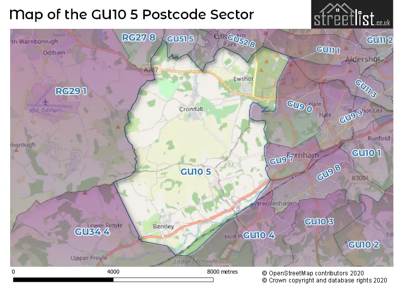
The GU10 5 Postcode shares a border with GU34 4 (Holybourne, Beech, Upper Froyle), GU51 5 (FLEET, Crookham Village, Church Crookham), GU52 8 (Church Crookham), RG27 8 (Hartley Wintney, Winchfield, Dogmersfield), RG29 1 (Odiham, North Warnborough, South Warnborough), GU9 0 (FARNHAM, Upper Hale), GU52 0 (Church Crookham), GU9 7 (FARNHAM), GU9 8 (FARNHAM), GU10 4 (Wrecclesham, Rowledge, Dockenfield) and GU11 1 (ALDERSHOT, Wellesley).
Map of the GU10 5 Postcode Sector
Explore the GU10 5 postcode sector by using our interactive map.
The sector is within the post town of FARNHAM.
GU10 5 is a postcode sector within the GU10 postcode district which is within the GU Guildford postcode area.
The Royal Mail delivery office for the GU10 5 postal sector is the Farnham Delivery Office.
The area of the GU10 5 postcode sector is 14.97 square miles which is 38.77 square kilometres or 9,580.04 square acres.
Waterways within the GU10 5 postcode sector include the Wey, Basingstoke Canal.
Your support helps keep this site running!
If you enjoy using this website, consider buying me a coffee to help cover hosting costs.

| G | U | 1 | 0 | - | 5 | X | X |
| G | U | 1 | 0 | Space | 5 | Letter | Letter |
Official List of Streets
FARNHAM (10 Streets)
Crondall (29 Streets)
Bentley (19 Streets)
Ewshot (26 Streets)
(35 Streets)
Dippenhall (2 Streets)
Runwick (1 Streets)
Unofficial Streets or Alternative Spellings
Church Crookham
ALLAMAND CLOSE BEACON HILL ROAD BOURLEY ROAD BYRNE AVENUE CHANNER GARDENS NAISHES LANE REDFIELDS LANE THAPA CLOSEFARNHAM
RIVER LANEWrecclesham
WESTFIELD LANE BABS FIELDS BASINGSTOKE CANAL TOWPATH BENTLEY BYPASS BOURLEY LANE BUTTERFLY TRAIL CLARE PARK HOSPITAL CLARE PARK ROAD COXBRIDGE BUSINESS PARK DIPPENHALL HOUSE DOWNS VIEW LOOP ENDEAVOUR PLACE EWSHOT HILL HISTORIC (ALMOST IMPASSIBLE) PATH HOLMES FIELD COURT HUSSEYS LANE NORTHBROOK ESTATE NUGENT CLOSE REDWOOD TRAIL RIVER ROAD ROKE LANE RUNWICK COTTAGES SAINT CROSS ROAD ST. SWITHUNS WAY THE COURT THE DROVE THE ENTERPRISE CENTRE THE FIELD WELLS CHASE WEY BANK WILLEY FARM WILLEY PLACEBentley
OLD STATION ROAD VICKERY LANEWeather Forecast for GU10 5
Weather Forecast for Jenkyn Place Gardens
| Time Period | Icon | Description | Temperature | Rain Probability | Wind |
|---|---|---|---|---|---|
| 03:00 to 06:00 | Overcast | 4.0°C (feels like 2.0°C) | 10.00% | ESE 4 mph | |
| 06:00 to 09:00 | Overcast | 4.0°C (feels like 2.0°C) | 10.00% | ESE 4 mph | |
| 09:00 to 12:00 | Overcast | 4.0°C (feels like 2.0°C) | 10.00% | SE 4 mph | |
| 12:00 to 15:00 | Overcast | 6.0°C (feels like 4.0°C) | 9.00% | SSE 9 mph | |
| 15:00 to 18:00 | Cloudy | 6.0°C (feels like 3.0°C) | 8.00% | SSE 9 mph | |
| 18:00 to 21:00 | Partly cloudy (night) | 4.0°C (feels like 1.0°C) | 3.00% | SSE 7 mph | |
| 21:00 to 00:00 | Partly cloudy (night) | 3.0°C (feels like 0.0°C) | 2.00% | SSE 7 mph |
| Time Period | Icon | Description | Temperature | Rain Probability | Wind |
|---|---|---|---|---|---|
| 00:00 to 03:00 | Clear night | 2.0°C (feels like -1.0°C) | 2.00% | SSE 7 mph | |
| 03:00 to 06:00 | Clear night | 2.0°C (feels like -1.0°C) | 2.00% | SSE 7 mph | |
| 06:00 to 09:00 | Clear night | 2.0°C (feels like -2.0°C) | 1.00% | SSE 7 mph | |
| 09:00 to 12:00 | Sunny day | 2.0°C (feels like 0.0°C) | 3.00% | SSE 7 mph | |
| 12:00 to 15:00 | Sunny day | 6.0°C (feels like 3.0°C) | 3.00% | S 9 mph | |
| 15:00 to 18:00 | Sunny day | 6.0°C (feels like 4.0°C) | 2.00% | S 7 mph | |
| 18:00 to 21:00 | Clear night | 2.0°C (feels like 0.0°C) | 3.00% | SSW 4 mph | |
| 21:00 to 00:00 | Clear night | 1.0°C (feels like -1.0°C) | 1.00% | S 4 mph |
| Time Period | Icon | Description | Temperature | Rain Probability | Wind |
|---|---|---|---|---|---|
| 00:00 to 03:00 | Clear night | 1.0°C (feels like -2.0°C) | 2.00% | SSW 4 mph | |
| 03:00 to 06:00 | Clear night | 1.0°C (feels like -2.0°C) | 3.00% | SSW 4 mph | |
| 06:00 to 09:00 | Partly cloudy (night) | 1.0°C (feels like -2.0°C) | 4.00% | SSW 4 mph | |
| 09:00 to 12:00 | Partly cloudy (day) | 3.0°C (feels like 0.0°C) | 5.00% | S 7 mph | |
| 12:00 to 15:00 | Cloudy | 7.0°C (feels like 4.0°C) | 5.00% | SSW 9 mph | |
| 15:00 to 18:00 | Cloudy | 8.0°C (feels like 5.0°C) | 5.00% | SSW 9 mph | |
| 18:00 to 21:00 | Cloudy | 5.0°C (feels like 2.0°C) | 5.00% | S 9 mph | |
| 21:00 to 00:00 | Cloudy | 5.0°C (feels like 2.0°C) | 7.00% | S 9 mph |
| Time Period | Icon | Description | Temperature | Rain Probability | Wind |
|---|---|---|---|---|---|
| 00:00 to 03:00 | Partly cloudy (night) | 5.0°C (feels like 2.0°C) | 4.00% | S 11 mph | |
| 03:00 to 06:00 | Cloudy | 5.0°C (feels like 2.0°C) | 9.00% | SSW 11 mph | |
| 06:00 to 09:00 | Cloudy | 6.0°C (feels like 2.0°C) | 11.00% | SSW 11 mph | |
| 09:00 to 12:00 | Cloudy | 7.0°C (feels like 3.0°C) | 14.00% | SSW 11 mph | |
| 12:00 to 15:00 | Cloudy | 9.0°C (feels like 6.0°C) | 17.00% | SSW 13 mph | |
| 15:00 to 18:00 | Overcast | 9.0°C (feels like 6.0°C) | 49.00% | SSW 11 mph | |
| 18:00 to 21:00 | Light rain | 8.0°C (feels like 5.0°C) | 48.00% | SW 9 mph | |
| 21:00 to 00:00 | Partly cloudy (night) | 7.0°C (feels like 4.0°C) | 15.00% | WSW 9 mph |
Schools and Places of Education Within the GU10 5 Postcode Sector
Bentley Church of England Primary School
Voluntary controlled school
School Lane, Farnham, Surrey, GU10 5JP
Head: Mrs Victoria Hallett
Ofsted Rating: Good
Inspection: 2021-09-15 (1235 days ago)
Website: Visit Bentley Church of England Primary School Website
Phone: 01420525010
Number of Pupils: 205
House Prices in the GU10 5 Postcode Sector
| Type of Property | 2018 Average | 2018 Sales | 2017 Average | 2017 Sales | 2016 Average | 2016 Sales | 2015 Average | 2015 Sales |
|---|---|---|---|---|---|---|---|---|
| Detached | £902,611 | 40 | £750,288 | 41 | £911,121 | 38 | £906,442 | 43 |
| Semi-Detached | £417,222 | 9 | £462,842 | 22 | £539,563 | 16 | £542,235 | 10 |
| Terraced | £393,889 | 9 | £428,223 | 11 | £359,075 | 12 | £396,550 | 10 |
| Flats | £222,500 | 1 | £284,150 | 6 | £293,725 | 4 | £425,000 | 1 |
Important Postcodes GU10 5 in the Postcode Sector
GU10 5JP is the postcode for Bentley C of E School, School Lane
GU10 5QG is the postcode for Crondall Cp School, Croft Lane
| The GU10 5 Sector is within these Local Authorities |
|
|---|---|
| The GU10 5 Sector is within these Counties |
|
| The GU10 5 Sector is within these Water Company Areas |
|